Facebook: http://www.facebook.com/Rvawx
Twitter: @RVA_WX
Follow us!
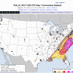
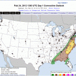
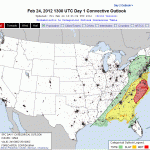
The severe weather outlook looks quite ominious for this afternoon:

Days With High Temps Above Avg: 17
Days With Low Temps Above Avg: 11
Highest Temp: 72.1 on 2/23
Lowest Temp: 14.7 on 2/13
Mean Temp thru the 23rd: 42.8
Snow: 3.9″ on 2/18 (RIC only had a trace before this)
After last weekend’s weak Winter storm that dumped 3-6″ across RVA, will we see any more? Chances are slim to none. With temps reaching 70+ today, the snow is a distant memory. We could also see some thunderstorms tomorrow evening. NAM CAPE values of 500+ could, along with strong upper shear, create some decent severe weather from Richmond and south.
A cold front will move in Saturday with highs in the 50’s. Then its back to the 60’s again.
The current GFS shows a nice rain event on March 1st, and a bigger one on the 4th and 5th. So…Winter 11-12′, goodbye. Stay tuned for an in depth look at this Winter and its impacts on the RVA. We’ll soon be transitioning to severe weather discussion.


The first real substantial storm of the winter season struck on Sunday, prior to President’s Day. The precipitation started around 9:00 AM and remained light and intermittent until 5:00 PM.Moderate to heavy snow was reported at the airport from 6 PM to 12 PM that evening. A total of 3.9″ was reported at the airport. To date, this was the largest snow event of the season and largest event since the Christmas Day storm of 2010.
The forecast for this storm remained tricky up to the day of the event. Models shifted course the night before the event, drastically reduced snowfall forecasts from 3-6″ to 2-4″ for Richmond and the surrounding counties. A winter storm watch had been issued on Saturday for the a large portion of central Virginia. My Sunday morning, the watch was converted to an advisory with the likelihood that snow totals would not exceed 2″ of snow. Storm totals for Metro Richmond ranged from 1.5″ to 5″ of snow. A snow burst moved through Metro Richmond between 5:30 and 7:30 PM, which gave some areas up to 2″ of snow in two hours!


My Report (Church Hill):
* Place – Time: Church Hill, 11:35 PM (2/19/2012) *After the Event Update*
* Temperature: 33-42, During Storm Event
* Dewpoint: 25-33, During Storm Event
* Relative Humidity: 95%
* Pressure: N/A
* Trends: N/A
*Winter Weather Watch/Warning/Advisory: Watch & Advisory
* Road Conditions: All roads had snow cover during the event. The morning after the event on President’s Day, secondary roads slushy. Major roads passable.
* Precipitation Description: Light, moderate and sometimes heavy snow fell throughout the event. Rain, sleet and gropple fell during the event, especially towards the beginning.
* Total Precip: 4.0″ of snow. Liquid Equivalent of 0.83″ fell during the event at the airport.
* Comments: Precipitation started at 10:00 AM as a light mix of flurries and drizzle. The precipitation fell as light to occasionally moderate snow throughout the morning and early afternoon hours. Little to no accumulation through 5 PM. The precipitation quickly changed to moderate and heavy snow by 6 PM where local roads began to get covered. About 1 and ½ hours of heavy snow was reported in and around RIC airport around 6-7 PM. The snow began to taper off by 12 AM on Monday morning. Snow was very wet, with ratios close to 6:1. Precipitation was spurred by an upper level low that tracked up from the gulf coast to off the Hatteras coast. No winter storm warning was issued, only a winter weather advisory was issued for Sunday afternoon and Monday morning. On Saturday, the day before the event, highs were in the mid-60’s in Central Virginia. The airport reported 3.9” of snow.
Photo Gallery Link: http://www.612.richmondcitywatch.com/modules/gallery2/main.php?g2_itemId=2788
Radar Loop from KAKQ for the entire event here:
Could Metro Richmond be in store for a President’s Day storm in 2012? The likelihood of a possible winter weather event for Central Virginia is gaining traction today. A lot of caution needs to be placed on the table as the models for this event have been all over the board this week. On Sunday and Monday, the lower Middle Atlantic seemed to be in the cross-hairs of a potential major storm for this weekend. By mid-week, the threat shifted north and east of Central Virginia to include DC through NYC. The models (for the time being) have reined in the idea of a coastal storm exiting Carolina coast and cruising up the eastern seaboard. Now, the storm stays suppressed and hammers the majority of the wintery precipitation through WVA, VA and parts of MD and DE. Still a lot of time for the models and overall model consensus on this storm to shift. In the meantime, Richmond has a slight chance of having our first major winter storm of the season.
Below are some current predictions based on the models this afternoon:


Updates for 2/17/2012:
The chances for accumulating snow Sunday afternoon, evening and early Monday are increasing. The NAM this morning buried Richmond with 8-11″ of snow. I’m still unsure if this will pan out, but it looks like we have something fun to watch! Also, the 12Z GFS today still shows 3-4″ of snow for Richmond. The trend looks to be our friend if you are a snow lover!


* Place – Time: Church Hill, 3:35 PM (1/28/2011) *After the Event Update*
* Temperature: 35-44, During Storm Event
* Dewpoint: 32-34, During Storm Event
* Relative Humidity: N/A
* Pressure: N/A
* Trends: N/A
* Road Conditions: Primary roads passable. Secondary roads passable as well.
* Precipitation Description: Light, moderate and sometimes heavy snow fell throughout the event.
* Total Precip: 0.2″ of snow on mulch, grass and elevated surfaces. Liquid Equivalent of 0.06″ fell during the event.
* Comments: Precipitation started at 3:35 PM as a very brief mix of gropple and snow. The precipitation quickly changed to moderate and heavy snow with winds sustained between 10-20 MPH. Precipitation was spurred by an arctic frontal boundary that created a squall line through central Virginia. Thunder preceding the event could be heard to the south and was reported to the NWS during the event as it rolled through Metro Richmond. Snow lasted for about 30 minutes.
The next weather headline coming our way this weekend involves a frontal boundary that will usher in a brief bout of arctic air for Sunday into Monday for Metro Richmond. As the frontal passage comes through, there is a small chance of the rain changing to snow in Central Virginia. It looks unlikely that any accumulating snow will fall from this event. The NWS has us recieving some rain showers and nothing else from the frontal passage. Nonetheless, it is a possible snow event to watch evolve over the next two days. In any case, a windy and winter like day is in store for Sunday (2/12/12).


