Church Hill Storm Observation Summary:
* Place – Time: Church Hill, (1/15/2015)
* Temperature: 30-32, During Event
* Winter Weather Watch/Warning/Advisory: None
* Closings: All local school districts had a delayed opening or were closed, Chesterfield County Government had a delayed opening for 10:00 AM.
* Predicted Totals: Dusting of snow.
* Road Conditions: All roads had varying amounts of snow, mostly in areas where previous ice from the 14th had not melted. Streets cleared by 10 AM.
* Precipitation Description: Snow.
* Total Precipitation: Trace of snow accumulation (light dusting). Snow on most surfaces. 0.00″ of liquid equivalent was reported at the Richmond airport.
* Comments: Low-level moisture from a surprise system overnight (12 AM – 3 AM) left a layer of light snow on most surfaces. The chance of snow was not discussed in the forecast.
Tag Archives: flurries
January 16, 2014: Rain Showers to Snow Showers
A possible light winter weather event may occur tonight from a weak system moving across the area. Little to no accumulation of snow is excepted. However, with no accumulating snow yet this season, there is a slim chance this could serve to be the first event to give us more than a trace of snowfall.
NWS Discussion:
.SHORT TERM /6 PM THIS EVENING THROUGH FRIDAY/…
ACTIVE NRN STREAM RMNS DOMINANT THROUGH FRI. COLDER AIR GRADUALLY
SPREAD OVR THE RGNTNGT…AS LO PRES IS SLO TO DVLP OFF THE CST.
WKNG S/W ALOFT CROSSES THE RGNTNGT/THU MRNG KEEPING MOISTURE AND
RATHER WKUVM (BTWN H85-H7). MAY BE ENOUGH TO SQUEEZE OUT LGTPCPN
TNGT…ESP INLAND. WINTER PARAMETERS CONT TO SUGGEST LO PROB FOR
TRANSITION TO MIXED PTYPE OR (JUST) SN STARTING OUT OVR THE PDMNT
AND SLOLY SPREADING E (BY ERY THU MRNG). QPF IS XPCD TO BE AOB
0.05″…PTNTLLY ENUF FOR A SMALL/SLUSHY ACCUM FOR PARTS OF THE
AREA W OF I 95. LO TEMPS FM THE U20S FAR W TO THE M30S TO THE E.HOLDING ONTO CLDS AND CHCPOPSNR THE CST THU MRNG ASSOCIATED W/
DVLPG LO PRES OFFSHR. A CLRG TREND FM W TO E XPCD MIDDAY THROUGH
AFTN AS THAT LO BEGINS TO PULL AWAY FM THE CST. YET ANOTHER CDFNT
APPROACHES FM THE W ON FRI…REACHING THE CST VERY LT IN THE DAY.
MOISTUREFM THAT SYS LIMITED…SO POPS TO BE QUITE LO (AOB 14% FOR
NOW). OTRW…CLR-PC THU NGT THROUGH FRI.HIGHS TEMPS THU WILL ONLY RECOVER INTO THE L/M 40S. FEW GUSTS UP
TO 20-30 MPH POSSIBLE ALONG THE COAST THU MRNG. MILDER FRI W/ HI
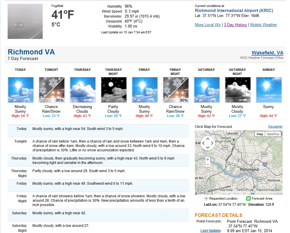
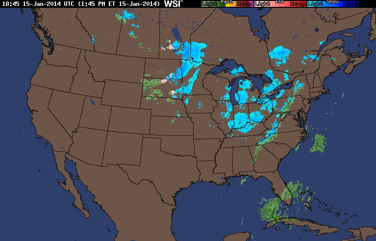
TEMPS FM THE M40S TO L50S.Update from 4 PM on 1/15/2014:
WITH THAT SAID…EXPECT PRECIP TO DEVELOP OVER THE PIEDMONT LATE
TODAY INTO EARLY THIS EVENING AND PERSIST THROUGH LATE
TONIGHT…REMAINING ALONG AND WEST OF INTERSTATE 95. WHILE PRECIP
WILL BE LIGHT…HAVE OPTED TO INCREASE POPS TO LIKELY. THICKNESSES
BEGIN TO RAPIDLY FALL THIS EVENING AS COLDER AIR SURGES INTO THE
REGION. HOWEVER…TEMPS ONLY EXPECTED TO FALL INTO THE LOW
30S…SO TRANSITION OVER TO SNOW WILL BE SLOW…LIKELY OCCURRING
AFTER MIDNIGHT. EXPECT SNOWFALL AS FAR EAST AS INTERSTATE 95 BY
THURS MORNING. QPF WILL LIKELY BE LESS THAN ONE TENTH OF AN INCH.
ANTICIPATE ONLY MINOR/SLUSHY SNOW ACCUMULATIONS (<.05 INCHES) ON
GRASSY OR COLD SURFACES FROM FARMVILLE NWD TO LOUISA…WELL BELOW
ADVISORY CRITERIA.— End Changed Discussion —
January 24, 2013: Observations
This ended up being a fairly minor event with approximately 0.2″ of snow accumulation.
My Report (Church Hill):
* Place – Time: Church Hill, 11:00 AM (2/3/2013) *After the Event Update*
* Temperature: N/A
* Dewpoint: N/A
* Relative Humidity: N/A
* Pressure: N/A
* Trends: N/A
*Winter Weather Watch/Warning/Advisory: None
* Road Conditions: All roads had snow cover during the event. The morning after the event, secondary roads remained covered. Most major roads cleared.
* Precipitation Description: Light snow fell throughout the event.
* Total Precip: 0.2″ of snow. Liquid Equivalent of a trace fell during the event at the airport.
* Comments: Snow started shortly after midnight on the 24th. The precipitation fell as light to occasionally moderate snow throughout the early morning hours. The airport reported 0.2” of snow.