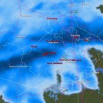
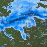
 Our last chance for snow from this dynamic storm system is getting closer to reaching metro Richmond this afternoon and evening. Will we see heavy wet snow as forecasted by NWS? The radar looks promising as we recieve some thunderstorms first, followed by snow this evening!
Monthly Archives: January 2011
Snowstorm Profile: January 6-8th Storm of 1996 (Blizzard of 96′)
Weather Event: Blizzard of 1996
Location of Observation: Midlothian, Virginia
Precipitation Type: Heavy Snow
Dates of Observation: January 6-7, 1996
Official Observation/Storm Total from RIC: 11.5″
Synoptic Overview of Storm System: The storm formed in the Gulf of Mexico the morning of the 6th, moved south of Alabama the evening of the 6th, reached Savannah, Georgia the morning of the 7th, Cape Hattaras the evening of the 7th, just east of the Delaware Bay the morning of the 8th, and the southern New England coastal waters the evening of the 8th. This was a classic storm track for heavy snow.
Personal Observations & Memories: Besides the January 2000 snowstorm, some of my best snow memories were created by this storm. I still remember when the first flakes began to fall with this storm system. The air was cold from the onset so all of the snow stuck right away to the grass and pavement. Snowfall intensity remained fairly light through the early afternoon until about nightfall. By the evening, the brunt of the storm was moving into the area. Incredibly heavy snow began falling from sunset until almost 4 AM in the morning. I ventured out with friends in the heavy snowfall, amazed at how quickly the snow piled up. It come as a disappointment later on in the evening when the snow fall began to taper off and change to sleet. If my memory serves me correctly, the sleet lasted for a few hours, compacting the 10-12 inches that had fallen already. Wrap around snow came to the rescue later on the 7th, adding another shot of 6-10 inches on what had already fallen. Unofficial measurements taken by me at the time easily pegged this storm between 18-19″ of snow in Central Chesterfield. it would be a couple days later where a second system left Central Virginia with 3-6″ of more snow on top of what had already fallen.
At the time of this storm, I was 13 years old and in 8th grade. This storm hit metropolitan Richmond not long after school resumed from Winter Break. Schools ended up closing for nearly 2 weeks (8.5 days total, eight full days off with 2 school days with delayed openings) and most of the midterm exams canceled due to the snowfall. As a student, I was elated to have all of my exams cancelled!
Images:


Links:
January 25-26, 2011: Forecast *CLOSED*
*Update: 1/23/2011
It looks like a potentially big rain storm, with a brush of wintry precipitation might be the best bet for Metro Richmond at this point. While the weather models still vary the storm in it’s track and location, the absence of cold air will make it difficult to see much snow along I-95. Monday and Tuesday will prove interesting to see how the forecast pans out for this system. The current NWS Forecast follows:

NWS Forecast as of 1/21/2010:
Monday Night: A chance of snow. Cloudy, with a low around 27. Chance of precipitation is 30%.
Tuesday: A chance of rain, snow, and sleet. Cloudy, with a high near 37. Chance of precipitation is 50%.
Tuesday Night: Rain likely. Mostly cloudy, with a low around 29. Chance of precipitation is 60%.
Wednesday: A chance of rain and snow showers. Mostly sunny, with a high near 43. Chance of precipitation is 40%.
The big question at this point is what type of precipitation will fall in Central Virginia. This will be determined by the storm track, the location of the high pressure in the northeast and how strong this storm will develop. The models still seem to be flip-flopping around on all three of these variables. As usual, it’ll come down to the wire to determine what type of event this will be for Central Virginia.
January 20-21, 2011: Observations *CLOSED*
NWS Forecast, 1/20/2011:
This Afternoon: Increasing clouds, with a high near 45. South wind around 6 mph.
Tonight: A chance of rain before midnight, then rain and snow likely. Cloudy, with a low around 34. Southeast wind 5 to 8 mph becoming west. Chance of precipitation is 60%. Little or no snow accumulation expected.
Current Radar:

TWC Forecast:

January 20-21, 2011: Forecast *CLOSED*
The next possible winter weather event for Central Virginia appears to be coming from a low-pressure system that will develop along a cold front Thursday night into Friday morning. As of this morning (1/18/2011), NWS and NBC12 are forecasting primarily rain for this event. Some of the weather models as of noon today are still bullish on pushing snow into the area. Richmond remains close to the 32-degree line. While QPF from this system remains light (around 0.10″), the possibility exists for Central Virginia to see some light snow on the tail end of this event. As this low hits the coast, there is the possibility that it strengthens and develops into a Miller B storm for the Northeast and New England.
12Z NAM:

12Z GFS

2010 Statistics: Highest 24-Hour Rainfall
Church Hill: 3.36″
One impressive statistic from the 2010 weather data that was recorded at my house was the highest amount of liquid rainfall accumulating in a 24-hour period. Signaling the end of summer and an extreme drought, my station recorded 3.36″ of rain in a single day. The radar loop from the day is impressive as well. The rain was spawned from the remnants of Nicole and a coastal low.

More information on the remnants of Nicole (Wikipedia)
January 18-19, 2011: Forecast *CLOSED*
Update: 1/17/2011
**While cold air has filtered into place over Central Virginia, it appears that this will primarily be a rain event for tonight into Wednesday morning. There may be a little sleet at the onset of the precipitation, but no accumulation is expected. All eyes are now on the next potential winter storm which may arrive in Virginia by 1/21. **
The possibility of winter weather looks unlikely over the next week to ten days. The next substantial storm on the horizon is slated to cross the area on Monday and Tuesday of next week (January 18-19). Most models currently show a rain solution for this storm as it tracks well west of Central Virginia. One model, the GGEM, shows the possibility for some initial snow/ice at the onset, followed by rain for the duration of the event.
GGEM, 1/13/2011

GFS, 1/13/2011

Video from Event:
January 11, 2011: Wx Observations *CLOSED*
The forecast for tomorrow’s winter storm that is now hammering the southeast has changed substantially in the past few days. Hints of this winter storm were first seen in late December (see Wxrisk.com). About 3-5 days ago, there was the possibility that this storm could drop anywhere from 3-6″ of snow in Central Virginia. As the event comes closer to realization, the models have shifted the development of this low off the Virginia and Delmarva coast. Consequently, Central Virginia is forecast to be sparred the majority of precipitation from this event. The other major change in the forecast is the precipitation type. The development and proximity of the coastal low is projected to turn the snow into sleet and freezing rain for a large portion of Central Virginia tomorrow. Plain old rain may even mix in before the wrap-around moisture turns the precipitation back to snow. This will substantially cut down on any snowfall accumulation tomorrow. The NWS current forecast for “23223″ is for 0.5 – 1″ total of snow and ice. Winter Weather Advisories have also been posted this morning for the majority of Central Virginia in anticipation of the upcoming winter storm. Storm reports will be posted tomorrow morning as the event unfolds.
Current Forecast Maps:


Videos of Event:
Photos of the Event (Church Hill):
Photo-Book of the Jan 7th Snow


January 7-8, 2011: Wx Observations *CLOSED*
An impressive band of moisture has set up over Metro Richmond these evening. An upper level low coming out the great lakes has made spun some moisture over the mountains and we have has some impressive snowfall this evening. Already a dusting of snow is on most surfaces and the snow appears to be sticking around for the next few hours. Maybe 1/2″ to 1″ might be possible?
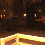
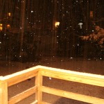
Two videos from Church Hill last night: