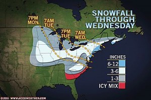
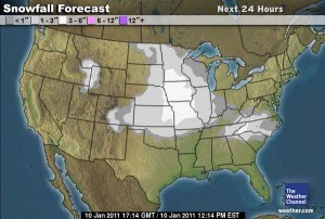
The forecast for tomorrow’s winter storm that is now hammering the southeast has changed substantially in the past few days. Hints of this winter storm were first seen in late December (see Wxrisk.com). About 3-5 days ago, there was the possibility that this storm could drop anywhere from 3-6″ of snow in Central Virginia. As the event comes closer to realization, the models have shifted the development of this low off the Virginia and Delmarva coast. Consequently, Central Virginia is forecast to be sparred the majority of precipitation from this event. The other major change in the forecast is the precipitation type. The development and proximity of the coastal low is projected to turn the snow into sleet and freezing rain for a large portion of Central Virginia tomorrow. Plain old rain may even mix in before the wrap-around moisture turns the precipitation back to snow. This will substantially cut down on any snowfall accumulation tomorrow. The NWS current forecast for “23223″ is for 0.5 – 1″ total of snow and ice. Winter Weather Advisories have also been posted this morning for the majority of Central Virginia in anticipation of the upcoming winter storm. Storm reports will be posted tomorrow morning as the event unfolds.
Current Forecast Maps:
Videos of Event:
Photos of the Event (Church Hill):


* Place – Time: Church Hill, 10:00 AM (1/12/2011) *After the Event Update*
* Temperature: 30-32, During Storm Event
* Dewpoint: 30-31, During Storm Event
* Relative Humidity: 94%, During Storm Event
* Pressure: N/A
* Trends: Temp steady around 31-32 degrees during the event. Snow and sleet band arrived during the morning between 6-8 AM. Light freezing drizzle, mist occurred for the rest of the day and into the evening of the 11th.
* Precipitation Description: Light throughout the event
* Total Precip: Trace to 0.1 of sleet/ice. Liquid Equivalent of 0.06″
* Comments: Precipitation began falling early in the morning before sunrise, transitioning from snow, to sleet then mostly freezing rain/drizzle for the remainder of the storm. Initially there was a coating of sleet and snow on most surfaces, including secondary roads. Little ice accumulation in Richmond, except on elevated surfaces.