*Update: 1/23/2011
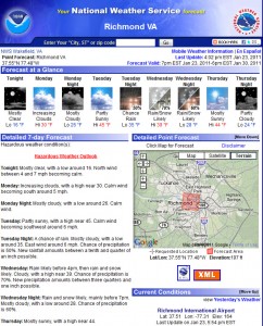
It looks like a potentially big rain storm, with a brush of wintry precipitation might be the best bet for Metro Richmond at this point. While the weather models still vary the storm in it’s track and location, the absence of cold air will make it difficult to see much snow along I-95. Monday and Tuesday will prove interesting to see how the forecast pans out for this system. The current NWS Forecast follows:
NWS Forecast as of 1/21/2010:
Monday Night: A chance of snow. Cloudy, with a low around 27. Chance of precipitation is 30%.
Tuesday: A chance of rain, snow, and sleet. Cloudy, with a high near 37. Chance of precipitation is 50%.
Tuesday Night: Rain likely. Mostly cloudy, with a low around 29. Chance of precipitation is 60%.
Wednesday: A chance of rain and snow showers. Mostly sunny, with a high near 43. Chance of precipitation is 40%.
The big question at this point is what type of precipitation will fall in Central Virginia. This will be determined by the storm track, the location of the high pressure in the northeast and how strong this storm will develop. The models still seem to be flip-flopping around on all three of these variables. As usual, it’ll come down to the wire to determine what type of event this will be for Central Virginia.
