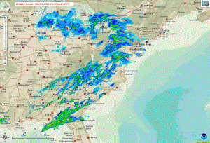
All posts by Ryan_R

January 17, 2013: Observations

Video of Event:


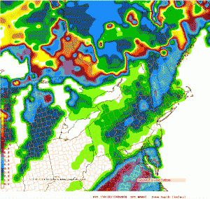
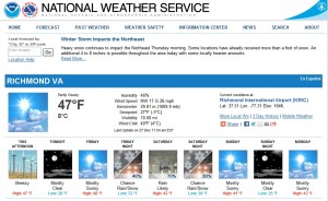
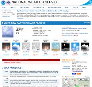
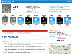
NWS forecast for 1/17/2013:

NWS Forecast, 1/17/13

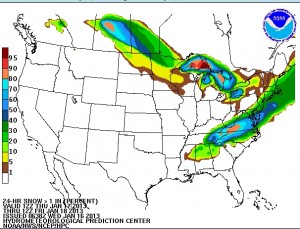
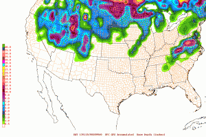
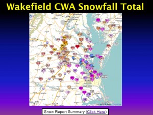
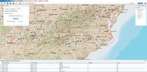
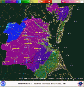
Current snowfall forecast:

NWS Snowfall Forecast, Morning of 1/17/13

Here is the latest warning for Richmond metro.

Winter Storm Warning

URGENT - WINTER WEATHER MESSAGE...UPDATED
NATIONAL WEATHER SERVICE WAKEFIELD VA
648 AM EST THU JAN 17 2013

MDZ021>023-VAZ060-065>083-085-172000-
/O.CON.KAKQ.WS.W.0001.130117T2300Z-130118T0600Z/
DORCHESTER-WICOMICO-SOMERSET-PRINCE EDWARD-MECKLENBURG-LUNENBURG-
NOTTOWAY-AMELIA-POWHATAN-CHESTERFIELD-HENRICO-KING WILLIAM-
KING AND QUEEN-ESSEX-WESTMORELAND-RICHMOND-NORTHUMBERLAND-
LANCASTER-BRUNSWICK-DINWIDDIE-PRINCE GEORGE-CHARLES CITY-NEW KENT-
MIDDLESEX-
INCLUDING THE CITIES OF...CAMBRIDGE...SALISBURY...CRISFIELD...
PRINCESS ANNE...FARMVILLE...SOUTH HILL...CREWE...
COLONIAL HEIGHTS...RICHMOND...TAPPAHANNOCK...LAWRENCEVILLE...
PETERSBURG...HOPEWELL
648 AM EST THU JAN 17 2013

...WINTER STORM WARNING REMAINS IN EFFECT FROM 6 PM THIS EVENING
TO 1 AM EST FRIDAY...

A WINTER STORM WARNING REMAINS IN EFFECT FROM 6 PM THIS EVENING
TO 1 AM EST FRIDAY.

* AREAS AFFECTED: THE VIRGINIA NORTHERN NECK AND MARYLAND
  EASTERN SHORE.

* HAZARDS: SNOW.

* ACCUMULATIONS: 3 TO 4 INCHES.

* TIMING: RAIN WILL QUICKLY CHANGE TO SNOW EARLY THIS EVENING AND
  BEGIN TO ACCUMULATE SHORTLY AFTER SUNSET. A BRIEF PERIOD OF
  HEAVY SNOWFALL THIS EVENING WILL CAUSE RAPID ACCUMULATIONS TO
  OCCUR. SNOW WILL END LATE TONIGHT.

* IMPACTS: SNOW...HEAVY AT TIMES...WILL ACCUMULATE ON ROADS AFTER
  SUNSET AND CREATE HAZARDOUS DRIVING CONDITIONS.

PRECAUTIONARY/PREPAREDNESS ACTIONS...

A WINTER STORM WARNING MEANS SIGNIFICANT AMOUNTS OF SNOW ARE
EXPECTED. STRONG WINDS ARE ALSO POSSIBLE. THIS WILL MAKE TRAVEL
VERY HAZARDOUS OR IMPOSSIBLE."

NWS Final Snow Totals

NWS Snow Total Map
NWS Snow Total Map

My Report (Church Hill):

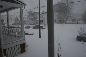
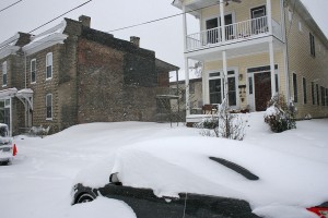
* Place – Time: Church Hill, 11:00 AM (1/18/2013) *After the Event Update*
* Temperature: 33-37, During Storm Event
* Dewpoint: 33-37, During Storm Event
* Relative Humidity: 100%
* Pressure: N/A
* Trends: N/A
*Winter Weather Watch/Warning/Advisory: Watch & Warning
* Road Conditions: All roads had snow cover during the event. The morning after the event, secondary roads remained slushy. Most major roads passable.
* Precipitation Description: Light, moderate and sometimes brief periods of heavy snow fell throughout the event. I observed thunder snow at the onset of the snow in western Chesterfield County (near St. Francis Hospital).
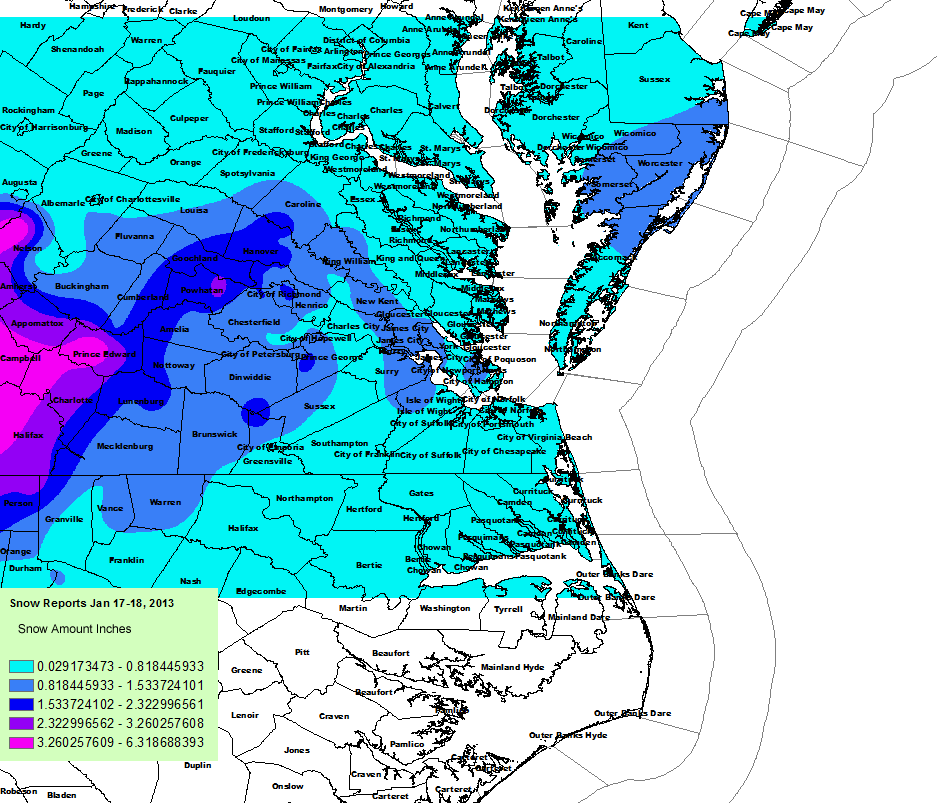
* Total Precip: 2.0″ of snow. Liquid Equivalent of 0.64″ fell during the event at the airport.
* Comments: A rain/snow mix started shortly after sunset on the 17th. The precipitation fell as light to occasionally moderate snow throughout the evening hours. Snow began to accumulate within one hour of transitioning to snow. The precipitation quickly changed to moderate and heavy snow by 6 PM where local roads began to get covered. One hour of moderate snow was reported in and around RIC airport around 9 PM. The snow began to taper off by 11:00 PM as it transitioned between rain and snow. Snow was very wet, with ratios close to 3.3:1. Precipitation was spurred by an upper level low that tracked up from northern Alabama to off the Virginia coast. This storm came at the end of a long week of rain that occurred each day, starting on 1/14/13. The airport reported 1.6” of snow.

Photo Gallery Link: Forthcoming

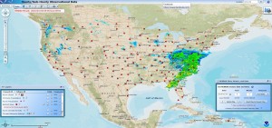
Links: http://www.erh.noaa.gov/akq/wx_events/Snow/jan17_2013/

January 17, 2013: Forecast for Rain to Snow

An upper level low riding along a stalled front to the south of Virginia could bring significant snowfall to all of Central Virginia tomorrow night. Hints at the potential for a winter storm were noted earlier in the week in some of the major weather models. Model disagreements were based on the timing of the cold air arrival and how much moisture would overspread into Central Virginia. Both NAM and GFS point to the possibility of significant snowfall amounts for tomorrow night. Current thoughts from Wakefield include:

.SHORT TERM /6 AM THURSDAY MORNING THROUGH FRIDAY/…
STRONG MID/UPPER LOW WILL LOCATE OVER THE LOWER MS VALLEY THURSDAY
MORNING AS THE SFC LOW STRENGTHENS ALONG THE STALLED BOUNDARY.
RAIN WILL BE ONGOING ACROSS THE PIEDMONT INTO SRN VA IN AREA OF
ISENTROPIC LIFT/DIVERGENCE ALOFT. STRONG DYNAMICS AND ABUNDANT
MOISTURE WILL ACCOMPANY THE UPPER LOW/PV ANOMALY AS IT LIFTS OUT
OF THE DEEP SOUTH AND INTO THE MID ATLANTIC THURSDAY AFTERNOON.
PRECIP WATERS WILL BE NEARLY ONE INCH WITH HIGH RH VALUES IN THE
IMPORTANT DGZ. SHARP HEIGHT FALLS WILL RESULT IN STRONG
FRONTOGENETIC FORCING AT THE SFC THURSDAY AFTERNOON AS A 200+ KT
JET EXISTS ACROSS THE NE. THIS WILL LEAD TO WIDESPREAD
RAIN…POSSIBLY HEAVY AT TIMES…OVER MUCH OF THE AFTERNOON
ACROSS THE ENTIRE FA. THE STRONGEST FRONTOGENETIC
FORCING/DIVERGENCE ALOFT WILL LOCATE OVER THE WRN AND NRN
FA…WHERE THE HIGHEST QPF AMOUNTS WILL OCCUR.

THE UPPER LEVEL SHORTWAVE WILL PHASE WITH THE NRN STREAM TROUGH
THURSDAY EVENING AS COLD SFC HIGH PRESSURE EXPANDS EWD FROM THE
GREAT PLAINS. AS THE SFC LOW TRACKS SOUTH OF THE FA THURSDAY
EVENING/OVERNIGHT…COLD AIR WILL ALLOW TEMPS TO DROP RAPIDLY
ALONG THE NRN PERIPHERY OF THE PRECIP. COLD AIR WORKING INTO THIS
DYNAMIC OF A SYSTEM WILL RESULT IN A QUICK CHANGE OVER TO SNOW
LATE THURSDAY AFTERNOON…FIRST ACROSS THE NW. HAVE GONE UNDER
MODEL GUIDANCE ON SNOW ACCUMULATIONS BASED ON THE ANTECEDENT
RAINFALL/MILD WEATHER WHICH HAS KEPT GROUND TEMPERATURES WARM.
HOWEVER…STRONG UVM IN THE DGZ WILL ALLOW FOR LARGER FLAKES AND
HEAVIER SNOWFALL RATES. THIS WILL HELP SNOW ACCUMULATE REGARDLESS
OF THE WARM GROUND CONDITIONS. ANOTHER THING TO OVERCOME IS LOW
LEVEL TEMPS HOVERING RIGHT AROUND FREEZING…TO SLIGHTLY ABOVE.
HAVE GONE UNDER MODEL GUIDANCE ON TEMPS TOMORROW EVENING AS PRECIP
FALLING INTO THE LOWER LEVELS WILL HELP COOL THE LOW LEVELS. AS
THE LOW PUSHES OUT OVER THE WATERS AND INTENSIFIES AS IT LIFTS
NE…COLD AIR WILL CONTINUE TO MOVE TO THE SW ALLOWING RAIN TO
CHANGE OVER TO SNOW ALL THE WAY TO THE COAST BY LATE THURSDAY
NIGHT/EARLY FRIDAY MORNING. AS DRY/COLD W/NW FLOW WORKS INTO THE
REGION…PRECIP WILL END QUICKLY NW TO SE THURSDAY NIGHT/EARLY
FRIDAY MORNING…UNDER CLEARING SKIES. WHEN ALL IS SAID AND
DONE…SNOWFALL AMOUNTS WILL RANGE FROM AROUND 4 TO 5 INCHES IN
THE NW TO HALF AN INCH ACROSS SE VA/NE NC. LOCATIONS ALONG THE
COAST WILL REMAIN WARM ENOUGH FOR LITTLE…IF ANY…SNOWFALL
ACCUMULATIONS. WITH THE POSSIBILITY OF WARNING CRITERIA BEING MET
(SREF PROBABILITIES OF >4 INCHES EXCEEDS 50 PCT)…HAVE OPTED TO
ISSUE A WINTER WEATHER WATCH AS OPPOSED TO A WINTER WEATHER
ADVISORY. ANOTHER THING TO CONSIDER IN THE HIGHLY DYNAMIC SYSTEM
IS PRECIP BANDING. STRONG FRONTOGENETIC FORCING AND SLIGHTLY
NEGATIVE SAT GEO POT VORT INDICATE BANDING WILL BE POSSIBLE AND
SOMETHING TO WATCH. BANDING WILL LEAD TO LOCALLY HIGHER SNOWFALL
AMOUNTS. GRASSY SURFACES WILL SEE THE MOST SNOWFALL WITH SOME
ACCUMULATION ON AREA ROADS AND HIGHWAYS. TOTAL QPF AMOUNTS WILL
RANGE FROM AN INCH TO AN INCH AND A HALF…WHICH ON ALREADY
SATURATED SOILS MAY LEAD TO ADDITIONAL HYDRO CONCERNS. A FLOOD
WATCH MAY BE NEEDED.

STRONG CAA ON FRIDAY (850 TEMPS FALL TO -7 TO -9C AND LOW LEVEL
THICKNESSES FALL OVER 20 M) AND AN EXISTING SNOW PACK WILL PREVENT
TEMPS FROM REACHING 40 ANY MANY LOCALES. WHILE SKIES WILL FINALLY
CLEAR FOR THE FIRST TIME IN SEVERAL DAYS…NORTHWEST WINDS 10 TO
15 MPH…STRONGER NEAR THE COAST…WILL MAKE IT FEEL EVEN COLDER.

Some other images of the possible storm:

HPC Snow Probability


0Z NAM Snowfall Predicition, 1/16/2013
0Z GFS Snowfall Predicition, 1/16/2013
6Z GFS Snowfall Predicition, 1/16/2013
12Z GFS Snowfall Predicition, 1/16/2013

December 29, 2012: Observations

No signs of winter appeared with this storm system for metro Richmond. Rain began early in the morning and tapered off by 11 AM. About 0.15″ of rain fell during the event with tempratures hovering between 37-39 degrees. Snow fell to the north and west of Richmond, mainly from Charlottesville and DC north.

Signs point to another possible storm system aimed at the area between January 2nd -4th. I’ll post a forecast thread tomorrow to discuss the possibilities.

December 29, 2012: Forecast for Snow to Rain

A rather complex storm system may impact the area on Saturday (December 29, 2012) that could bring a mixed bag of precipitation, mostly in the form of rain. However, there is a chance of snow for the area, as noted in the current NWS forecast:

NWS Forecast for 12/29/12

If this event pans out, this would be our first observation of snow for the season. It could also be our first chance for accumulating snow as well. More discussion about this event is detailed below in the NWS extended discussion:

.SHORT TERM /6 PM THIS EVENING THROUGH SATURDAY NIGHT/…
WINDS WILL SLOWLY SUBSIDE THIS EVENING AS PRES GRADIENT
SLACKENS…ALTHOUGH WILL STAY BREEZY ON THE ERN SHORE THROUGH THE
EVENING. OTHERWISE…HIGH PRESSURE SLIDES OFF THE COAST BY LATER
FRI AND THE REGION WILL RESIDE UNDER A MOSTLY CLEAR SKY ONCE AGAIN
THU NIGHT AND FRIDAY. EARLY MORNING LOW TEMPS SHOULD BE COLDER FRI
MORNING WITH READINGS IN THE MID 20S TO MID 30S AND HIGHS NEAR
NORMAL IN THE UPPER 40S TO AROUND 50 FRI.

THE NEXT LOW PRESSURE SYSTEM SLATED TO AFFECT THE MID ATLANTIC
STATES WILL BEGIN TO DEVELOP IN THE GULF COAST STATES FRI NIGHT
AND TRACK NE TWD THE REGION OVERNIGHT INTO EARLY SAT MORNING. MID-
UPPER LEVEL FLOW IS FAIRLY PROGRESSIVE INITIALLY SO THE SFC LOW
DOES NOT INTENSIFY THAT MUCH FRI NIGHT INTO SAT MORNING.
HOWEVER…OVERRUNNING PRECIP IS EXPECTED TO SPREAD ACROSS THE
REGION FROM SW TO NE EARLY SAT MORNING. WHILE THERE IS THE LACK OF A
COLD AIR WEDGE…TEMPS SHOULD HAVE NO PROBLEM FALLING NEAR
FREEZING BEFORE CLOUDS MOVE IN AND PREVENT THE ATMOSPHERE FROM
COOLING FURTHER. WITH THIS IN MIND…PRECIP MAY START AS ALL SNOW
IN FAR NW ZONES WITH A RAIN/SNOW TRANSITION ZONE TO ALL RAIN OVER
SE AREAS. IT DOES LOOK RATHER LIGHT INITIALLY SO ACCUMULATIONS
WOULD BE LIGHT. PRECIP IS EXPECTED TO BECOME ALL RAIN BY LATE
MORNING AS TEMPS WARM WELL ABOVE FREEZING…BUT HAVE GONE BELOW
GUIDANCE FOR HIGHS…MAINLY 40-45…UPR 40S TO LWR 50S FAR SE
VA/NE NC.

THE CHALLENGING PART OF THE FCST COMES SAT NIGHT…HOW FAST DOES
COLDER AIR COME IN FROM THE NW AND HOW RAPIDLY DOES THE SFC LOW
INTENSIFY? NOTE THAT LATEST 00Z ECMWF SHOWS RAPID INTENSIFICATION
OF THE SFC LOW AND KEEPS IT CLOSER TO THE COAST DUE TO MORE
AMPLIFICATION OF THE UPPER TROUGH. THIS TRACK WOULD POTENTIALLY
LEAD TO SOME ACCUMULATING SNOW IN MAINLY NE PORTIONS OF THE CWA. GFS
IS WEAKER/SLOWER TO BRING IN COLD AIR…AND THE SFC LOW TRACKS
FARTHER OFF THE COAST W/ LITTLE MORE THAN A SMALL CHC FOR LIGHT
SNOW SHOWERS SAT EVENING/EARLY SUNDAY ACRS MAINLY THE ERN SHORE.
THE LATEST GFS ENSEMBLE SHOWS A LARGE SPREAD ON THE WEST SIDE OF
THE GFS TRACK SO THE ECMWF MAY BE ON TO SOMETHING…SO FCST WILL
TAKE THIS INTO ACCOUNT AND SIDE CLOSER TO THE COLDER SCENARIO.
GRIDDED FCST HAS CHANGEOVER BY 00Z NW…TO THE COAST BY
MIDNIGHT…WHICH IS FAIRLY CLOSE TO THE 1295 M 1000-850 THICKNESS
VALUES FROM THE ECMWF.

December 26-27, 2012: Observations

The major winter storm (termed “Euclid” from TWC) that churned through yesterday brought a round of heavy rain to central Virginia. No snow or sleet was reported at the airport. In addition, I did not see any sleet or snow during the beginning at the event. My location in Church Hill received 1.24″ of rain yesterday. As of today, we still do not have any snow observations for the season in Richmond.

Snowstorm Profile: January 30th Storm of 2010

Snowstorm Profile

Name: January 30th Storm of 2010

Date: January 30, 2010

Precipitation Observed: 12.25” (Church Hill)

RIC Airport Total Snowfall Observation: 9.5”

Precipitation Type: Snow


NWS Radar for 1/30/2010

The January 30th, 2010 snowstorm will mark the fourth winter storm to be profiled in a series of articles to be posted on our blog. We hope you find these weather event musings entertaining and factual. These articles will portray some of the most memorable snow events that Russ and I have lived through while residing in Richmond, Virginia.


Snowstorm Profiles:

Blizzard of 1996

March 1st Storm of 2009

December 18-19th Storm of 2009 (Peacock Day Storm)

Before the Storm: The winter of 2009-2010 was already off to significant start with the December 18/19th snowstorm. Considering ourselves lucky with the storm in December, there was an element of disbelief that another large storm was set to hit the area in late January. By Thursday, January 28th, the NWS had issued a winter storm watch for Metro Richmond warning of a snow event that could drop 5 to 10 inches of snow. As Saturday approached, signs of the storms power and potency became apparent.


Synoptic Overview of Storm System: A low pressure system developed over the Gulf Coast spawned a widespread snow event from Tennessee to the Delmarva peninsula. The first reference link below provides a much more detailed and analytical write-up of the system’s dynamics.

Heavy snowfall and low visibility from the house.

The Main Event: This event started just before sunrise on Saturday morning, lasting until late in the evening in Metro Richmond. One of the most notable things about this storm is how cold the event turned out to be. From the onset, tempreatures were in the low 20’s and never got above 29 degrees the entire day. There were no mixing issues in this storm, everything that fell was pure snow. Since it was the weekend, I didn’t have to work so I enjoyed the snowfall all day long. Russ and I ventured down to Libby Hill Park around 11 AM to do some sledding. Around 5-6″ of snow had fallen by then. This time period also had the peak snowfall rates for this storm. Visibility was incredibly low and the wind was constantly gusting in the 10-15 MPH range out of the north. The walk home from the park that afternoon was a painful one since the snow was driving in on a north wind, we were walking northbound.

Small drifts of snow along North 29th Street.

The snowfall rate easily approached 1-1.5″ an hour at times that morning. There were points in the morning that near whiteout conditions occurred. It was some of the most incredible heavy day snowfall I’ve ever seen. Overall, snowfall rates coupled with the wind made it feel miserable outside.

Wakefield CWA Snowfall Totals

Snow quickly tapered off the night after the storm. When all was said and done, we had a remarkable 12.25″ of snow in Church Hill! Since owning a home here (Nov. 2007), this is the largest single snow event I’ve witnessed at this location.

Snowfall RSI Map for Event


My official measurement did not coincide with the official measurement at the airport. Snow measurements were taken in several open spots around the block.


Video of Event (in Church Hill):

Other Resources/Links:


1)      http://www.erh.noaa.gov/akq/wx_events/winter/Jan32010.pdf

2)     http://richmondcitywatch.com/612/modules/gallery2/main.php?g2_itemId=991 (Link to my personal photo gallery)

December 26-27, 2012: Forecast for Snow/Sleet to Rain

The day after Christmas, a complex and potentially potent storm system will develop over the southern United States and track to the northeast. The low will redevelop near Richmond and then track northeastward towards across the Delmarva peninsula. The forecast for this system seemed more promising about 8-10 days out with a higher chance of rain and snow for the Richmond metro area. Today, the weather models have shifted and focused the brunt of the winter weather to interior portions of the Ohio Valley, Mid-Atlantic and Northeast corridor (interior regions).

It’s worth mentioning this storm now since their is a small chance of Richmond’s having its first snowfall/sleet/freezing rain event of the season. The NWS has made mention of the snow/sleet potential for this storm system early Wednesday Morning.

NWS Forecast for 23223

As of today, we have not seen any wintry weather in Richmond. Here is to hoping that we can catch a few flakes or pellets from this system before it turns to rain (which could be as much as .75 – 1.5″ of rain).