Snowstorm Profile
Name: December 18-19th Storm of 2009 (Peacock Day Storm)
Date: December 18-19, 2009
Precipitation Observed: 7.5” (Church Hill)
RIC Airport Total Snowfall Observation: 7.4”
Precipitation Type: Primarily Snow, followed by Sleet & Freezing Rain/Drizzle

The December 18-19th, 2009 snowstorm will mark the third winter storm to be profiled in a series of articles to be posted on our blog. We hope you find these weather event musings entertaining and factual. These articles will portray some of the most memorable snow events that Russ and I have lived through while residing in Richmond, Virginia.
Snowstorm Profiles:
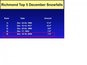
Before the Storm: With the early March storm of 2009, expectations were running high for the start of the winter season of 2009-2010. By Thursday, December 17th, the NWS had issued a winter storm watch for Metro Richmond warning of a snow event that could drop 6 to 12 inches of snow. The anticipation of experiencing a major winter storm before the actual start of the astronomical winter season was rare. To put how rare December snowstorms are in Richmond, the NWS compiled a nice graphic ranking this storm to other December snowfalls:
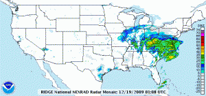
Synoptic Overview of Storm System: A low pressure system developed over the Gulf Coast spawned a widespread snow event from north Georgia to the coastal sections of Maine. The first reference link below provides a much more detailed and analytical write-up of the system’s dynamics.
Video of Event from Church Hill (My Home):
The Main Event: This event started just after sunset on Friday, December 18th, lasting until the early morning hours of December 19th in Metro Richmond. Russ & I were anticipating this event several days before the first flake fell from the sky. I still have a fond memory of looking for the first flakes to fall while sitting at work. Just as it was time to leave work, snow began falling. The snow rate intensified at quick clip from 5 to 8 PM. Snow continued to fall at a high rate with little in the way of wind being observed through most of the evening hours. Prior to 11 PM on the 18th, the most intense part of the storm hit. The wind picked up slightly and the snowfall rate accelerated to over an inch an hour. Near midnight, Russ and I found measurements of snow in a nearby field on M Street between 8-9”. Shortly thereafter, the precipitation began to slowly wind down and changed from snow to sleet, freezing rain and even drizzle for the remainder of the night. By 6 AM on the 19th, the temperature rose to 33.6 degrees.
Snow intermittently fell the next day as the storm cranked up the coast towards New England. Between 4-6 PM on the 19th, we had a small batch of snow showers move in, giving us a light dusting of snow.
Again, Russ took some excellent video footage of the event that showed the intensity of the snowfall.
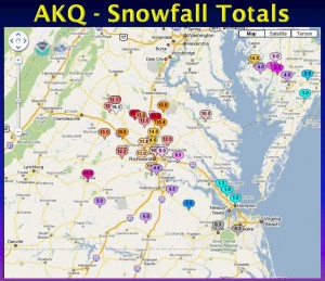
My official measurement coincided with the official measurement at the airport. Had the snow not changed over to sleet, freezing rain and drizzle, there is no doubt that we could have seen 8-10” from this storm in Church Hill. Areas to the north and west of town saw substantially more snow than Downtown Richmond.
Video of Event, Part 2 (in Church Hill):
Other Resources/Links:
1) http://www.erh.noaa.gov/akq/wx_events/winter/20091218/2009Dec18_19_Winter_Storm.pdf
http://www.612.richmondcitywatch.com/modules/gallery2/main.php?g2_itemId=917(Link to my personal photo gallery)

