Snowstorm Profile
Name: January 30th Storm of 2010
Date: January 30, 2010
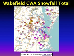
Precipitation Observed: 12.25” (Church Hill)
RIC Airport Total Snowfall Observation: 9.5”
Precipitation Type: Snow
-
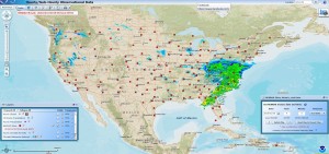
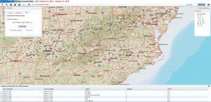
NWS Radar for 1/30/2010
The January 30th, 2010 snowstorm will mark the fourth winter storm to be profiled in a series of articles to be posted on our blog. We hope you find these weather event musings entertaining and factual. These articles will portray some of the most memorable snow events that Russ and I have lived through while residing in Richmond, Virginia.
Snowstorm Profiles:
December 18-19th Storm of 2009 (Peacock Day Storm)
Before the Storm: The winter of 2009-2010 was already off to significant start with the December 18/19th snowstorm. Considering ourselves lucky with the storm in December, there was an element of disbelief that another large storm was set to hit the area in late January. By Thursday, January 28th, the NWS had issued a winter storm watch for Metro Richmond warning of a snow event that could drop 5 to 10 inches of snow. As Saturday approached, signs of the storms power and potency became apparent.
Synoptic Overview of Storm System: A low pressure system developed over the Gulf Coast spawned a widespread snow event from Tennessee to the Delmarva peninsula. The first reference link below provides a much more detailed and analytical write-up of the system’s dynamics.
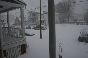
The Main Event: This event started just before sunrise on Saturday morning, lasting until late in the evening in Metro Richmond. One of the most notable things about this storm is how cold the event turned out to be. From the onset, tempreatures were in the low 20’s and never got above 29 degrees the entire day. There were no mixing issues in this storm, everything that fell was pure snow. Since it was the weekend, I didn’t have to work so I enjoyed the snowfall all day long. Russ and I ventured down to Libby Hill Park around 11 AM to do some sledding. Around 5-6″ of snow had fallen by then. This time period also had the peak snowfall rates for this storm. Visibility was incredibly low and the wind was constantly gusting in the 10-15 MPH range out of the north. The walk home from the park that afternoon was a painful one since the snow was driving in on a north wind, we were walking northbound.
The snowfall rate easily approached 1-1.5″ an hour at times that morning. There were points in the morning that near whiteout conditions occurred. It was some of the most incredible heavy day snowfall I’ve ever seen. Overall, snowfall rates coupled with the wind made it feel miserable outside.
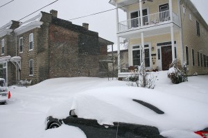
Snow quickly tapered off the night after the storm. When all was said and done, we had a remarkable 12.25″ of snow in Church Hill! Since owning a home here (Nov. 2007), this is the largest single snow event I’ve witnessed at this location.
My official measurement did not coincide with the official measurement at the airport. Snow measurements were taken in several open spots around the block.
Video of Event (in Church Hill):
Other Resources/Links:
1) http://www.erh.noaa.gov/akq/wx_events/winter/Jan32010.pdf
2) http://richmondcitywatch.com/612/modules/gallery2/main.php?g2_itemId=991 (Link to my personal photo gallery)