Snowstorm Profile
Name: March 1st Storm of 2009
Date: March 1-2, 2009
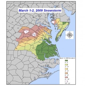
Precipitation Observed: No Official Measurement* (Church Hill), Western Chesterfield – 10″ (unofficially)
RIC Airport Total Snowfall Observation: 6.3”
Precipitation Type: Snow
The March 1st, 2009 snowstorm will mark the second winter storm to be profiled in a series of articles to be posted on our blog. We hope you find these weather event musings entertaining and factual. These articles will portray some of the most memorable snow events that Russ and I have lived through while residing in Richmond, Virginia.
Snowstorm Profiles:
Before the Storm: As a snow lover living in Richmond, you are used to either 1) being bypassed by large snow events to the north and west of town or 2) a victim of overforecastation by the local media and sometimes the National Weather Service (NWS). Overforecastation is a term I define as “the over prediction of snow, even in small amounts.” Russ and I can recount several potential snow events in the past where the forecast ended up busting with either mixed-bag or starry-night surprise. Richmond’s placement in the coastal plain adjacent to the Appalachian Mountains creates unique forecasting challenges when it comes down to snow and ice events. Forecasting snow in Richmond will likely always be a tricky proposition, no matter which way you look at it.
Adding to what Ryan said, forecasting any winter storm in Richmond is always very difficult. It is often not known what the storm should produce until about 36-24 hours prior to the arrival, or less. Richmond is often plagued by snow/mix/rain line location problems (the rain/snow line is often right on top of Richmond, setting up right along I-95). A 10-20 mile shift of this could mean all snow or snow/sleet mix, or snow to rain changeover. It is very frustrating. I’ve lived in the Richmond metro area all my life (since 1982) and this creates extremely frustrating outcomes more often than not.
I’ve lived in Richmond since the summer of 2005. Between 2005 and 2009, Richmond was in a bona fide snow drought. I have a vague memory of a few minor snow events occurring during this time period, nothing really exceeding much more than an inch or two of snow. A check of the climate data from the Richmond Airport verifies a few years of below-average seasonal snowfall totals:
|
2005-06 |
8.50” |
|
|
2006-07 |
1.30” |
|
|
2007-08 |
0.80” |
|
|
2008-09 |
6.60” |
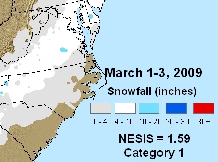
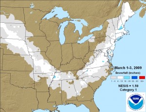
Synoptic Overview of Storm System: A low pressure system swinging from the lower Tennessee Valley up the eastern seaboard spawned a widespread snow event from the Southeast all the way up into northern New England. The first reference link below provides a much more detailed and analytical write-up of the system’s dynamics.
Video of Event from Church Hill (My Home):
The Main Event: This event started in the late evening hours of February 28th, lasting until the early morning hours of March 1st in Metro Richmond. The snow came down at quick clip for several hours. I remember being a little surprised by the intensity and seasonal lateness of this storm. March snowstorms typically don’t occur in Metro Richmond. Late in the winter season, shots of cold air and moisture rarely combine to create a pure snow event. We are much more likely to see a mixed precipitation event or a snow to rain event. In this instance, cold air held on strong and we were able to pick up all snow from this event.
*Western Chesterfield: The only differences in the effects of this storm for the northwestern part of Chesterfield was that slightly heavier banding set up leading to an unofficial measurement of 10″ of snow. Also, a secondary, wrap-around band of snow set up late overnight into the early morning of the 2nd. This, mainly light snow, formed around 12AM and remained stationary until it dissipated around 8-9AM on the 2nd. As Ryan stated, this storm was unusual for several reasons. First, it was a late season snow storm. Second, for Richmond, we rarely see ALL snow from any major winter storm. We had no mixing from what I recall. Third, the amount of snow was, for Richmond, a fairly large amount. The NESIS ranked this as 42nd on the list.

See the radar loop of the event over at the link below
The video that Russ took during the event does a nice job showing the intensity of the snowfall.
 The snowfall total at the airport was the largest snowfall measurement since the January 2002 snowstorm. The storm officially ended the “unofficial” snow drought Richmond had been stuck in since 2002**.
Video of Event, Sledding in Church Hill:
* No official measurements were taken at my home in Church Hill. However, my memory and storm photos place the snowfall total in the range of 6-8 inches. (I, Russ, recall about 9.5″ at this location)
** The last time a total of more than 6” was reported at the RIC Airport prior to the March 1, 2009 storm occurred on January 3, 2002 with 7.7” (a daily record as well).
Other Resources/Links:
1) http://nws.met.psu.edu/severe/2009/01Mar2009FC.pdf
2) http://www.612.richmondcitywatch.com/modules/gallery2/main.php?g2_itemId=790 (Link to my personal photo gallery)
3) http://www.erh.noaa.gov/akq/wx_events/winter/20090301/WBCPNSAKQ_20090301.txt (NWS Storm Reports)
4) http://www.erh.noaa.gov/akq/wx_events/winter/20090301/ (NWS Map/Snow Totals)
5) http://www.erh.noaa.gov/akq/wx_events/winter/20090302/snow20090302.htm (NWS Map)
