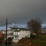
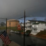
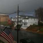
Below are a few photos from a squall line that rolled through on December 27, 2011. It was a potent batch of rain and wind that was quickly followed by a double rainbow.


Below are a few photos from a squall line that rolled through on December 27, 2011. It was a potent batch of rain and wind that was quickly followed by a double rainbow.
Grim. No real significant storm threats loom on the horizon for Metro Richmond over the next week. A storm near Christmas may drop some precipitation, but it looks likely that tempratures will be too warm to support wintry precipitation. Bummer.
In the hopes of seeing some more chances of snow emerge in the next few weeks, I’ll post this handy summary guide that tallies the snow totals for the Richmond Airport since 1898. Enjoy!

This storm rapidly moved through the area the day of December 8th. No winter precipitation fell in Richmond from this storm event. However, a 50+ MPH gust accompanied the squall line that marched through with the main batch of precipitation.
The first substantial chance of winter weather might be heading our way tomorrow night. The various models seem to point to an accumulating snow event along the Appalachian mountains. In Richmond, the NWS still has the metro area in 100% rain. Areas like Short Pump and Powhatan have a slight chance of the precipitation changing to snow.
The chance of accumulating snow for Richmond remains very low. However, we could see a rain to snow changeover on the tail end of the precipitation shield. This scenario will likely preclude any meaningful accumulation. It will be worth watching to see how the event pans out for Metro Richmond.
18Z NAM

12/7/2011 Forecast per TWC

This am it got down to 26.1*. Good to see lows starting to dip into the mid 20’s. RIC reached 29*, the first sub-30* of the season.
http://WWW.wunderground.com/weatherstation/WXDailyHistory.asp?ID=KVACHEST23/

So far, November has been quiet on the wx front. It’s been a bit chiily with lows in the 30’s and a few days a showers.
Longer trends keep the cool air dominant in Central VA, with highs mainly in the 60’s and lows in the mid-upper 30’s.
Meteorological winter starts December 1st, and early forecasts shows normal temps and precip for Central VA and the Mid-Atlantic.
I’ll go ahead and make my guess for RVA’s first inch of snow…..January 3rd. My guess for Winter 11-12 snow total….16.5″ of the precious white stuff.
More updates as winter inches closer…Expect more posts about potential winter storms, winter storm obervations, and pictures, data, and other goodies. Bookmark this blog!
Weather Event: Blizzard of 1996
Location of Observation: Midlothian, Virginia
Precipitation Type: Heavy Snow
Dates of Observation: January 6-7, 1996
Official Observation/Storm Total from RIC: 11.5″
Synoptic Overview of Storm System: The storm formed in the Gulf of Mexico the morning of the 6th, moved south of Alabama the evening of the 6th, reached Savannah, Georgia the morning of the 7th, Cape Hattaras the evening of the 7th, just east of the Delaware Bay the morning of the 8th, and the southern New England coastal waters the evening of the 8th. This was a classic storm track for heavy snow.
Personal Observations & Memories: Besides the January 2000 snowstorm, some of my best snow memories were created by this storm. I still remember when the first flakes began to fall with this storm system. The air was cold from the onset so all of the snow stuck right away to the grass and pavement. Snowfall intensity remained fairly light through the early afternoon until about nightfall. By the evening, the brunt of the storm was moving into the area. Incredibly heavy snow began falling from sunset until almost 4 AM in the morning. I ventured out with friends in the heavy snowfall, amazed at how quickly the snow piled up. It come as a disappointment later on in the evening when the snow fall began to taper off and change to sleet. If my memory serves me correctly, the sleet lasted for a few hours, compacting the 10-12 inches that had fallen already. Wrap around snow came to the rescue later on the 7th, adding another shot of 6-10 inches on what had already fallen. Unofficial measurements taken by me at the time easily pegged this storm between 18-19″ of snow in Central Chesterfield. it would be a couple days later where a second system left Central Virginia with 3-6″ of more snow on top of what had already fallen.
At the time of this storm, I was 13 years old and in 8th grade. This storm hit metropolitan Richmond not long after school resumed from Winter Break. Schools ended up closing for nearly 2 weeks (8.5 days total, eight full days off with 2 school days with delayed openings) and most of the midterm exams canceled due to the snowfall. As a student, I was elated to have all of my exams cancelled!
Images:


Links:
*Update: 1/23/2011
It looks like a potentially big rain storm, with a brush of wintry precipitation might be the best bet for Metro Richmond at this point. While the weather models still vary the storm in it’s track and location, the absence of cold air will make it difficult to see much snow along I-95. Monday and Tuesday will prove interesting to see how the forecast pans out for this system. The current NWS Forecast follows:

NWS Forecast as of 1/21/2010:
Monday Night: A chance of snow. Cloudy, with a low around 27. Chance of precipitation is 30%.
Tuesday: A chance of rain, snow, and sleet. Cloudy, with a high near 37. Chance of precipitation is 50%.
Tuesday Night: Rain likely. Mostly cloudy, with a low around 29. Chance of precipitation is 60%.
Wednesday: A chance of rain and snow showers. Mostly sunny, with a high near 43. Chance of precipitation is 40%.
The big question at this point is what type of precipitation will fall in Central Virginia. This will be determined by the storm track, the location of the high pressure in the northeast and how strong this storm will develop. The models still seem to be flip-flopping around on all three of these variables. As usual, it’ll come down to the wire to determine what type of event this will be for Central Virginia.
NWS Forecast, 1/20/2011:
This Afternoon: Increasing clouds, with a high near 45. South wind around 6 mph.
Tonight: A chance of rain before midnight, then rain and snow likely. Cloudy, with a low around 34. Southeast wind 5 to 8 mph becoming west. Chance of precipitation is 60%. Little or no snow accumulation expected.
Current Radar:

TWC Forecast:

The next possible winter weather event for Central Virginia appears to be coming from a low-pressure system that will develop along a cold front Thursday night into Friday morning. As of this morning (1/18/2011), NWS and NBC12 are forecasting primarily rain for this event. Some of the weather models as of noon today are still bullish on pushing snow into the area. Richmond remains close to the 32-degree line. While QPF from this system remains light (around 0.10″), the possibility exists for Central Virginia to see some light snow on the tail end of this event. As this low hits the coast, there is the possibility that it strengthens and develops into a Miller B storm for the Northeast and New England.
12Z NAM:

12Z GFS
