Deprecated: Optional parameter $selected declared before required parameter $args is implicitly treated as a required parameter in /home/richmon/domains/richmondcitywatch.com/public_html/rvawx_test/wp-content/plugins/archives-calendar-widget/arw-settings.php on line 178
Deprecated: Optional parameter $view declared before required parameter $args is implicitly treated as a required parameter in /home/richmon/domains/richmondcitywatch.com/public_html/rvawx_test/wp-content/plugins/archives-calendar-widget/arw-widget.php on line 480
Deprecated: Optional parameter $archiveMonth declared before required parameter $args is implicitly treated as a required parameter in /home/richmon/domains/richmondcitywatch.com/public_html/rvawx_test/wp-content/plugins/archives-calendar-widget/arw-widget.php on line 480
Warning: Trying to access array offset on value of type bool in /home/richmon/domains/richmondcitywatch.com/public_html/rvawx_test/wp-content/plugins/archives-calendar-widget/archives-calendar.php on line 64 News | RVAWX.com
What a bizarre January that was. No accumulating snow, sleet, ice or even grauple! 2.01″ of rain. 21 days with a high temp of 50* or greater. 10 days with a low above freezing (32*). A mean temp of 42.3*. Wow! The “Anti-Winter”. This may go on record, if February continues the trend, as one of Richmond’s warmest, least snowy ever. What a bummer for snow junkies…
As Jim Duncan tweeted recently, I’m ready to throw in the towel on this winter…
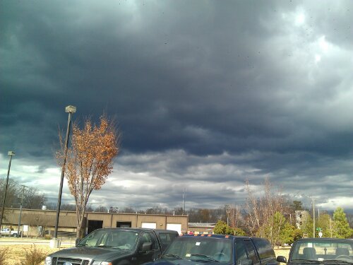
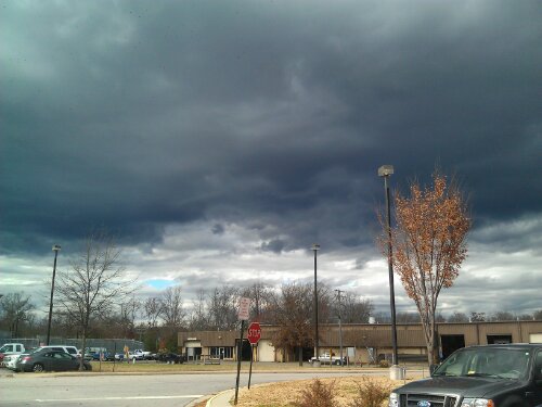
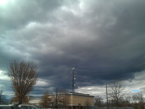
Some dark and scary Stratus clouds looming over Chesterfield. They are also ushering in a cold front that will drop temps and bring some gusty winds this evening.
Today through Wednesday night should be cloudy with patchy drizzle. More significant rain will come Tuesday night and into Wednesday. A thunderstorm is possible on Wednesday as well with the passing of a cold front.
The cold front will bring more seasonal temps from Thursday through next week, with highs in the upper 50’s to mid 60’s and lows in the upper 30’s to mid 40’s.
The long range models are hinting at a chilly start to December. More to come on that later…
So far, November has been quiet on the wx front. It’s been a bit chiily with lows in the 30’s and a few days a showers.
Longer trends keep the cool air dominant in Central VA, with highs mainly in the 60’s and lows in the mid-upper 30’s.
Meteorological winter starts December 1st, and early forecasts shows normal temps and precip for Central VA and the Mid-Atlantic.
I’ll go ahead and make my guess for RVA’s first inch of snow…..January 3rd. My guess for Winter 11-12 snow total….16.5″ of the precious white stuff.
More updates as winter inches closer…Expect more posts about potential winter storms, winter storm obervations, and pictures, data, and other goodies. Bookmark this blog!
URGENT - WINTER WEATHER MESSAGE
NATIONAL WEATHER SERVICE WAKEFIELD VA
311 PM EST WED DEC 15 2010
...SNOW...POSSIBLY MIXED WITH SLEET AND LIGHT FREEZING RAIN LATE
TONIGHT AND THURSDAY...
THE NATIONAL WEATHER SERVICE IN WAKEFIELD HAS ISSUED A WINTER
STORM WARNING FOR HEAVY SNOW...WHICH IS IN EFFECT FROM 4 AM TO 7 PM
EST THURSDAY. THE WINTER STORM WATCH IS NO LONGER IN EFFECT.
* ACCUMULATION...2 TO 5 INCHES OF SNOW.
* ICE AMOUNTS...A TRACE TO ONE TENTH OF AN INCH OF ICE IS
POSSIBLE...MAINLY TOWARD THE NORTH CAROLINA BORDER THURSDAY
AFTERNOON AND EVENING.
* TIMING: LATE TONIGHT THROUGH THURSDAY EVENING.
* IMPACTS: HAZARDOUS TRAVEL CONDITIONS.
12/15 9:00PM: Not much has changed in the past few hours in terms of the forecast. Some areas to the west had the snow totals increased to 3-7″
The main precip shield is still just west of the Apps, and, amazingly, it stretches NW up to Bismark!
Check out the excel spreadsheet at the link. I plan on working on a huge database covering every monthly report since 1982 for Richmond. Look for more info and ways to help soon.
12/11 NEWS:
– Added “News, Links and Favorites”, “RADAR Images”, “Real Time Weather Data”, and “RVAWX Archives” pages. Check out videos on the “Archives” pages (youtube viewable and downloadable HD versions for your preferences)
– Started “Event” posts for forecasts
– Started “OBS” posts for real time observation posting
– Much more to come as we expand and grow
– Keep an eye on the front page, we may be asking for volunteers to help with maps, forecasting and observation data
Current & Historical Weather Events in Richmond, Virginia