Deprecated: Optional parameter $selected declared before required parameter $args is implicitly treated as a required parameter in /home/richmon/domains/richmondcitywatch.com/public_html/rvawx_test/wp-content/plugins/archives-calendar-widget/arw-settings.php on line 178
Deprecated: Optional parameter $view declared before required parameter $args is implicitly treated as a required parameter in /home/richmon/domains/richmondcitywatch.com/public_html/rvawx_test/wp-content/plugins/archives-calendar-widget/arw-widget.php on line 480
Deprecated: Optional parameter $archiveMonth declared before required parameter $args is implicitly treated as a required parameter in /home/richmon/domains/richmondcitywatch.com/public_html/rvawx_test/wp-content/plugins/archives-calendar-widget/arw-widget.php on line 480
Warning: Trying to access array offset on value of type bool in /home/richmon/domains/richmondcitywatch.com/public_html/rvawx_test/wp-content/plugins/archives-calendar-widget/archives-calendar.php on line 64 Observation | RVAWX.com | Page 6
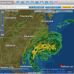
A line of showers moved through metro Richmond this morning with some gusty winds and brief heavy rain. No severe weather watches or warnings were issued for counties in the immediate vicinity of metro Richmond. As of 10 AM, Church Hill received 0.13″ of rain.
This storm rapidly moved through the area the day of December 8th. No winter precipitation fell in Richmond from this storm event. However, a 50+ MPH gust accompanied the squall line that marched through with the main batch of precipitation.
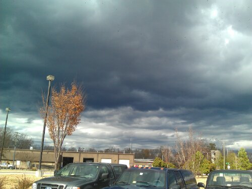
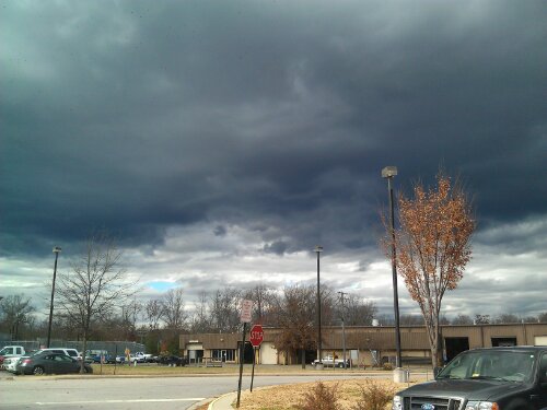
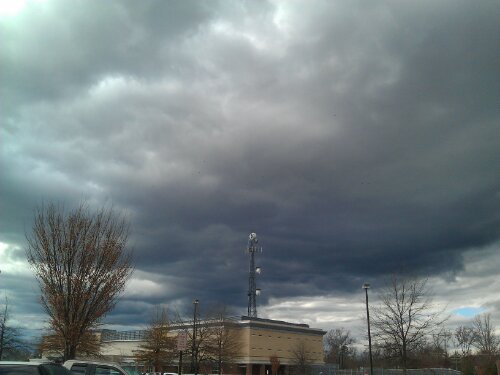
Some dark and scary Stratus clouds looming over Chesterfield. They are also ushering in a cold front that will drop temps and bring some gusty winds this evening.
Today through Wednesday night should be cloudy with patchy drizzle. More significant rain will come Tuesday night and into Wednesday. A thunderstorm is possible on Wednesday as well with the passing of a cold front.
The cold front will bring more seasonal temps from Thursday through next week, with highs in the upper 50’s to mid 60’s and lows in the upper 30’s to mid 40’s.
The long range models are hinting at a chilly start to December. More to come on that later…
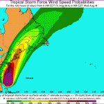
With near the intensity of Hurrican Isabel in 2003, Hurricane Irene pummelled central Virginia on August 27, 2011 with high winds and heavy rainfall. Power outages were extensive in Central Virginia. It was common for Dominion Power customers to be out of power between 2-8 days after the storm ended. In Church Hill, I was fortunate enough not to loose electrivity during the event.
I have a series of photos and videos from the event. I hope to add them to this post in the coming weeks to document this weather event.
In the meantime, a video that I took from Church Hill is posted below from the event:
This Afternoon: Increasing clouds, with a high near 45. South wind around 6 mph.
Tonight: A chance of rain before midnight, then rain and snow likely. Cloudy, with a low around 34. Southeast wind 5 to 8 mph becoming west. Chance of precipitation is 60%. Little or no snow accumulation expected.
One impressive statistic from the 2010 weather data that was recorded at my house was the highest amount of liquid rainfall accumulating in a 24-hour period. Signaling the end of summer and an extreme drought, my station recorded 3.36″ of rain in a single day. The radar loop from the day is impressive as well. The rain was spawned from the remnants of Nicole and a coastal low.
The forecast for tomorrow’s winter storm that is now hammering the southeast has changed substantially in the past few days. Hints of this winter storm were first seen in late December (see Wxrisk.com). About 3-5 days ago, there was the possibility that this storm could drop anywhere from 3-6″ of snow in Central Virginia. As the event comes closer to realization, the models have shifted the development of this low off the Virginia and Delmarva coast. Consequently, Central Virginia is forecast to be sparred the majority of precipitation from this event. The other major change in the forecast is the precipitation type. The development and proximity of the coastal low is projected to turn the snow into sleet and freezing rain for a large portion of Central Virginia tomorrow. Plain old rain may even mix in before the wrap-around moisture turns the precipitation back to snow. This will substantially cut down on any snowfall accumulation tomorrow. The NWS current forecast for “23223″ is for 0.5 – 1″ total of snow and ice. Winter Weather Advisories have also been posted this morning for the majority of Central Virginia in anticipation of the upcoming winter storm. Storm reports will be posted tomorrow morning as the event unfolds.