Deprecated: Optional parameter $selected declared before required parameter $args is implicitly treated as a required parameter in /home/richmon/domains/richmondcitywatch.com/public_html/rvawx_test/wp-content/plugins/archives-calendar-widget/arw-settings.php on line 178
Deprecated: Optional parameter $view declared before required parameter $args is implicitly treated as a required parameter in /home/richmon/domains/richmondcitywatch.com/public_html/rvawx_test/wp-content/plugins/archives-calendar-widget/arw-widget.php on line 480
Deprecated: Optional parameter $archiveMonth declared before required parameter $args is implicitly treated as a required parameter in /home/richmon/domains/richmondcitywatch.com/public_html/rvawx_test/wp-content/plugins/archives-calendar-widget/arw-widget.php on line 480
Warning: Trying to access array offset on value of type bool in /home/richmon/domains/richmondcitywatch.com/public_html/rvawx_test/wp-content/plugins/archives-calendar-widget/archives-calendar.php on line 64 Forecast Discussion | RVAWX.com | Page 8
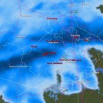
Our last chance for snow from this dynamic storm system is getting closer to reaching metro Richmond this afternoon and evening. Will we see heavy wet snow as forecasted by NWS? The radar looks promising as we recieve some thunderstorms first, followed by snow this evening!
It looks like a potentially big rain storm, with a brush of wintry precipitation might be the best bet for Metro Richmond at this point. While the weather models still vary the storm in it’s track and location, the absence of cold air will make it difficult to see much snow along I-95. Monday and Tuesday will prove interesting to see how the forecast pans out for this system. The current NWS Forecast follows:
NWS Forecast as of 1/21/2010:
Monday Night: A chance of snow. Cloudy, with a low around 27. Chance of precipitation is 30%.
Tuesday: A chance of rain, snow, and sleet. Cloudy, with a high near 37. Chance of precipitation is 50%.
Tuesday Night: Rain likely. Mostly cloudy, with a low around 29. Chance of precipitation is 60%.
Wednesday: A chance of rain and snow showers. Mostly sunny, with a high near 43. Chance of precipitation is 40%.
The big question at this point is what type of precipitation will fall in Central Virginia. This will be determined by the storm track, the location of the high pressure in the northeast and how strong this storm will develop. The models still seem to be flip-flopping around on all three of these variables. As usual, it’ll come down to the wire to determine what type of event this will be for Central Virginia.
The next possible winter weather event for Central Virginia appears to be coming from a low-pressure system that will develop along a cold front Thursday night into Friday morning. As of this morning (1/18/2011), NWS and NBC12 are forecasting primarily rain for this event. Some of the weather models as of noon today are still bullish on pushing snow into the area. Richmond remains close to the 32-degree line. While QPF from this system remains light (around 0.10″), the possibility exists for Central Virginia to see some light snow on the tail end of this event. As this low hits the coast, there is the possibility that it strengthens and develops into a Miller B storm for the Northeast and New England.
**While cold air has filtered into place over Central Virginia, it appears that this will primarily be a rain event for tonight into Wednesday morning. There may be a little sleet at the onset of the precipitation, but no accumulation is expected. All eyes are now on the next potential winter storm which may arrive in Virginia by 1/21. **
The possibility of winter weather looks unlikely over the next week to ten days. The next substantial storm on the horizon is slated to cross the area on Monday and Tuesday of next week (January 18-19). Most models currently show a rain solution for this storm as it tracks well west of Central Virginia. One model, the GGEM, shows the possibility for some initial snow/ice at the onset, followed by rain for the duration of the event.
The forecast for tomorrow’s winter storm that is now hammering the southeast has changed substantially in the past few days. Hints of this winter storm were first seen in late December (see Wxrisk.com). About 3-5 days ago, there was the possibility that this storm could drop anywhere from 3-6″ of snow in Central Virginia. As the event comes closer to realization, the models have shifted the development of this low off the Virginia and Delmarva coast. Consequently, Central Virginia is forecast to be sparred the majority of precipitation from this event. The other major change in the forecast is the precipitation type. The development and proximity of the coastal low is projected to turn the snow into sleet and freezing rain for a large portion of Central Virginia tomorrow. Plain old rain may even mix in before the wrap-around moisture turns the precipitation back to snow. This will substantially cut down on any snowfall accumulation tomorrow. The NWS current forecast for “23223″ is for 0.5 – 1″ total of snow and ice. Winter Weather Advisories have also been posted this morning for the majority of Central Virginia in anticipation of the upcoming winter storm. Storm reports will be posted tomorrow morning as the event unfolds.
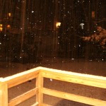
An impressive band of moisture has set up over Metro Richmond these evening. An upper level low coming out the great lakes has made spun some moisture over the mountains and we have has some impressive snowfall this evening. Already a dusting of snow is on most surfaces and the snow appears to be sticking around for the next few hours. Maybe 1/2″ to 1″ might be possible?
What a roller coaster ride this storm event has been! Only 24 hours ago, most of the local meteorologists were calling for a dusting to an inch of snowfall today. The weather models were consistently pushing the system out to sea with little impact on the commonwealth. Late last night, the models took a dramatic shift by pulling the storm back to the coast, supporting the position of the Euro model only two days ago. This looks like a potentially record setting snow storm for the east coast. As of 10:30 AM, the NWS forecast for Richmond is:
Christmas Day: A chance of snow. Cloudy, with a high near 37. Calm wind. Chance of precipitation is 40%. Little or no snow accumulation expected.
Tonight: Snow likely. Cloudy, with a low around 27. Calm wind becoming north around 5 mph. Chance of precipitation is 70%. New snow accumulation of 1 to 3 inches possible.
Sunday: Snow. High near 32. North wind between 8 and 15 mph. Chance of precipitation is 90%. New snow accumulation of 1 to 3 inches possible.
Sunday Night: A chance of snow, mainly before midnight. Cloudy, with a low around 23. North wind around 17 mph. Chance of precipitation is 50%.
That’s about 2-6″. Other professional meteorologists have us pegged for 6-12″. There has even been mention of 9-15″ in Metro Richmond. Observations will begin this afternoon with photos and videos going up this evening and into tomorrow.
The latest computer guidance and models seem to be coming into agreement for a sizable storm for central and southeastern Virginia this weekend. The NWS forecast for the weekend storm is (Richmond Metro):
Friday Night: A chance of snow. Mostly cloudy, with a low around 28. Chance of precipitation is 30%.
Christmas Day: A chance of snow. Cloudy, with a high near 36. Chance of precipitation is 40%.
Saturday Night: A chance of snow. Cloudy, with a low around 27. Chance of precipitation is 50%.
Sunday: A chance of snow. Mostly cloudy, with a high near 35. Chance of precipitation is 30%.
The latest 12z GFS is sowing the formation of a costal storm during the day on Saturday:
Stay tuned for further updates.
Update: 12/24/2010
The models have come into general agreement that this storm will take a more easterly path and not create a massive snow storm for central Virginia. Instead, a smaller upper level disturbance from the Midwest will likely swing through tomorrow afternoon (12/25) and tomorrow night to produce some snow showers. Local meteorologists are estimating anywhere from a dusting to an inch. The track of this storm is still uncertain, so it will still bear some watching today and tomorrow. Observation posts will be posted tomorrow if snow looks likely.
URGENT - WINTER WEATHER MESSAGE
NATIONAL WEATHER SERVICE WAKEFIELD VA
311 PM EST WED DEC 15 2010
...SNOW...POSSIBLY MIXED WITH SLEET AND LIGHT FREEZING RAIN LATE
TONIGHT AND THURSDAY...
THE NATIONAL WEATHER SERVICE IN WAKEFIELD HAS ISSUED A WINTER
STORM WARNING FOR HEAVY SNOW...WHICH IS IN EFFECT FROM 4 AM TO 7 PM
EST THURSDAY. THE WINTER STORM WATCH IS NO LONGER IN EFFECT.
* ACCUMULATION...2 TO 5 INCHES OF SNOW.
* ICE AMOUNTS...A TRACE TO ONE TENTH OF AN INCH OF ICE IS
POSSIBLE...MAINLY TOWARD THE NORTH CAROLINA BORDER THURSDAY
AFTERNOON AND EVENING.
* TIMING: LATE TONIGHT THROUGH THURSDAY EVENING.
* IMPACTS: HAZARDOUS TRAVEL CONDITIONS.
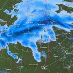
12/15 9:00PM: Not much has changed in the past few hours in terms of the forecast. Some areas to the west had the snow totals increased to 3-7″
The main precip shield is still just west of the Apps, and, amazingly, it stretches NW up to Bismark!
12/15 21:00Z
Current & Historical Weather Events in Richmond, Virginia
 Our last chance for snow from this dynamic storm system is getting closer to reaching metro Richmond this afternoon and evening. Will we see heavy wet snow as forecasted by NWS? The radar looks promising as we recieve some thunderstorms first, followed by snow this evening!