Deprecated: Optional parameter $selected declared before required parameter $args is implicitly treated as a required parameter in /home/richmon/domains/richmondcitywatch.com/public_html/rvawx_test/wp-content/plugins/archives-calendar-widget/arw-settings.php on line 178
Deprecated: Optional parameter $view declared before required parameter $args is implicitly treated as a required parameter in /home/richmon/domains/richmondcitywatch.com/public_html/rvawx_test/wp-content/plugins/archives-calendar-widget/arw-widget.php on line 480
Deprecated: Optional parameter $archiveMonth declared before required parameter $args is implicitly treated as a required parameter in /home/richmon/domains/richmondcitywatch.com/public_html/rvawx_test/wp-content/plugins/archives-calendar-widget/arw-widget.php on line 480
Warning: Trying to access array offset on value of type bool in /home/richmon/domains/richmondcitywatch.com/public_html/rvawx_test/wp-content/plugins/archives-calendar-widget/archives-calendar.php on line 64 December | 2012 | RVAWX.com
No signs of winter appeared with this storm system for metro Richmond. Rain began early in the morning and tapered off by 11 AM. About 0.15″ of rain fell during the event with tempratures hovering between 37-39 degrees. Snow fell to the north and west of Richmond, mainly from Charlottesville and DC north.
Signs point to another possible storm system aimed at the area between January 2nd -4th. I’ll post a forecast thread tomorrow to discuss the possibilities.
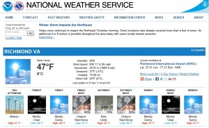
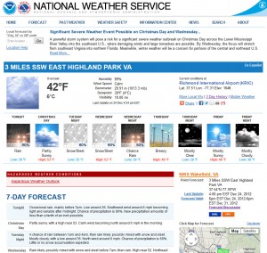
A rather complex storm system may impact the area on Saturday (December 29, 2012) that could bring a mixed bag of precipitation, mostly in the form of rain. However, there is a chance of snow for the area, as noted in the current NWS forecast:
NWS Forecast for 12/29/12
If this event pans out, this would be our first observation of snow for the season. It could also be our first chance for accumulating snow as well. More discussion about this event is detailed below in the NWS extended discussion:
.SHORT TERM /6 PM THIS EVENING THROUGH SATURDAY NIGHT/…
WINDS WILL SLOWLY SUBSIDE THIS EVENING AS PRESGRADIENT
SLACKENS…ALTHOUGH WILL STAY BREEZY ON THE ERN SHORE THROUGH THE
EVENING. OTHERWISE…HIGH PRESSURE SLIDES OFF THE COAST BY LATER
FRI AND THE REGION WILL RESIDE UNDER A MOSTLY CLEAR SKY ONCE AGAIN
THU NIGHT AND FRIDAY. EARLY MORNING LOW TEMPS SHOULD BE COLDER FRI
MORNING WITH READINGS IN THE MID 20S TO MID 30S AND HIGHS NEAR NORMAL IN THE UPPER 40S TO AROUND 50 FRI.
THE NEXT LOW PRESSURE SYSTEM SLATED TO AFFECT THE MID ATLANTIC
STATES WILL BEGIN TO DEVELOP IN THE GULF COAST STATES FRI NIGHT
AND TRACK NE TWD THE REGION OVERNIGHT INTO EARLY SAT MORNING. MID- UPPER LEVELFLOW IS FAIRLY PROGRESSIVE INITIALLY SO THE SFC LOW
DOES NOT INTENSIFY THAT MUCH FRI NIGHT INTO SAT MORNING.
HOWEVER…OVERRUNNING PRECIP IS EXPECTED TO SPREAD ACROSS THE
REGION FROM SW TO NE EARLY SAT MORNING. WHILE THERE IS THE LACK OF A
COLD AIR WEDGE…TEMPS SHOULD HAVE NO PROBLEM FALLING NEAR
FREEZING BEFORE CLOUDS MOVE IN AND PREVENT THE ATMOSPHERE FROM
COOLING FURTHER. WITH THIS IN MIND…PRECIP MAY START AS ALL SNOW
IN FAR NW ZONES WITH A RAIN/SNOW TRANSITION ZONE TO ALL RAIN OVER
SE AREAS. IT DOES LOOK RATHER LIGHT INITIALLY SO ACCUMULATIONS
WOULD BE LIGHT. PRECIP IS EXPECTED TO BECOME ALL RAIN BY LATE
MORNING AS TEMPS WARM WELL ABOVE FREEZING…BUT HAVE GONE BELOW
GUIDANCE FOR HIGHS…MAINLY 40-45…UPR 40S TO LWR 50S FAR SE
VA/NE NC.
THE CHALLENGING PART OF THE FCST COMES SAT NIGHT…HOW FAST DOES
COLDER AIR COME IN FROM THE NW AND HOW RAPIDLY DOES THE SFC LOW
INTENSIFY? NOTE THAT LATEST 00Z ECMWF SHOWS RAPID INTENSIFICATION
OF THE SFC LOW AND KEEPS IT CLOSER TO THE COAST DUE TO MORE
AMPLIFICATION OF THE UPPER TROUGH. THIS TRACK WOULD POTENTIALLY
LEAD TO SOME ACCUMULATING SNOW IN MAINLY NE PORTIONS OF THE CWA. GFS
IS WEAKER/SLOWER TO BRING IN COLD AIR…AND THE SFC LOW TRACKS
FARTHER OFF THE COAST W/ LITTLE MORE THAN A SMALL CHC FOR LIGHT
SNOW SHOWERS SAT EVENING/EARLY SUNDAY ACRS MAINLY THE ERN SHORE.
THE LATEST GFSENSEMBLE SHOWS A LARGE SPREAD ON THE WEST SIDE OF
THE GFS TRACK SO THE ECMWF MAY BE ON TO SOMETHING…SO FCST WILL
TAKE THIS INTO ACCOUNT AND SIDE CLOSER TO THE COLDER SCENARIO.
GRIDDED FCST HAS CHANGEOVER BY 00Z NW…TO THE COAST BY
MIDNIGHT…WHICH IS FAIRLY CLOSE TO THE 1295 M 1000-850 THICKNESS
VALUES FROM THE ECMWF.
The major winter storm (termed “Euclid” from TWC) that churned through yesterday brought a round of heavy rain to central Virginia. No snow or sleet was reported at the airport. In addition, I did not see any sleet or snow during the beginning at the event. My location in Church Hill received 1.24″ of rain yesterday. As of today, we still do not have any snow observations for the season in Richmond.
The January 30th, 2010 snowstorm will mark the fourth winter storm to be profiled in a series of articles to be posted on our blog. We hope you find these weather event musings entertaining and factual. These articles will portray some of the most memorable snow events that Russ and I have lived through while residing in Richmond, Virginia.
Before the Storm: The winter of 2009-2010 was already off to significant start with the December 18/19th snowstorm. Considering ourselves lucky with the storm in December, there was an element of disbelief that another large storm was set to hit the area in late January. By Thursday, January 28th, the NWS had issued a winter storm watch for Metro Richmond warning of a snow event that could drop 5 to 10 inches of snow. As Saturday approached, signs of the storms power and potency became apparent.
Synoptic Overview of Storm System: A low pressure system developed over the Gulf Coast spawned a widespread snow event from Tennessee to the Delmarva peninsula. The first reference link below provides a much more detailed and analytical write-up of the system’s dynamics.
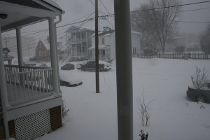
Heavy snowfall and low visibility from the house.
The Main Event: This event started just before sunrise on Saturday morning, lasting until late in the evening in Metro Richmond. One of the most notable things about this storm is how cold the event turned out to be. From the onset, tempreatures were in the low 20’s and never got above 29 degrees the entire day. There were no mixing issues in this storm, everything that fell was pure snow. Since it was the weekend, I didn’t have to work so I enjoyed the snowfall all day long. Russ and I ventured down to Libby Hill Park around 11 AM to do some sledding. Around 5-6″ of snow had fallen by then. This time period also had the peak snowfall rates for this storm. Visibility was incredibly low and the wind was constantly gusting in the 10-15 MPH range out of the north. The walk home from the park that afternoon was a painful one since the snow was driving in on a north wind, we were walking northbound.
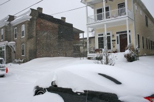
Small drifts of snow along North 29th Street.
The snowfall rate easily approached 1-1.5″ an hour at times that morning. There were points in the morning that near whiteout conditions occurred. It was some of the most incredible heavy day snowfall I’ve ever seen. Overall, snowfall rates coupled with the wind made it feel miserable outside.
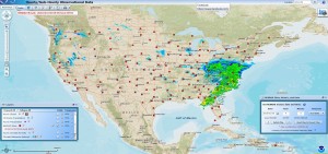
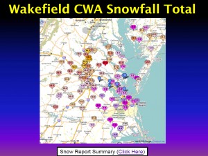
Wakefield CWA Snowfall Totals
Snow quickly tapered off the night after the storm. When all was said and done, we had a remarkable 12.25″ of snow in Church Hill! Since owning a home here (Nov. 2007), this is the largest single snow event I’ve witnessed at this location.
Snowfall RSI Map for Event
My official measurement did not coincide with the official measurement at the airport. Snow measurements were taken in several open spots around the block.
The day after Christmas, a complex and potentially potent storm system will develop over the southern United States and track to the northeast. The low will redevelop near Richmond and then track northeastward towards across the Delmarva peninsula. The forecast for this system seemed more promising about 8-10 days out with a higher chance of rain and snow for the Richmond metro area. Today, the weather models have shifted and focused the brunt of the winter weather to interior portions of the Ohio Valley, Mid-Atlantic and Northeast corridor (interior regions).
It’s worth mentioning this storm now since their is a small chance of Richmond’s having its first snowfall/sleet/freezing rain event of the season. The NWS has made mention of the snow/sleet potential for this storm system early Wednesday Morning.
NWS Forecast for 23223
As of today, we have not seen any wintry weather in Richmond. Here is to hoping that we can catch a few flakes or pellets from this system before it turns to rain (which could be as much as .75 – 1.5″ of rain).
Current & Historical Weather Events in Richmond, Virginia