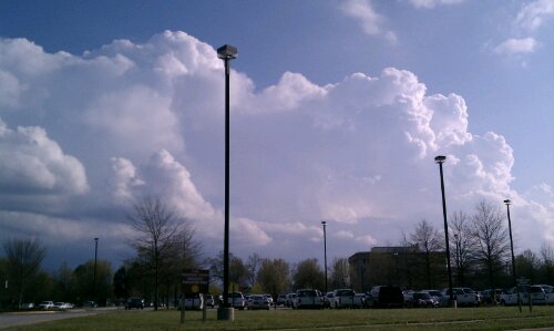
Storm threat looms for the evening hours over the mid-atlantic:

Storm threat looms for the evening hours over the mid-atlantic:

MESOSCALE DISCUSSION 1004
NWS STORM PREDICTION CENTER NORMAN OK
1203 PM CDT FRI JUN 01 2012
AREAS AFFECTED…NC…VA…WV…MD…DC…PA
CONCERNING…SEVERE POTENTIAL…TORNADO WATCH LIKELY
VALID 011703Z – 011830Z
PROBABILITY OF WATCH ISSUANCE…80 PERCENT
SUMMARY…THUNDERSTORMS WILL INCREASE THROUGH THE AFTERNOON IN A
VERY MOIST AND INCREASINGLY UNSTABLE AIRMASS FROM NC NWD ACROSS
VA…SRN PA…WV PNHDL…AND MD/DC AREA. RECENT TRENDS SUGGEST THAT
ISOLATED STORMS WILL FIRST POSE A THREAT FOR ISOLATED SEVERE WEATHER
IN THE FORM OF HAIL/WIND OVER PARTS OF NERN NC AND SERN VA WHERE
INSTABILITY IS GREATEST BUT SHEAR AND FORCING WILL REMAIN LIMITED
FOR A TIME. ADDITIONAL SEVERE STORMS ARE LIKELY AS A FORCED SQUALL
LINE DEVELOPS EAST OF THE APPALACHIANS LATER THIS AFTERNOON. DEEP
SHEAR AND TORNADO POTENTIAL MAY INCREASE ACROSS THE ENTIRE REGION
FROM LATE AFTERNOON INTO EVENING AND ONE OR MORE TORNADO WATCHES
WILL LIKELY BE ISSUED OVER THE NEXT 1-2 HOURS.
DISCUSSION…STRONG FORCED ASCENT WITH A LARGE SCALE TROUGH WAS
LIKELY RESULTING IN AN INCREASE IN LOW-TOPPED CONVECTION ALONG A
COLD FRONT NOW SITUATED FROM ERN OH SWD ACROSS WV…EXTREME SWRN VA
AND ERN TN. EXPECT THAT THIS CONVECTION WILL CROSS THE SPINE OF THE
APPALACHIANS OVER THE NEXT 2 HOURS. AS THIS FORCING BEGINS TO
INTERACT WITH GREATER INSTABILITY EAST OF THE MOUNTAINS…MORE
VIGOROUS STORM DEVELOPMENT IN THE FORM OF BOWING/LEWPING SEGMENTS
CAN BE EXPECTED. A WEAK FRONTAL WAVE MAY ALSO TAKE FORM WITH TIME
COINCIDENT WITH AN INCREASE IN STORMS ALONG A WARM FRONT EXTENDING
ACROSS SRN PA AND INTO THE DELMARVA REGION. IN ADDITION TO WIND
DAMAGE THREAT WITH STORMS ALONG THE ADVANCING FRONT…AN ENHANCED
BUT FOCUSED TORNADO THREAT MAY EVOLVE NEAR THE FRONTAL WAVE AND WARM
FRONT. ONE TORNADO WATCH WILL LIKELY BE NEEDED FROM SRN PA ACROSS
WRN VA WITHIN THE NEXT HOUR OR SO.
ANOTHER WATCH WILL LIKELY BE NEEDED FROM THE ONGOING STORMS OVER NRN
NC NWD ACROSS THE VA TIDEWATER AREA. STORMS IN THIS AREA ARE
DEVELOPING WITH HEATING OF THE DAY AND PERHAPS THE LARGER SCALE
ASCENT DEVELOPING EAST WITH THE TROUGH. WHILE INSTABILITY IS GREATER
IN THIS CORRIDOR…DEEP SHEAR AND FORCING ARE LIKELY MORE MARGINAL
TO SUPPORT A MORE WIDESPREAD IMMEDIATE THREAT OF SEVERE TSTMS
WIND/TORNADOES. NONETHELESS…SHEAR WILL LIKELY INCREASE
SUFFICIENTLY WITH TIME ACROSS THIS AREA TO WARRANT A TORNADO WATCH
AND THIS WATCH WILL LIKELY BE COORDINATED SHORTLY.
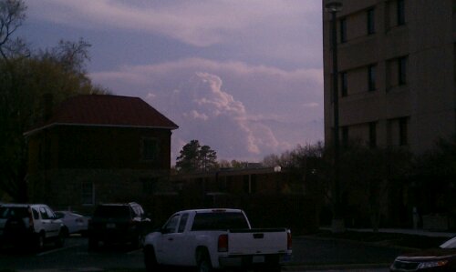
Looking south from the Chesterfield Courthouse.
A period of light to moderate snow rolled through Central Virginia this morning giving most of the area a light dusting of snow. Areas located north of Midlothian typically saw 1/2″ to as much as 2″ of snow. Areas further north and east of town (Caroline & King William Counties) had reports of 4-6″ of snow. The main batch of snow tapered off around 8:30 AM and mixed with rain and snow showers for the rest of the day. After the initial burst of snow this morning, most of the accumulating snow melted by noon. Not an unusual event given that it is now March.

My Report (Church Hill):
* Place – Time: Church Hill, 10:44 AM (3/5/2012) *After the Event Update*
* Temperature: 33-34, During Storm Event
* Dewpoint: 30-32, During Storm Event
* Relative Humidity: 95%
* Pressure: N/A
* Trends: N/A
*Winter Weather Watch/Warning/Advisory: Advisory
* Road Conditions: Roads were all passable, no accumulation on primary or secondary roads.
* Precipitation Description: Light, moderate snow fell throughout the event. As snow tapered off, snow changed to drizzle and temperature rose considerably.
* Total Precip: 1.0″ of snow on elevated/grassy surfaces. Liquid Equivalent of 0.1″ fell during the event in Church Hill.
* Comments: Event was spurred by a Canadian clipper that dove down the Illinois and Kentucky and moved through Central Virginia. Precipitation started at 6:30 AM as light snow. The precipitation fell as light to occasionally moderate snow until about 8:30 AM. Snow covered all elevated surfaces. Dry slot as well as warmer air moved in by 9:00 AM. School systems closed in Chesterfield, Henrico & Richmond. No trace of snow at Chesterfield Courthouse by 11 AM. Rain and snow showers continued in the area until 6 PM.
Link to Gallery Images: http://www.612.richmondcitywatch.com/modules/gallery2/main.php?g2_itemId=2826
It looks like a potent clipper system diving through the upper midwest will be arriving in Central Virginia by 5 AM.The forecast is for around 1-3″ of snow. It’ll be interesting to see how much accumulation we get on Monday morning!


URGENT - WINTER WEATHER MESSAGE
NATIONAL WEATHER SERVICE WAKEFIELD VA
1029 PM EST SUN MAR 4 2012

NCZ012-VAZ060-061-065>071-079>081-087-088-092-051130-
/O.CON.KAKQ.WW.Y.0004.120305T0900Z-120305T1700Z/
NORTHAMPTON NC-PRINCE EDWARD-CUMBERLAND-MECKLENBURG-LUNENBURG-
NOTTOWAY-AMELIA-POWHATAN-CHESTERFIELD-HENRICO-BRUNSWICK-DINWIDDIE-
PRINCE GEORGE-GREENSVILLE-SUSSEX-SOUTHAMPTON-
INCLUDING THE CITIES OF...MARGARETTSVILLE...FARMVILLE...
SOUTH HILL...CREWE...COLONIAL HEIGHTS...RICHMOND...
LAWRENCEVILLE...PETERSBURG...HOPEWELL...EMPORIA...WAKEFIELD...
FRANKLIN
1029 PM EST SUN MAR 4 2012

...WINTER WEATHER ADVISORY REMAINS IN EFFECT FROM 4 AM TO NOON
EST MONDAY...

A WINTER WEATHER ADVISORY REMAINS IN EFFECT FROM 4 AM TO NOON EST
MONDAY.

* AREAS AFFECTED: THE EAST CENTRAL VIRGINIA PIEDMONT THROUGH
  SOUTH CENTRAL VIRGINIA AND NORTHAMPTON COUNTY NORTH CAROLINA.

* HAZARDS: SNOW

* ACCUMULATIONS: PRIMARILY 1 TO 2 INCHES...WITH ISOLATED AMOUNTS
  UP TO 3 INCHES IN THE SOUTH CENTRAL VIRGINIA PIEDMONT.

* TIMING: EARLY MONDAY MORNING...INCLUDING RUSH HOUR AND THROUGH
  MIDDAY.

* IMPACTS: SNOW SHOULD MAINLY ACCUMULATE ON NON-PAVED AND ELEVATED
  SURFACES SUCH AS BRIDGES AND OVERPASSES.

PRECAUTIONARY/PREPAREDNESS ACTIONS...

A WINTER WEATHER ADVISORY FOR SNOW MEANS THAT PERIODS OF SNOW
WILL CAUSE PRIMARILY TRAVEL DIFFICULTIES. BE PREPARED FOR SNOW
COVERED ROADS AND LIMITED VISIBILITY...AND USE CAUTION WHILE
DRIVING.
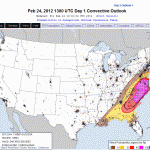
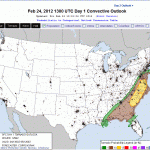
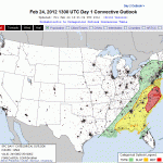
The severe weather outlook looks quite ominious for this afternoon:

Days With High Temps Above Avg: 17
Days With Low Temps Above Avg: 11
Highest Temp: 72.1 on 2/23
Lowest Temp: 14.7 on 2/13
Mean Temp thru the 23rd: 42.8
Snow: 3.9″ on 2/18 (RIC only had a trace before this)
After last weekend’s weak Winter storm that dumped 3-6″ across RVA, will we see any more? Chances are slim to none. With temps reaching 70+ today, the snow is a distant memory. We could also see some thunderstorms tomorrow evening. NAM CAPE values of 500+ could, along with strong upper shear, create some decent severe weather from Richmond and south.
A cold front will move in Saturday with highs in the 50’s. Then its back to the 60’s again.
The current GFS shows a nice rain event on March 1st, and a bigger one on the 4th and 5th. So…Winter 11-12′, goodbye. Stay tuned for an in depth look at this Winter and its impacts on the RVA. We’ll soon be transitioning to severe weather discussion.


