Deprecated: Optional parameter $selected declared before required parameter $args is implicitly treated as a required parameter in /home/richmon/domains/richmondcitywatch.com/public_html/rvawx_test/wp-content/plugins/archives-calendar-widget/arw-settings.php on line 178
Deprecated: Optional parameter $view declared before required parameter $args is implicitly treated as a required parameter in /home/richmon/domains/richmondcitywatch.com/public_html/rvawx_test/wp-content/plugins/archives-calendar-widget/arw-widget.php on line 480
Deprecated: Optional parameter $archiveMonth declared before required parameter $args is implicitly treated as a required parameter in /home/richmon/domains/richmondcitywatch.com/public_html/rvawx_test/wp-content/plugins/archives-calendar-widget/arw-widget.php on line 480
Warning: Trying to access array offset on value of type bool in /home/richmon/domains/richmondcitywatch.com/public_html/rvawx_test/wp-content/plugins/archives-calendar-widget/archives-calendar.php on line 64 November | 2013 | RVAWX.com
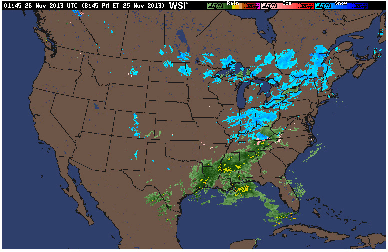
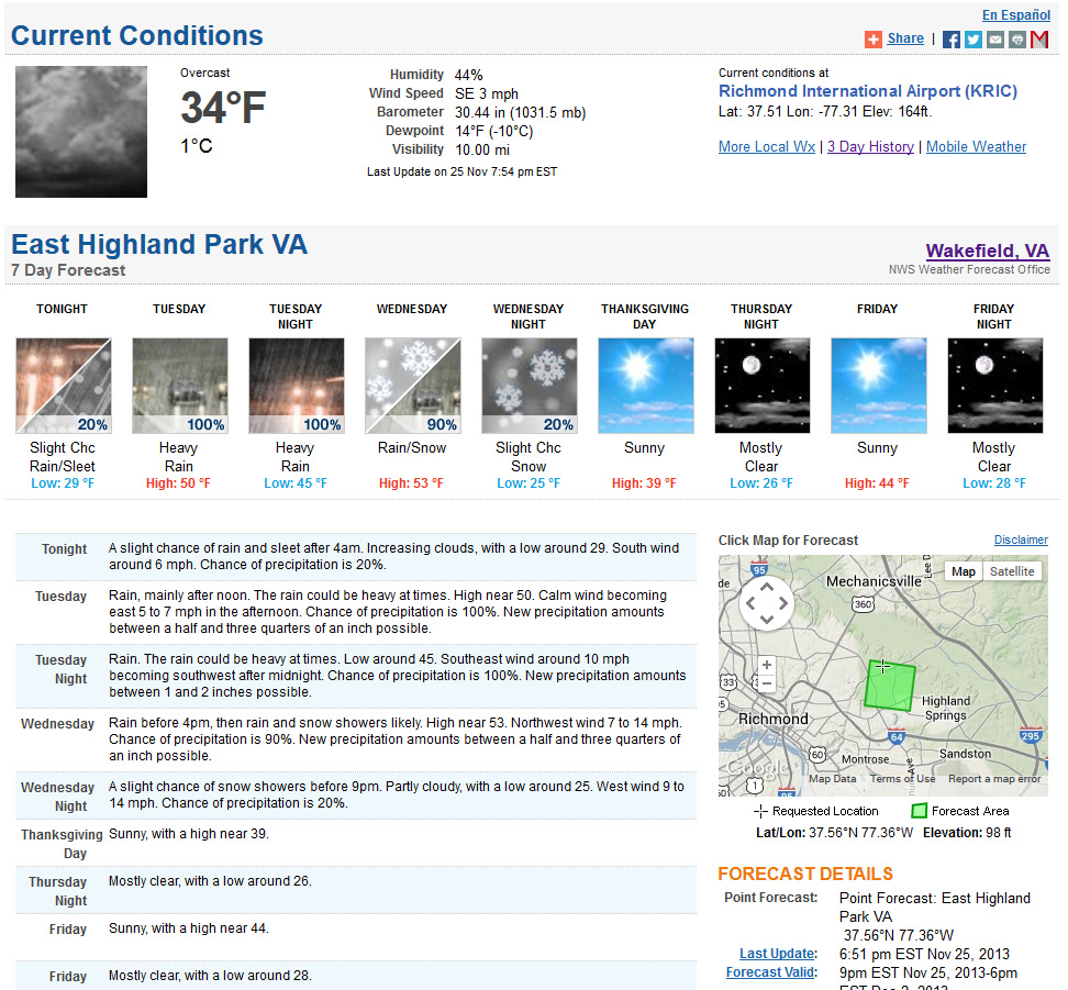
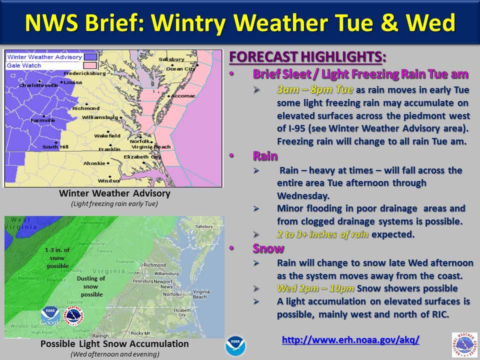
A chance for some sleet is possible on Tuesday morning followed by some back end snow on Wednesday afternoon. Upwards of 2-3″ of rain is forecast for the Richmond area on Tuesday and Wednesday. If snow occurs on Wednesday, accumulations are expected to be light.
NWS Forecast from 11/25/2013
HWO from Wakefield:
HAZARDOUS WEATHER OUTLOOK
NATIONAL WEATHER SERVICE WAKEFIELD VA
352 PM EST MON NOV 25 2013
VAZ063-064-070-071-079-080-262100-
HANOVER-CAROLINE-CHESTERFIELD-HENRICO-BRUNSWICK-DINWIDDIE-
352 PM EST MON NOV 25 2013
THIS HAZARDOUS WEATHER OUTLOOK IS FOR CENTRAL VIRGINIA AND SOUTH
CENTRAL VIRGINIA.
.DAY ONE…THIS AFTERNOON AND TONIGHT.
HAZARDOUS WEATHER IS NOT EXPECTED AT THIS TIME.
.DAYS TWO THROUGH SEVEN…TUESDAY THROUGH SUNDAY.
A LOW PRESSURE SYSTEM WILL DEVELOP IN THE GULF OF MEXICO ON
TONIGHT AND EARLY TUESDAY…AND WILL TRACK NORTHEAST TOWARDS THE
OUTLOOK AREA LATE TUESDAY INTO WEDNESDAY. RAIN IS EXPECTED TO
DEVELOP BY MIDDAY TUESDAY AND CONTINUE THROUGH WEDNESDAY. THERE IS
THE POTENTIAL FOR A BRIEF PERIOD OF LIGHT FROZEN PRECIPITATION
COINCIDING WITH THE TUESDAY MORNING RUSH HOUR…BEFORE A QUICK
CHANGE BY ALL RAIN BY MID-MORNING TUESDAY. NO ACCUMULATION IS
EXPECTED.
* Place – Time: Chesterfield Government Complex, 3:00 PM (11/12/2013)
* Temperature: 40-41, During Event
* Dewpoint: 29-30, During Event
* Relative Humidity: N/A%
* Pressure: N/A
* Trends: N/A
*Winter Weather Watch/Warning/Advisory: N/A
* Road Conditions: All roads remained passable, no accumulation.
* Precipitation Description: Light rain and snow showers persisted on and off during the afternoon hours.
* Total Precipitation: Trace of snow. Liquid equivalent of 0.0” fell during the event.
* Comments: A rain/snow mix started shortly after 1:15 PM. The snow persisted for about 20 minutes. Precipitation ended around 2 PM. No accumulation of snow was observed due to high air and ground temperatures. This was the first snow event of the 2013-2014 winter season.
Hurricane Sandy blew to the east and north of Richmond before becoming a hybrid storm slamming into the New Jersey Coast on October.
My observations of the storm were pretty tame. In Church Hill, we encountered mostly light to moderate rain with sustained winds around 5-15 MPH. Wind gusts approaching 25-35 MPH were infrequent. Recorded rainfall at my house was 2.25″.
NWS Path & Estimated TS Winds
Below is a collection of photos I saved from the event.
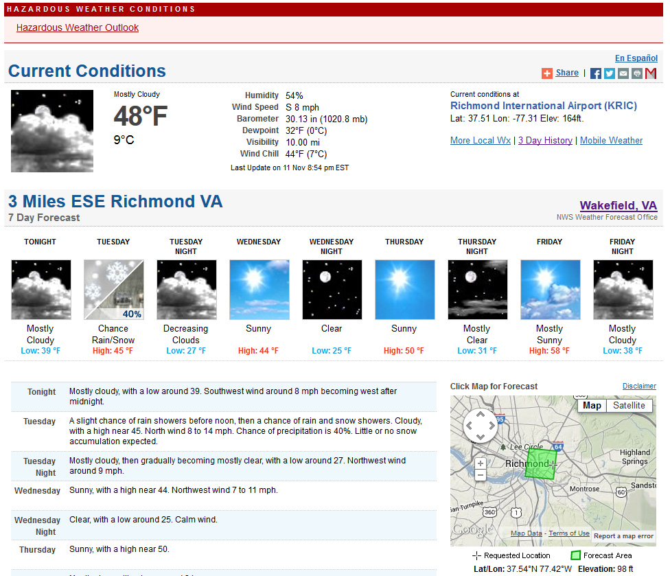
An arctic front will cross the region tomorrow bringing much cooler temperatures into Central Virginia. One feature of the system could be the season’s first appearance of snow. No accumulation is expected per the NWS forecast.
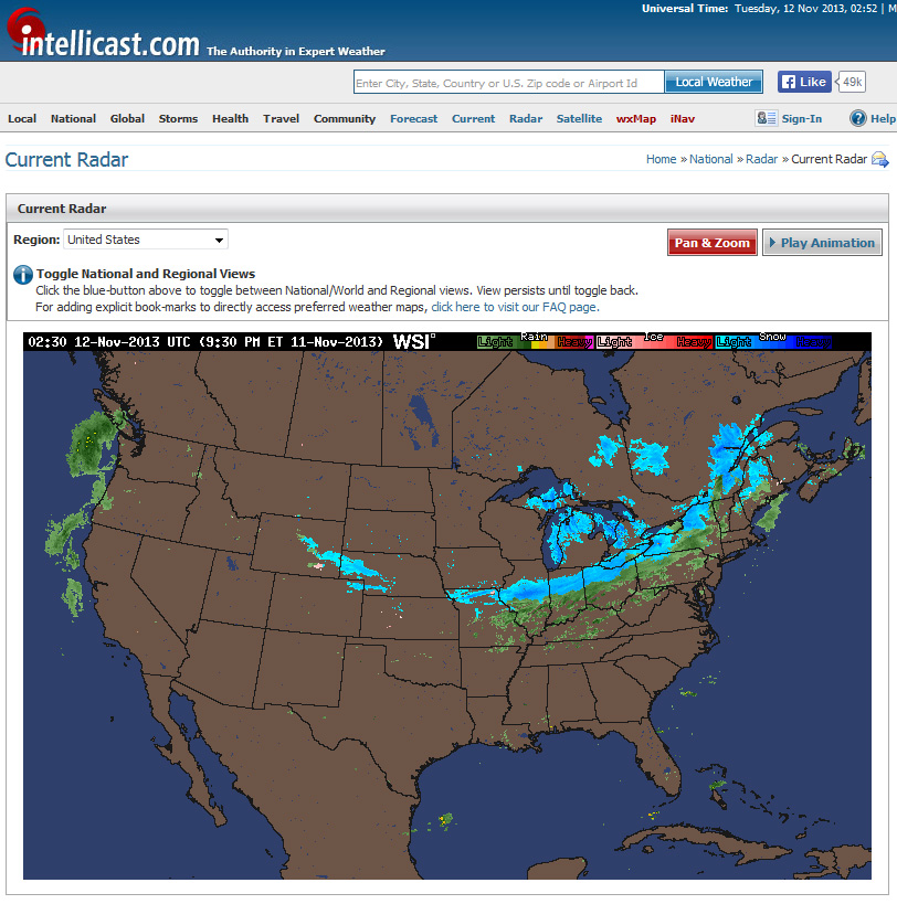
NWS Forecast11/11/13 Radar
THIS HAZARDOUS WEATHER OUTLOOK IS FOR THE LOWER EASTERN SHORE OF
MARYLAND...COASTAL NORTHEAST NORTH CAROLINA...INTERIOR NORTHEAST
NORTH CAROLINA...CENTRAL VIRGINIA...EAST CENTRAL
VIRGINIA...INTERIOR SOUTHEAST VIRGINIA...SOUTH CENTRAL
VIRGINIA...SOUTH HAMPTON ROADS VIRGINIA...THE EASTERN SHORE OF
VIRGINIA...THE MIDDLE PENINSULA OF VIRGINIA...THE NORTHERN NECK OF
VIRGINIA...THE PENINSULA OF SOUTHEAST VIRGINIA AND THE PIEDMONT OF
CENTRAL VIRGINIA.

.DAY ONE...TONIGHT.

HAZARDOUS WEATHER IS NOT EXPECTED AT THIS TIME.

.DAYS TWO THROUGH SEVEN...TUESDAY THROUGH SUNDAY.

A STRONG COLD FRONT WILL DROP ACROSS THE AREA TUESDAY...BRINGING
THE COLDEST AIR OF THE SEASON TO DATE TO THE MID-ATLANTIC REGION.
RAIN SHOWERS MAY MIX WITH A FEW WET SNOWFLAKES BEHIND THE FRONT
ON TUESDAY THROUGH TUESDAY EVENING...THOUGH NO IMPACTS TO TRAVEL
ARE EXPECTED. ALSO...WIND GUSTS TO 30 MPH WILL BE POSSIBLE TUESDAY
AND TUESDAY NIGHT.

.SPOTTER INFORMATION STATEMENT...
The first freezing temperature for the fall of 2013 occurred on November 9 (31.9 in Church Hill). The first freeze for the airport occurred on October 26 with a low of 32.
Current & Historical Weather Events in Richmond, Virginia