Category Archives: Winter Weather

January 26, 2015: Snow from a Manitoba Mauler?

A potent upper level system originating from Manitoba may bring the first accumulating snowfall to Metro Richmond on Monday into Monday night. The NWS service seems to think that there could be some accumulating snow.

NWS Forecast on 1/24/15


NWS Forecast from 1/25/15

520 AM EST SAT JAN 24 2015

THIS HAZARDOUS WEATHER OUTLOOK IS FOR THE LOWER EASTERN SHORE OF
MARYLAND…CENTRAL VIRGINIA…EAST CENTRAL VIRGINIA…SOUTH CENTRAL
VIRGINIA…THE EASTERN SHORE OF VIRGINIA…THE MIDDLE PENINSULA OF
VIRGINIA…THE NORTHERN NECK OF VIRGINIA…THE PENINSULA OF
SOUTHEAST VIRGINIA AND THE PIEDMONT OF CENTRAL VIRGINIA.

.DAY ONE…TODAY AND TONIGHT.

HAZARDOUS WEATHER IS NOT EXPECTED AT THIS TIME.

.DAYS TWO THROUGH SEVEN…SUNDAY THROUGH FRIDAY.

A COLDER STORM SYSTEM WILL BRING THE POTENTIAL FOR ACCUMULATING
SNOW MONDAY AFTERNOON THROUGH MONDAY NIGHT.

.SPOTTER INFORMATION STATEMENT…

SPOTTER ACTIVATION IS NOT EXPECTED AT THIS TIME.


(1/25/15): NWS HWO - RAIN WILL MIX WITH AND EVENTUALLY CHANGE TO SNOW ACROSS THE
OUTLOOK AREA MONDAY EVENING...AS AN AREA OF LOW PRESSURE
INTENSIFIES OFF THE NORTHERN MID-ATLANTIC COAST. A LIGHT
ACCUMULATION OF SNOW IS POSSIBLE LATE MONDAY NIGHT INTO TUESDAY
MORNING.
NWS Snow Forecast
NWS Snow Forecast


NWS Snow Forecast, 1/25/15

January 14, 2015: Observations

Church Hill Storm Observation Summary:
* Place – Time: Church Hill, (1/14/2015)
* Temperature: 27-28, During Event
* Winter Weather Watch/Warning/Advisory: Advisory, which was issued towards end of the event
* Closings: All local school districts closed, Chesterfield County Government had a delayed opening for 10:30 AM. Government closed for the day at 10:00 AM.
* Predicted Totals: Very light accumulation of freezing rain and sleet.
* Road Conditions: All roads had varying amounts of ice and sleet that accumulated on them. Local streets were very poor most of the day.
* Precipitation Description: A mix of freezing drizzle, freezing rain and brief periods of sleet from 12 AM to 6 AM.
* Total Precipitation: Approximately 0.14″ of sleet and ice accumulation. Sleet and freezing rain accumulated on all surfaces. 0.21″ of liquid equivalent was reported at the Richmond airport. It took an extensive amount of time to melt the ice from my car.
* Comments: A low developed off the Florida coast and quickly bypassed the area off the Carolina coast. A fresh wave of cold air provided more than adequate temperatures to support sleet and freezing rain at the surface. Periods of sleet and freezing rain occurred during the early morning hours, before tapering off by sunrise. Impacts from snow and ice to the Richmond area were moderate from this storm.

Snowfall Totals:

Mixed Precipitation Totals

Photos:

March 25, 2014: Snow to Rain, then Snow?

NWS Forecast for 3/25

An impressive low-pressure system will develop off the Georgia coast tomorrow morning and race northeastward towards New England. The track of this storm will situate the brunt of its precipitation offshore. However, a period of light snow tomorrow morning and tomorrow evening may give Central Virginia a light dusting of snow.

Forecasted snowfall.


Hazardous Weather Outlook

HAZARDOUS WEATHER OUTLOOK

NATIONAL WEATHER SERVICE WAKEFIELD VA

628 AM EDT MON MAR 24 2014


VAZ060-064>086-251030-

PRINCE EDWARD-CAROLINE-MECKLENBURG-LUNENBURG-NOTTOWAY-AMELIA-

POWHATAN-CHESTERFIELD-HENRICO-KING WILLIAM-KING AND QUEEN-ESSEX-

WESTMORELAND-RICHMOND-NORTHUMBERLAND-LANCASTER-BRUNSWICK-DINWIDDIE-

PRINCE GEORGE-CHARLES CITY-NEW KENT-GLOUCESTER-MIDDLESEX-MATHEWS-

628 AM EDT MON MAR 24 2014


THIS HAZARDOUS WEATHER OUTLOOK IS FOR CENTRAL VIRGINIA…EAST

CENTRAL VIRGINIA…SOUTH CENTRAL VIRGINIA…THE MIDDLE PENINSULA OF

VIRGINIA…THE NORTHERN NECK OF VIRGINIA AND THE PIEDMONT OF

CENTRAL VIRGINIA.


.DAY ONE…TODAY AND TONIGHT.


COLD CANADIAN HIGH PRESSURE WILL RESULT IN WELL BELOW NORMAL

TEMPERATURES TODAY.


.DAYS TWO THROUGH SEVEN…TUESDAY THROUGH SUNDAY.


LOW PRESSURE WILL DEVELOP ALONG THE SOUTHEAST COAST TONIGHT AND

INTENSIFY RAPIDLY AS IT MOVES OFF THE MID-ATLANTIC COAST ON

TUESDAY. A PERIOD OF SNOW IS POSSIBLE ACROSS THE AREA TUESDAY

MORNING BEFORE TRANSITIONING TO A RAIN AND SNOW MIX TUESDAY

AFTERNOON. A BRIEF PERIOD OF SNOW IS ALSO POSSIBLE LATE TUESDAY AS

COLDER AIR SURGES INTO THE REGION. A LIGHT ACCUMULATION IS

POSSIBLE.


IN ADDITION…GUSTY NORTHWEST WINDS BETWEEN 20 TO 30 MPH WILL

DEVELOP TUESDAY NIGHT AND WEDNESDAY. WIND CHILLS WEDNESDAY MORNING

WILL DROP INTO THE MID TEENS.


.SPOTTER INFORMATION STATEMENT…


SPOTTER ACTIVATION IS NOT EXPECTED AT THIS TIME.

March 7, 2014: Observations

Freezing Rain on Windshield
Freezining Rain on Car

Church Hill Storm Observation Summary:
* Place – Time: Church Hill, (3/7/2014)
* Temperature: 32-33, During Event
* Winter Weather Watch/Warning/Advisory: Advisory
* Closings: None
* Road Conditions: All roads were wet during the event.
* Precipitation Description: Sleet, transitioned to freezing rain and then rain by 8 AM. Sleet began around 4:00 AM and quickly turned over to a mix of sleet and freezing rain by 7 AM.
* Total Precipitation: Less than 0.1″ of ice accumulation. Freezing rain accumulated on elevated surfaces.
* Comments: A low coming out of the Gulf of Mexico tracked up the east coast, delivering a severe snow and ice storm to western North Carolina and southwest Virginia. Impacts from ice to the Richmond area were minimal from this storm.

NWS Forecast, issued on 3/6/2014


February 12-13, 2014: Observations (Pax)

Event Updates:

As of 3:30 PM on 2/13, there is approximately 1.5″ of snow/sleet on the majority of surfaces in Church Hill. Temperature continues to slowly fall and is hovering at 34 degrees Fahrenheit. Rain has changed to sleet and now snow.

Radar from afternoon of 2/13/2014

Radar from evening of 2/12/2014

Church Hill Storm Observation Summary:
* Place – Time: Church Hill, (2/13/2014)
* Temperature: 25-37, During Event
* Winter Weather Watch/Warning/Advisory: Warning
* Closings: Chesterfield Government Closed on 2/13/14
* Road Conditions: All roads covered during event, primary roads cleared by the morning of 2/13. However, secondary roads were still partially snow covered.
* Precipitation Description: Snow, sleet, freezing rain and rain. Initial snow was very fine and powdery snowflakes. Event transitioned from snow to sleet near 11 PM on 2/12. Sleet changed to freezing rain by 1:00 AM on 2/13/14. Rain and Drizzle followed during the early morning hours until 2 PM on 2/13/14. Sleet and the sleet to snow transitioned back into Richmond by 3:30 PM.
* Total Precipitation: 5.75″ (4.25” of snow on 2/12, 1.5″ of snow on 2/13). Approximately 0.25″ of sleet. Minor accumulations of freezing rain. 3.7″ inches of snow was reported at the airport on 2/12, 2.1″ inches of snow was reported at the airport on 2/12 for a total of 5.8″. Snowfall totals were heavier towards the peidmont and mountains in western Virginia (6-21” was common).
* Comments: Snow began near 4 PM at the Chesterfield Courthouse on 2/12/14. Nearly .75″ had accumulated by 5:30 PM when I left work. My commute home took nearly an hour, which is about twice as long as it normally takes. Heavy snow occurred for about an hour between 9-10 PM when about an inch of snow fell. The precipitation quickly transitioned to sleet. Freezing rain then set in late in the evening after I went to bed. As the storm wrapped up on 2/13, drizzle changed to a brief round of heavy sleet and rain with two loud rumbles of thunder. An hour later, the second round of precipatation hit with moderate to heavy snowfall. The snow tapered off by 7 PM dropping another 1.5″ of snow.

Snowfall Totals:

NWS Updated Snowfall Map for 2/12-2/13

Videos:

NWS Special Weather Statement:

Special Weather Statement

SPECIAL WEATHER STATEMENT
NATIONAL WEATHER SERVICE WAKEFIELD VA
358 PM EST THU FEB 13 2014

VAZ063-070>072-080>083-132230-
HANOVER-CHESTERFIELD-HENRICO-KING WILLIAM-DINWIDDIE-PRINCE GEORGE-
CHARLES CITY-NEW KENT-
INCLUDING THE CITIES OF...ASHLAND...COLONIAL HEIGHTS...RICHMOND...
PETERSBURG...HOPEWELL
358 PM EST THU FEB 13 2014

...A BAND OF MODERATE TO HEAVY SNOW TO MOVE ACROSS THE INTERSTATE 95
CORRIDOR THROUGH 530 PM...

A BAND OF MODERATE TO HEAVY SNOW WILL MOVE ACROSS THE INTERSTATE
95 CORRIDOR FROM THE TRI-CITIES TO RICHMOND THRU 530 PM. THE SNOW
WILL COME DOWN HARD ENOUGH TO REDUCE THE VISIBILITY TO AROUND ONE
QUARTER MILE AND QUICKLY COVER ROAD SURFACES. A COATING TO UP TO ONE
INCH OF SNOW IS POSSIBLE WITH THIS BAND OF SNOW. MOTORISTS SHOULD
USE CAUTION AND SLOW DOWN IF TRAVELING LATE THIS AFTERNOON. BE
PREPARED FOR POOR VISIBILITIES AND SLIPPERY ROAD CONDITIONS.

$$

JM

February 12-13, 2014: Heavy Snow from Miller A?

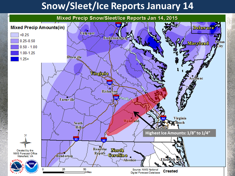
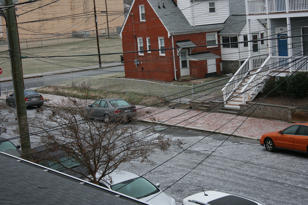
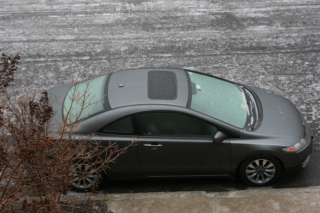
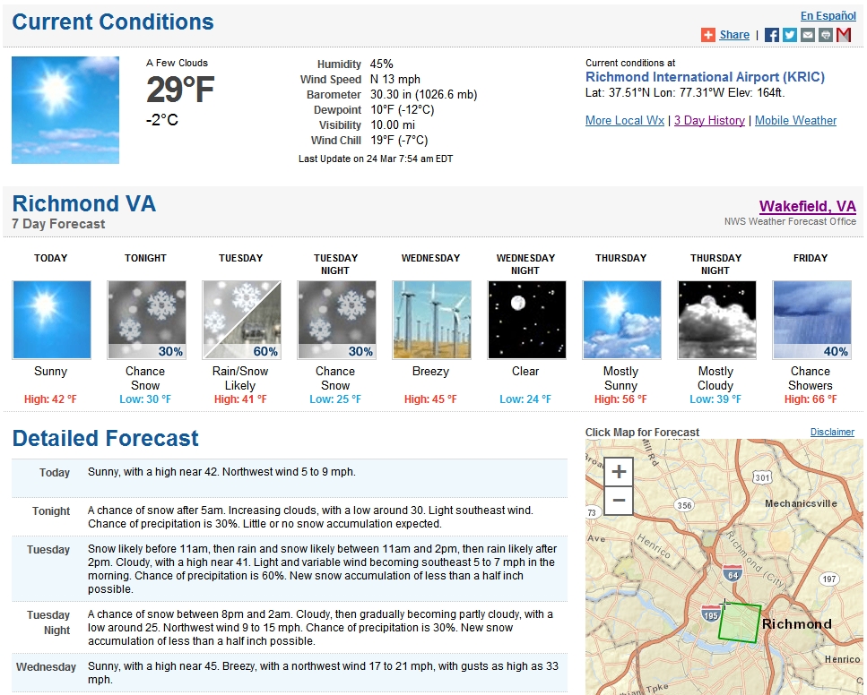
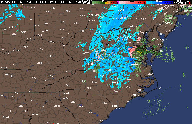
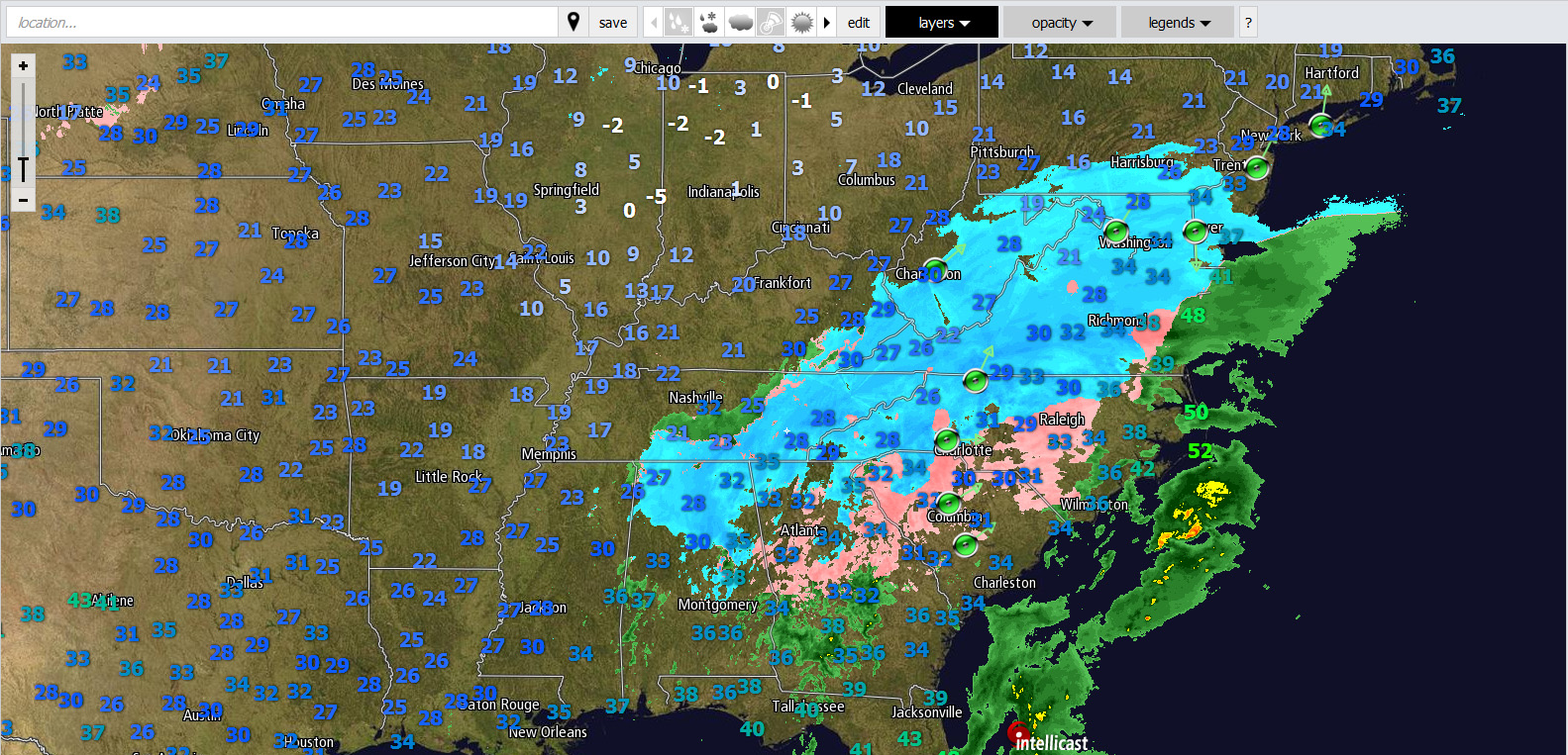
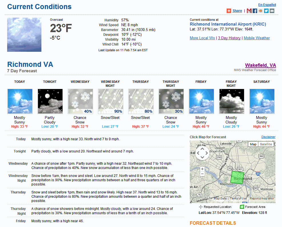
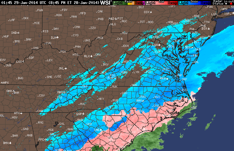
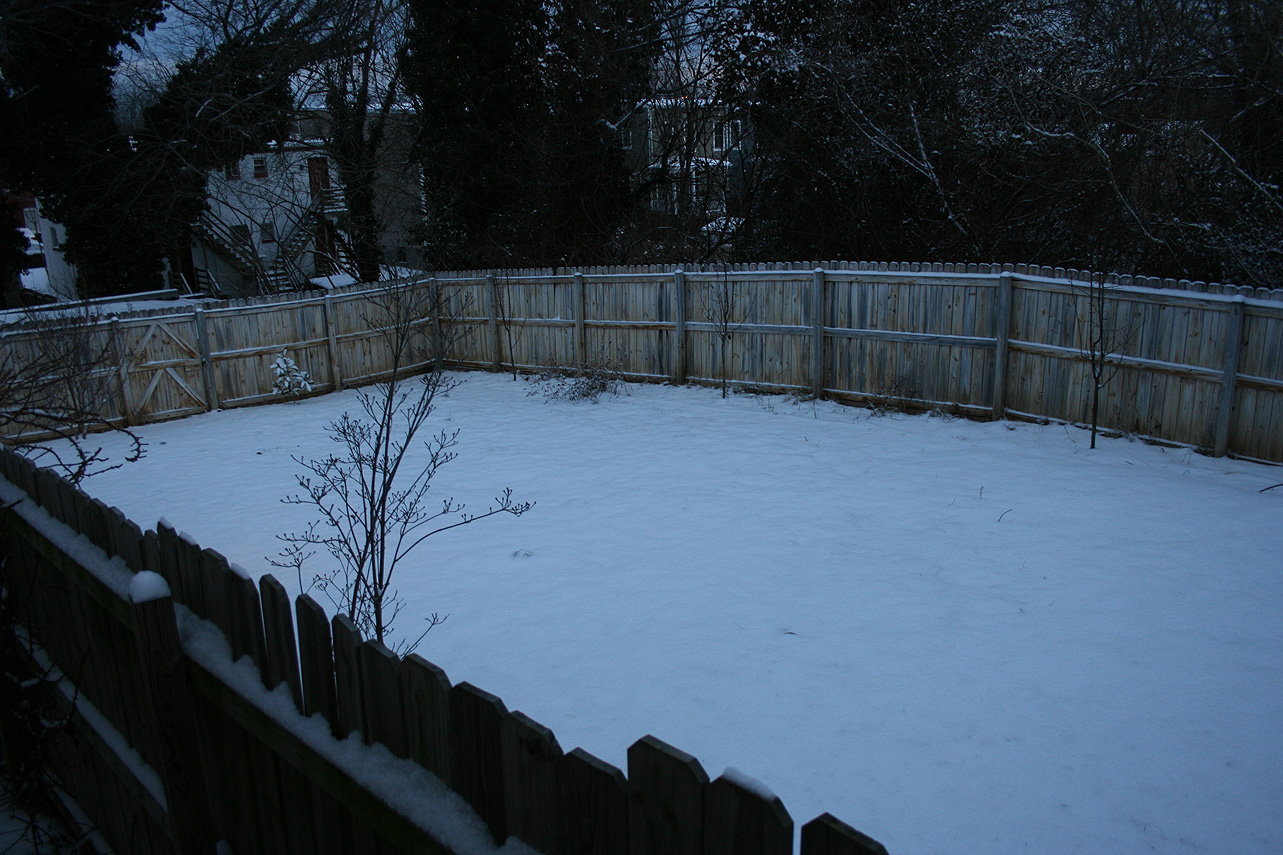
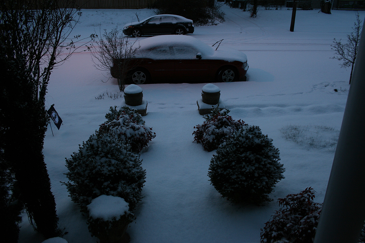
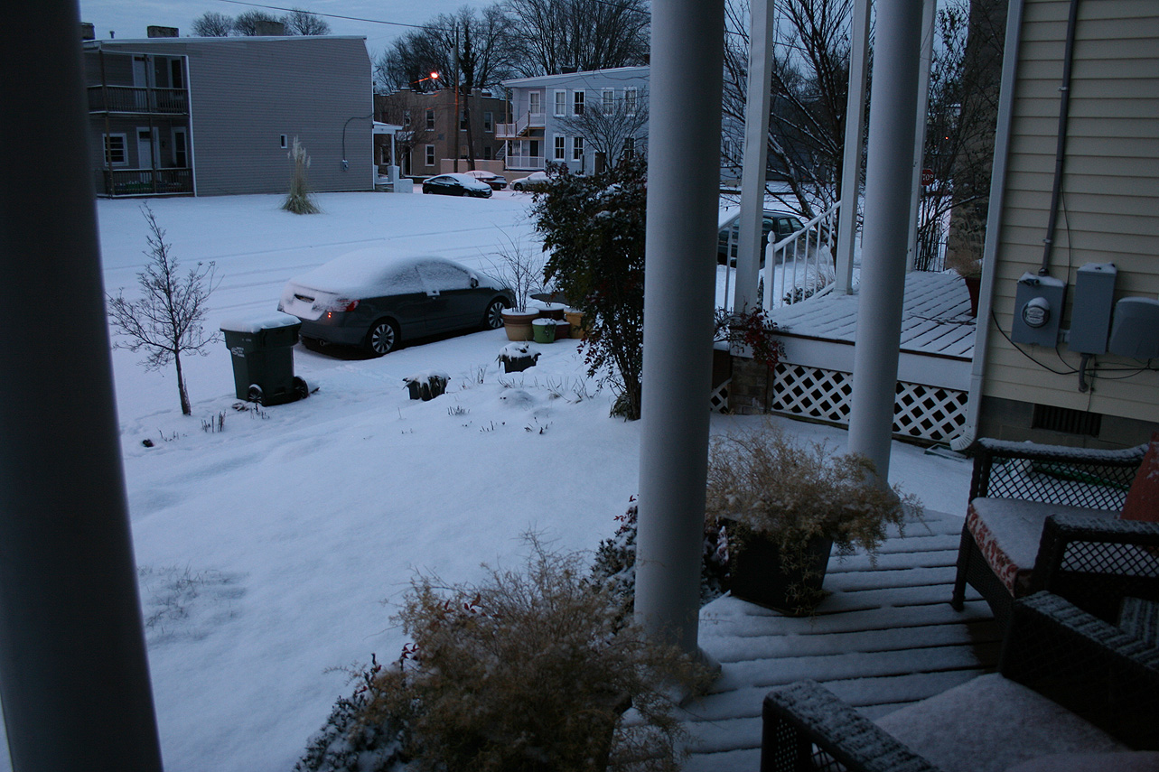
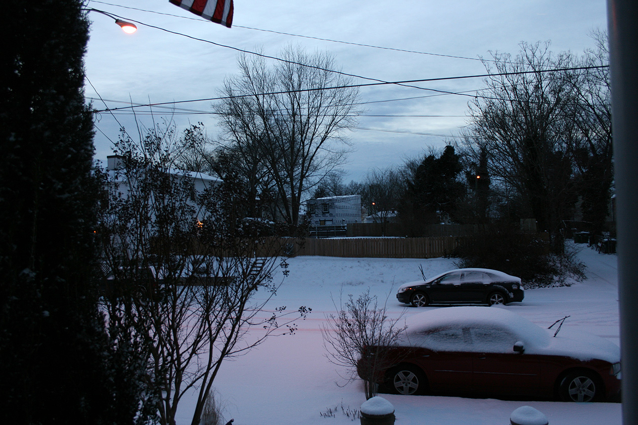
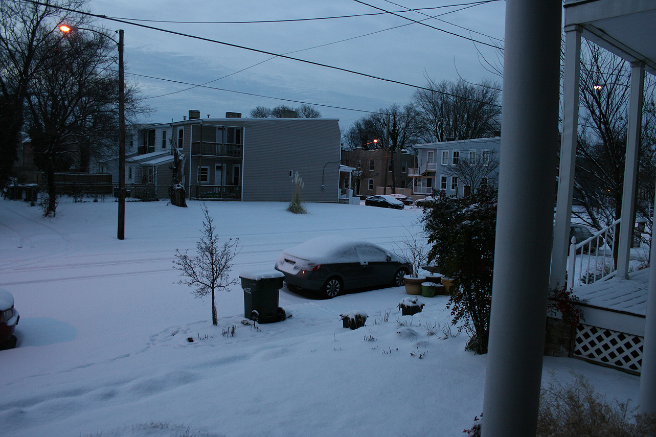
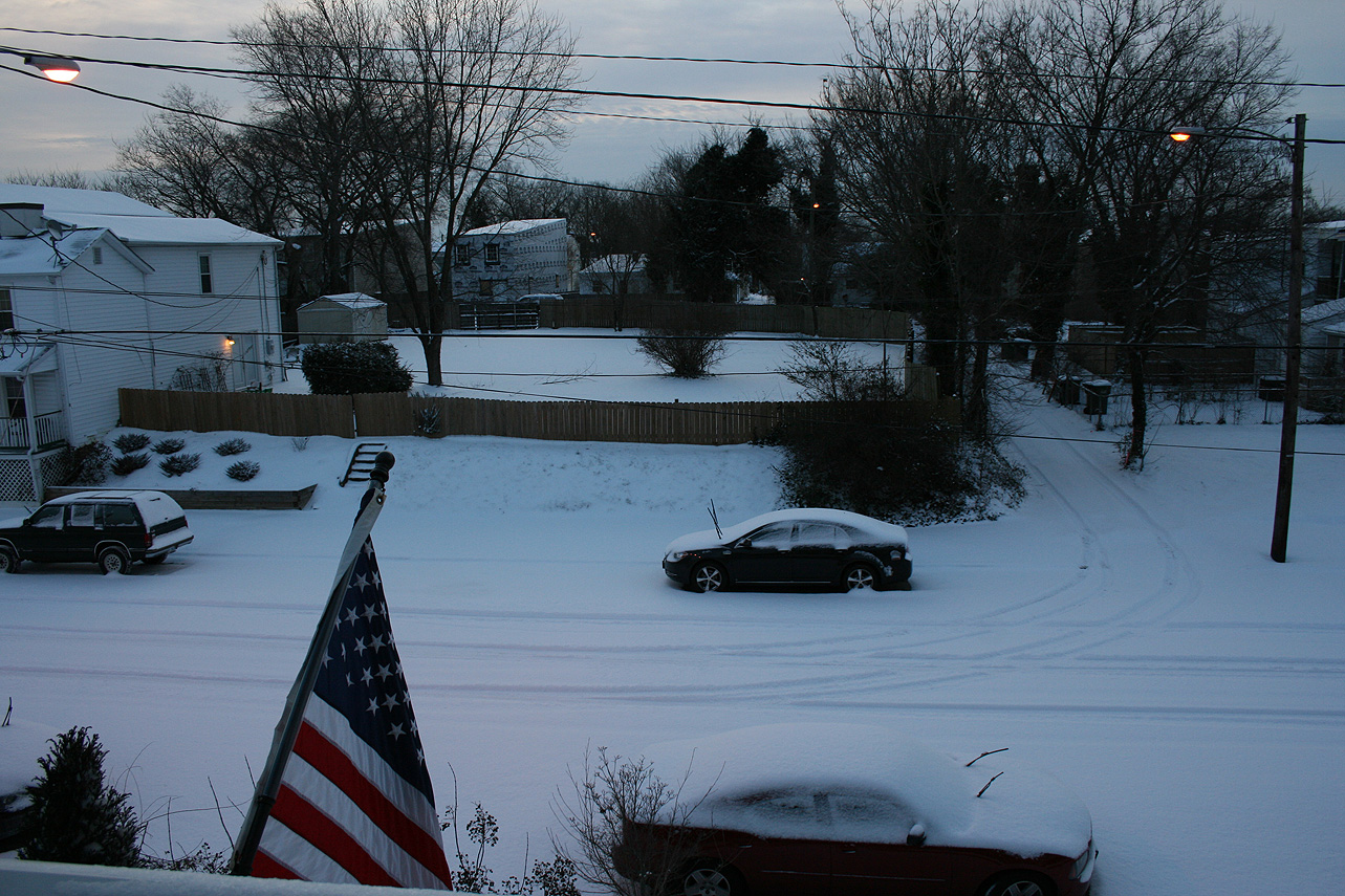
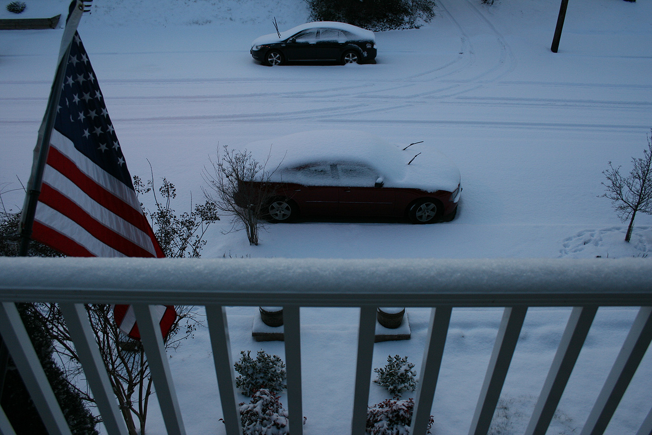
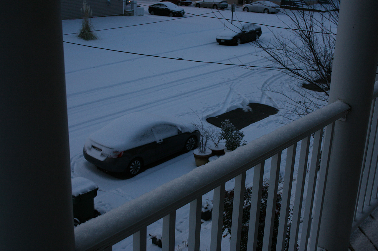
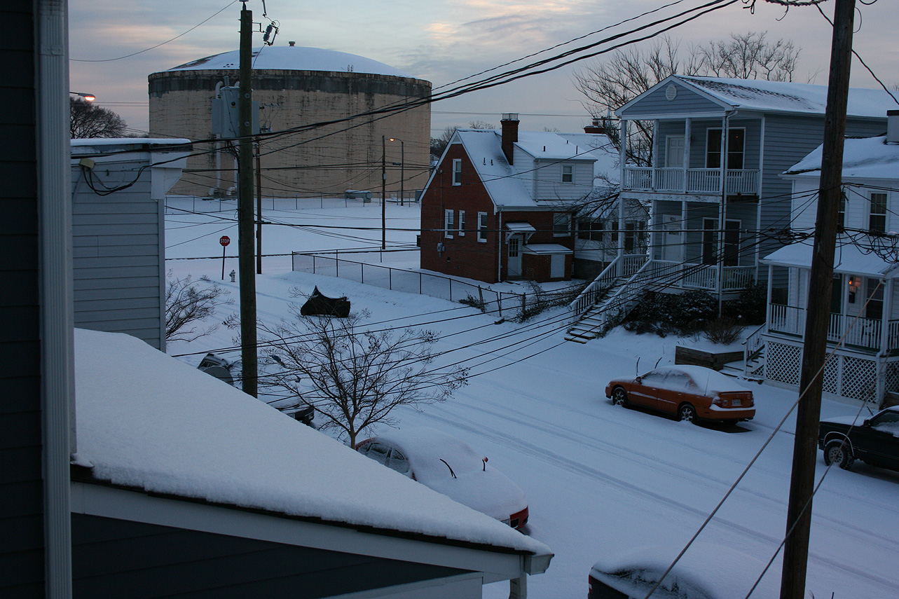
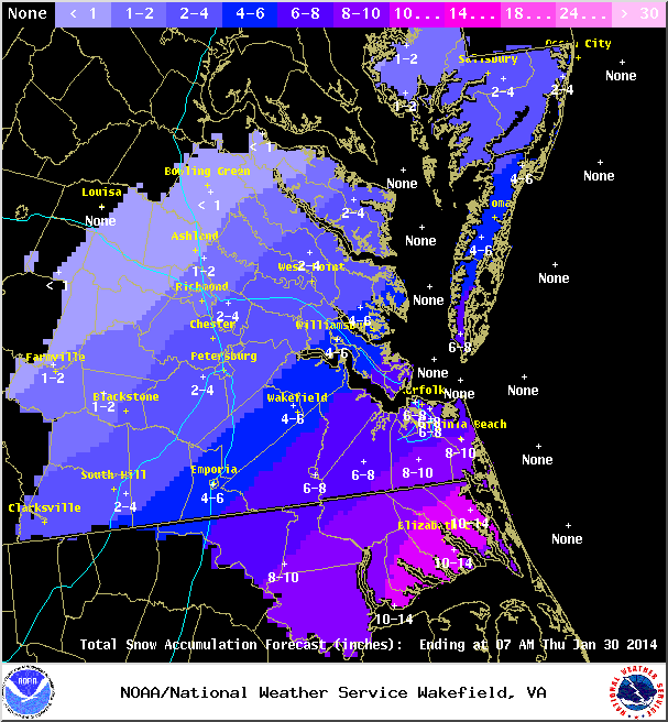
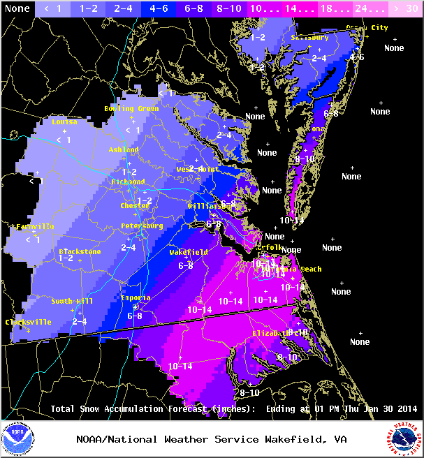
Another 24 hours has passed and models still trending towards a complex weather system impacting the area tomorrow into Thursday morning. Below are some graphics on the storm system. In addition, language for the winter storm watch is also posted.

NWS Forecast from morning of 2/11/14,.
NWS Forecast from the morning of  2/11/14.
NWS Forecast from the morning of 2/11/14.


NWS Forecast Discussion:

.SHORT TERM /WEDNESDAY THROUGH THURSDAY NIGHT/…

— Changed Discussion —

SIGNIFICANT WINTER STORM PRIMED TO IMPACT THE REGION LATE

WEDNESDAY THROUGH THE DAY THURSDAY…


OVERVIEW…

MODELS HAVE COME INTO GOOD AGREEMENT AS AFOREMENTIONED NRN AND SRN

STREAM ENERGY WL PHASE INTO A POTENT SHORTWAVE OVER THE GULF STATES

WED/WED NIGHT. CLOUDS WILL INCREASE LATE TONIGHT AND EARLY WED AS

THE SYSTEM APPROACHES FROM THE SOUTH. CYCLOGENESIS IS EXPECTED TO

OCCUR OVER THE NERN GULF WED PM, AS AMPLIFYING FLOW BEGINS TO LIFT

MOISTURE NWD. SFC HIGH PRESSURE TO THE NORTH WILL BEGIN TO

RETREAT…BUT WILL REMAIN RIDGED DOWN ACROSS NORTH CENTRAL VA.

STRONG SPEED MAX WILL EMERGE FROM THE BASE OF THE SHORTWAVE…FURTHER

ENHANCING THE FLOW OVER THE SE, WHICH WILL SERVE TO EJECT THE

SHORTWAVE NE. A WINTER STORM WATCH REMAINS IN EFFECT FOR THE CWA

WITH THE EXCEPTION OF THE SOUTHERN TIDEWATER AND NE NC. IF CURRENT

TRENDS HOLD WITH 12Z SUITE, UPGRADES TO WARNINGS/ADVISORIES WOULD

BE NEEDED TODAY OR THIS EVENING. MANY FACETS TO THIS EVENT…WHICH

BREAK DOWN AS FOLLOWS:


PRECIPITATION…

MODEL CONSENSUS HAS SLOWED ONSET OF PCPN BY A FEW HOURS, BUT

GIVEN THAT WAA PRECIP/OVERRUNNING IS OFTEN REALIZED QUICKER THAN

MODELS INDICATE, DID NOT CHANGE ONSET TIMING FROM PREVIOUS

FORECAST. MODELS IN GENERAL AGREEMENT WITH THE TRACK OF THE SFC

LOW…LIFTING IT ALONG THE SE COAST LATE WED TO JUST OFFSHORE LATE

WED NIGHT-EARLY THURS MORNING. 11/00Z ECMWF TRACKS THE LOW ALONG

THE SE COASTAL PLAIN AND INTO SE VA/NE NC THU MORNING.


CHC POP WED MORNING/AFTN RAMP UP TO CATEGORICAL POPS WED AFTN/NIGHT

AS THE POTENT SHORTWAVE AND STRONG WINDS ALOFT PROVIDE DYNAMICAL

FORCING FOR ASCENT (STRONG AGEOSTROPHIC LIFT) OVER THE MID-

ATLANTIC. STRONG HEIGHT FALLS WILL ALSO PRODUCE STRONG Q-VECTOR

CONVERGENCE/FRONTOGENETIC FORCING OVER THE REGION (STRONGEST

BETWEEN H6-7). THIS RESULTS IN PERIODS OF MODERATE PRECIP

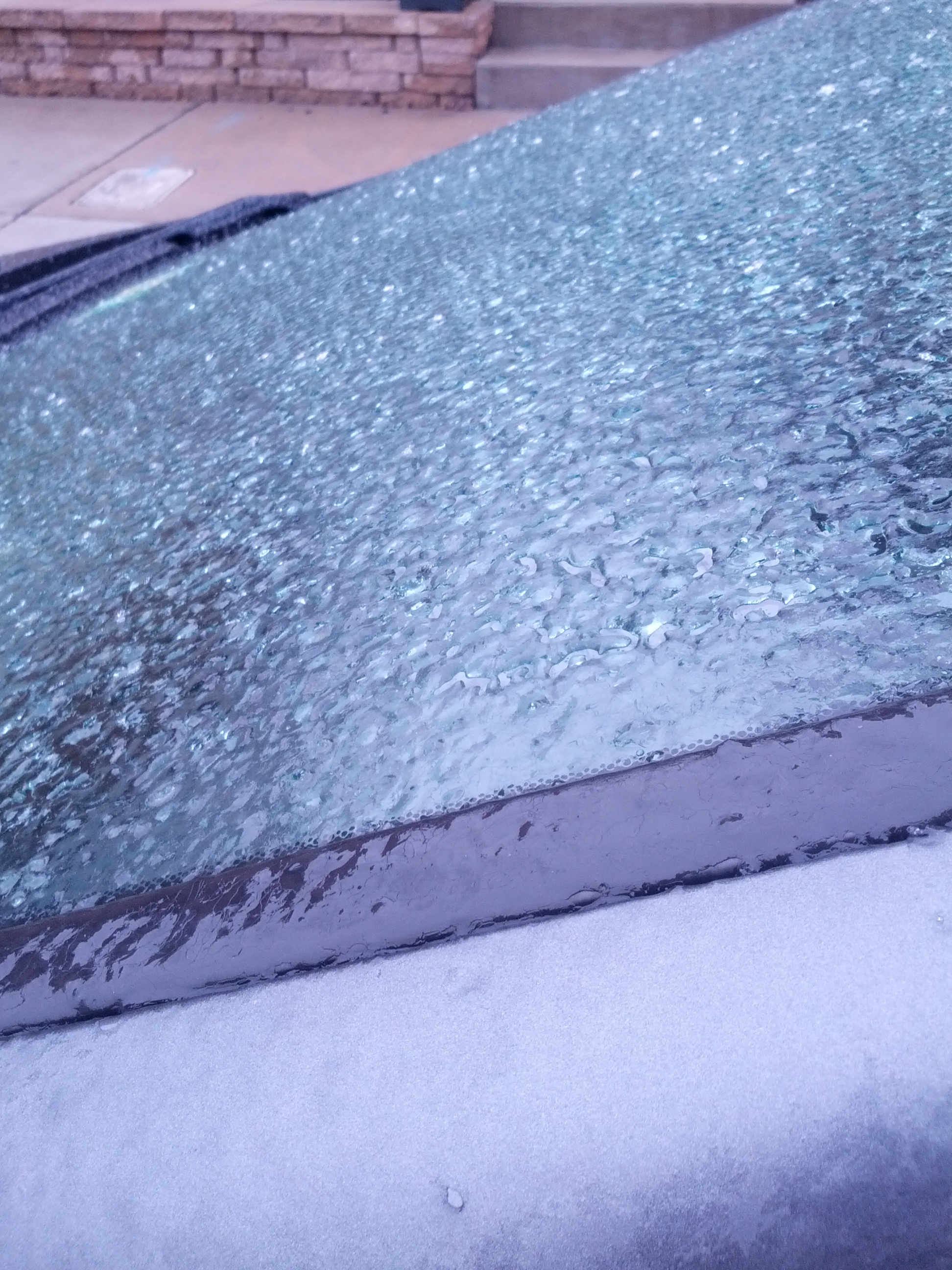
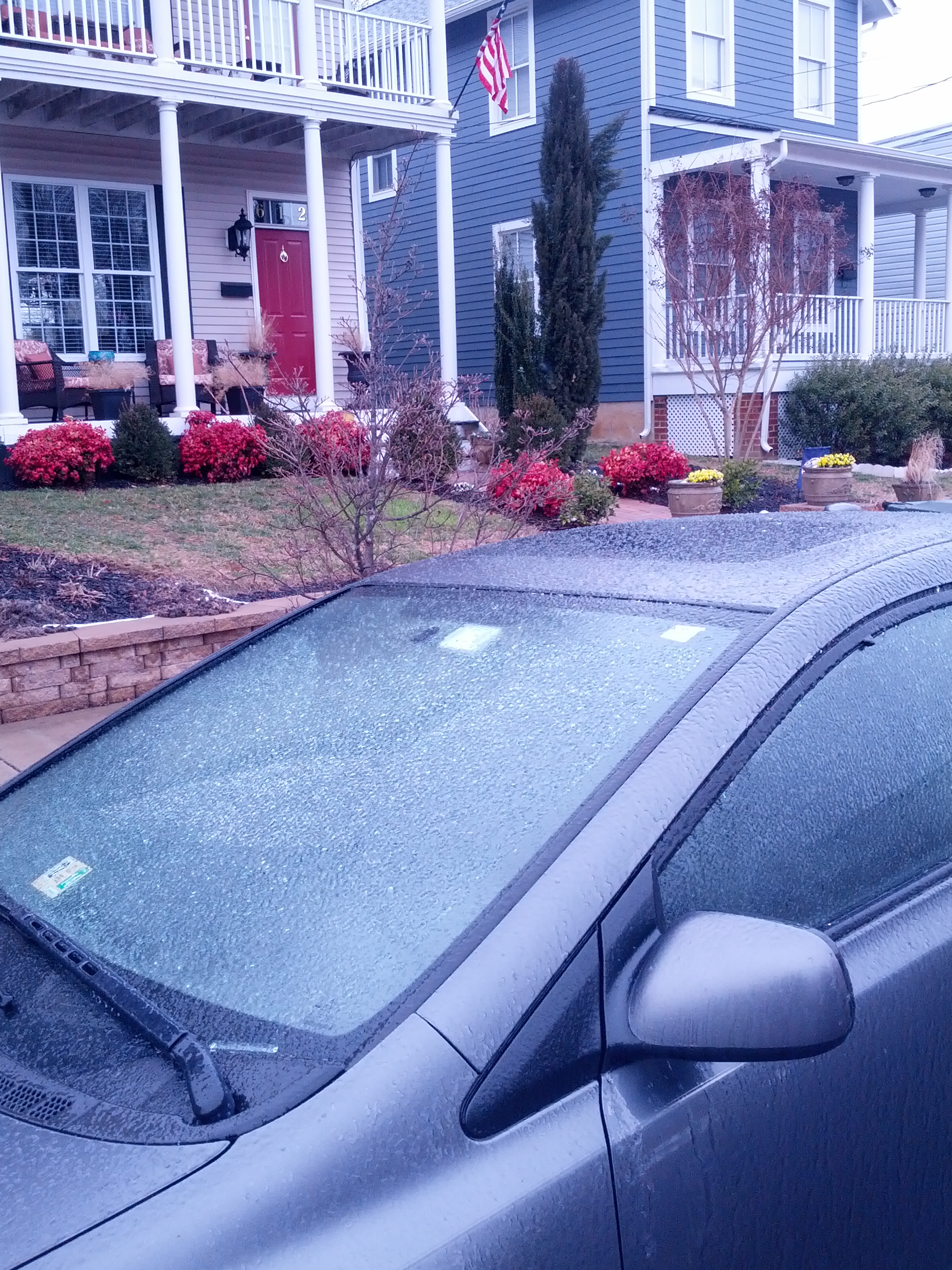
UNDERNEATH THIS BANDING. PRECIP WILL BEGIN AS ALL SNOW FOR ALL BUT

FAR SE WHERE TEMPS WILL BE WARM ENOUGH FOR RAIN…POSSIBLY A BRIEF

PERIOD OF SLEET AS LAYER MOISTENING ENSUES. THE PERIOD OF HEAVIEST

SNOWFALL LOOKS TO BE WED EVENING INTO EARLY THU MORNING. SFC LOW

APPROACHES COASTAL PLAIN FROM THE SOUTH, AND WARM AIR MOVING IN

ALOFT SHOULD START MIXING IN SOME SLEET, EVENTUALLY CHANGING THE

SNOW OVER TO SLEET OR R/ZR PER BUFR SOUNDINGS. PRECIP WILL BEGIN

TO TRANSITION TO ALL RAIN OVER THE SE…BUT REMAIN ALL SNOW OVER

THE PIEDMONT. A MIXED BAG OF PRECIP FROM SOUTH CENTRAL VA INTO

EAST-CENTRAL VA (MAINLY I-95 EAST) AS A WARM NOSE WARMS TEMPS TO

~2-4C BTWN 950 AND 850MB. THIS WILL PRODUCE PERIODS OF

SNOW/SLEET/RAIN/FREEZING RAIN. STILL TOO EARLY TO IRON OUT EXACT

PTYPES IN THIS TRANSITION ZONE…BUT IT SEEMS VERY POSSIBLE THAT

THERE COULD BE ACCUMULATING ICE ON TOP OF SEVERAL INCHES OF SNOW

OVER CNTRL VA. DRY AIR WILL BEGIN TO PUNCH INTO THE SE AS THE LOW

LOCATES JUST OFF THE VA COAST THU MORNING, WHICH WILL EVENTUALLY

TURN INTO JUST LGT RA/DZ ACROSS THE SE AS MOISTURE ALOFT SLACKENS.

MEANWHILE, MOISTURE AXIS WILL LOCATE FROM THE PIEDMONT INTO NRN VA

AND THE MD ERN SHORE. MODELS INDICATE STRONG DYNAMICS IN THIS

MOISTURE AXIS WITH STRONG LIFT IN THE SNOW GROWTH LEVEL. MODEL GEO

POT VORT IS ALSO NEGATIVE IN THIS REGION…WHICH ALSO PORTENDS TO

POSSIBLY ENHANCING BANDING BEHIND THE DEPARTING LOW. WILL MAINTAIN

LIKELY POPS ACROSS THE REGION THURS AFTERNOON AS THE PV ANOMALY

CATCHES UP WITH THE LOW. THIS WILL CAUSE THE LOW TO OCCLUDE AND

SLOW ITS FORWARD PROGRESS. WILL NEED TO MONITOR THIS AREA AS TEMPS

MAY BE WARM ENOUGH FOR RAIN…BUT DYNAMIC COOLING MAY TRANSITION

IT BACK TO SNOW BEFORE PCPN TAPERS OFF.


TEMPERATURE…

OBVIOUSLY DEPENDANT ON EXACT TRACK. USED A BLENDED SOLUTION FROM THE

ECMWF/CMC/NAM (BLENDED IN THAT ORDER) FOR TEMPS/THICKNESSES.

OPERATIONAL ECMWF WAS A SHADE EAST IN THIS LAST 00Z RUN…AND HENCE

THE FORECAST HAS SHIFTED THE MIXED PRECIP AXIS FARTHER WEST. HIGHS

WED GENERALLY IN THE L30S INLAND…TO U30S IMMEDIATE COAST. LOWS WED

NIGHT IN THE 20S NW TO MID 30S SE. IGNORED NUMERICAL GUIDANCE FOR

MAXIMA ON THU FORECAST AS THEY ARE TYPICALLY TOO HIGH IN ONGOING

PCPN. UNDERCUT GUIDANCE AND KEPT HIGHS IN THE MID 30S INLAND…TO

LOW 40S COASTAL AREAS.


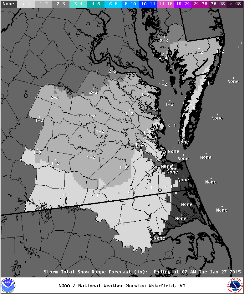
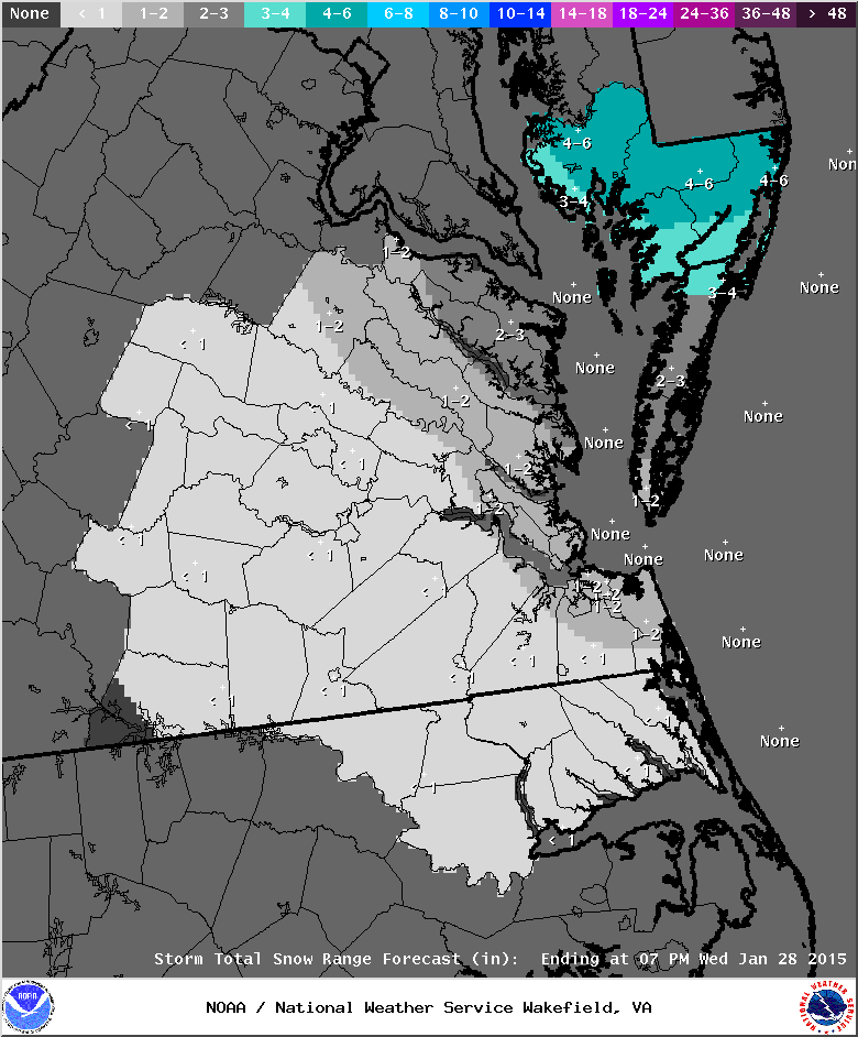
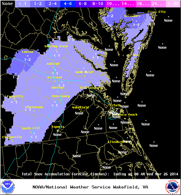
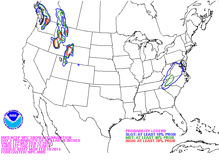
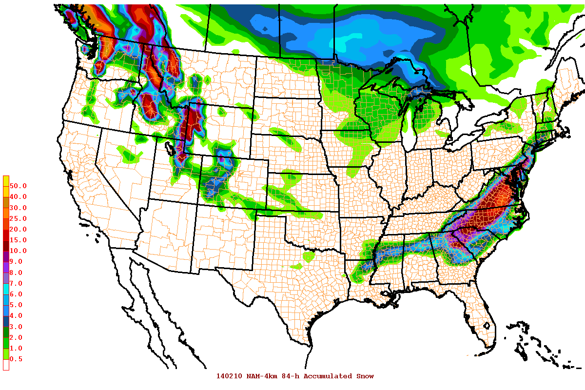
QPF/SNOWFALL TOTALS…

GENERALLY ACCEPTED WPC GUIDANCE FOR QPF AMOUNTS, THOUGH DID MIX IN A

BLEND OF AFOREMENTIONED MODEL GUIDANCE. QPF RANGE FROM ONE INCH NW

TO AN INCH AND THREE QUARTERS SE.


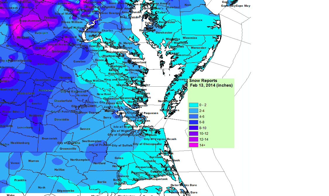
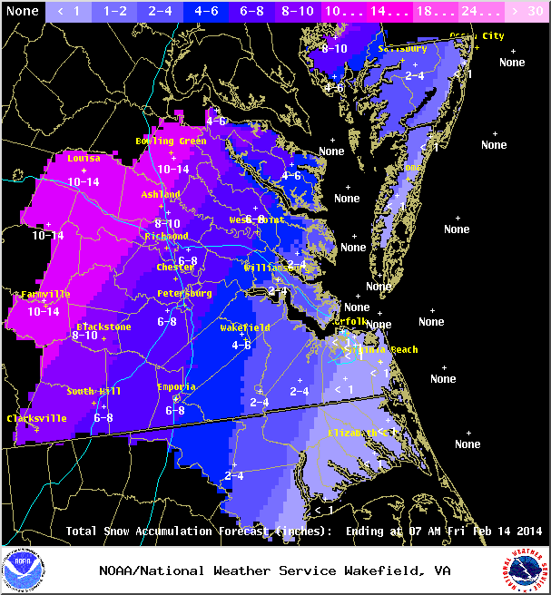
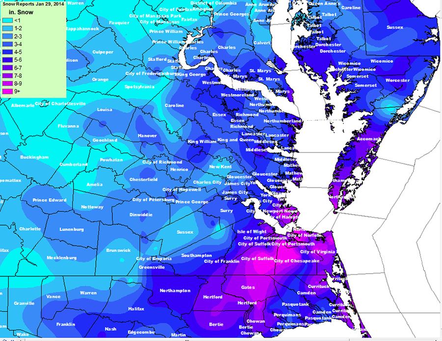
SNOWFALL AMOUNTS WILL RANGE FROM 10-14 INCHES OVER THE PIEDMONT

(ALL SNOW) TO 5-10 INCHES ALONG THE I-95 CORRIDOR…WITH 3-5″ FOR

THE NRN NECK/PENINSULA…WESTERN TIDEWATER AND INTR NE NC (LOWER

AMOUNTS IN CNTRL VA DUE TO WINTRY MIX). LITTLE…IF ANY

ACCUMULATION IN S/E TIDEWATER. IN MARYLAND, HIGHEST TOTALS WILL BE

IN USUAL SPOTS N/W OF 50 IN WICOMICO/DORCHESTER COUNTIES…WITH

MIXING RESULTING IN LOWER TOTALS ALONG AND EAST OF 13. PLEASE

REFER TO SNOWFALL GRAPHICS FOR MORE INFO.

— End Changed Discussion —

Winter Storm Watch:

URGENT – WINTER WEATHER MESSAGE
NATIONAL WEATHER SERVICE WAKEFIELD VA
1026 AM EST TUE FEB 11 2014

NCZ012-VAZ065-066-070-071-079>081-087>089-092-093-112330-
/O.CON.KAKQ.WS.A.0003.140212T1700Z-140213T2300Z/
NORTHAMPTON NC-MECKLENBURG-LUNENBURG-CHESTERFIELD-HENRICO-
BRUNSWICK-DINWIDDIE-PRINCE GEORGE-GREENSVILLE-SUSSEX-SURRY-
SOUTHAMPTON-ISLE OF WIGHT-
INCLUDING THE CITIES OF…MARGARETTSVILLE…SOUTH HILL…
COLONIAL HEIGHTS…RICHMOND…LAWRENCEVILLE…PETERSBURG…
HOPEWELL…EMPORIA…WAKEFIELD…FRANKLIN
1026 AM EST TUE FEB 11 2014

…WINTER STORM WATCH REMAINS IN EFFECT FROM WEDNESDAY AFTERNOON
THROUGH THURSDAY AFTERNOON…

A WINTER STORM WATCH REMAINS IN EFFECT FROM WEDNESDAY AFTERNOON
THROUGH THURSDAY AFTERNOON.

* LOCATIONS…PORTIONS OF CENTRAL AND EASTERN VIRGINIA.

* TIMING…LATE WEDNESDAY AFTERNOON THROUGH THURSDAY AFTERNOON.

* HAZARDS…HEAVY SNOW AND SLEET…POSSIBLY MIXED WITH FREEZING
  RAIN OVER EASTERN SECTIONS. A CHANGEOVER TO RAIN IS
  ANTICIPATED OVER EASTERNMOST SECTIONS OF THE WATCH AREA LATE
  WEDNESDAY NIGHT

* ACCUMULATIONS…THE POTENTIAL FOR 6 OR MORE INCHES OF SNOW…
  WITH HEAVIEST ACCUMULATIONS EXPECTED MAINLY ALONG AND WEST OF
  I- 95. A LIGHT ACCUMULATION OF ICE WILL ALSO BE POSSIBLE.

* IMPACTS…SNOW AND SLEET CAN LEAD TO SLICK AND HAZARDOUS
  TRAVEL CONDITIONS AS IT ACCUMULATES ON ROADWAYS. THE SNOW IS
  EXPECTED TO BE HEAVY AND WET…AND MAY WEIGH DOWN ON TREE
  LIMBS AND POWER LINES. SPORADIC POWER OUTAGES ARE POSSIBLE.

PRECAUTIONARY/PREPAREDNESS ACTIONS…

A WINTER STORM WATCH MEANS THERE IS A POTENTIAL FOR SIGNIFICANT
SNOW…SLEET…OR ICE ACCUMULATIONS THAT MAY IMPACT TRAVEL.
CONTINUE TO MONITOR THE LATEST FORECASTS.

February 12-13, 2014: Forecast for Heavy Snow to Mix?

Chance of more than 8" of snow on Day 3, NWS
Chance of more than 8″ of snow on Day 3, NWS

The Eurpoean Weather model has been showing hints of a winter storm since last Thursday (2/6) for the middle of this week. As we are within 48 hours of the storm, several more weather models are on board with a significant storm scenario for Central Virginia. While it is still early to issue snowfall forecasts, certain models have pegged Richmond for as much as 6″ to 25″ of snow. A wide range that can vary based on the track and intensity of the storm.

NAM 12Z 84-Hour Snowfall Accumulation

The NAM model above is likely overdone in snow totals since it is projecting totals for the later hours of its run (shown for the novelity factor only).

URGENT - WINTER WEATHER MESSAGE
NATIONAL WEATHER SERVICE WAKEFIELD VA
410 PM EST MON FEB 10 2014

NCZ012-VAZ065-066-070-071-079>081-087>089-092-093-111200-
/O.NEW.KAKQ.WS.A.0003.140212T1700Z-140213T2300Z/
NORTHAMPTON NC-MECKLENBURG-LUNENBURG-CHESTERFIELD-HENRICO-
BRUNSWICK-DINWIDDIE-PRINCE GEORGE-GREENSVILLE-SUSSEX-SURRY-
SOUTHAMPTON-ISLE OF WIGHT-
INCLUDING THE CITIES OF...MARGARETTSVILLE...SOUTH HILL...
COLONIAL HEIGHTS...RICHMOND...LAWRENCEVILLE...PETERSBURG...
HOPEWELL...EMPORIA...WAKEFIELD...FRANKLIN
410 PM EST MON FEB 10 2014

...WINTER STORM WATCH IN EFFECT FROM WEDNESDAY AFTERNOON THROUGH
THURSDAY AFTERNOON...

THE NATIONAL WEATHER SERVICE IN WAKEFIELD HAS ISSUED A WINTER
STORM WATCH...WHICH IS IN EFFECT FROM WEDNESDAY AFTERNOON THROUGH
THURSDAY AFTERNOON.

* LOCATIONS...PORTIONS OF CENTRAL AND EASTERN VIRGINIA.

* TIMING...WEDNESDAY AFTERNOON THROUGH THURSDAY AFTERNOON.

* HAZARDS...SNOW AND SLEET...POSSIBLY MIXED WITH FREEZING RAIN.
  MUCH OF THIS AREA WILL CHANGE TO MAINLY RAIN ON THURSDAY.

* ACCUMULATIONS...THE POTENTIAL FOR 4 OR MORE INCHES OF
  SNOW...ALONG WITH A LIGHT ACCUMULATION OF ICE.

* IMPACTS...SNOW AND SLEET CAN LEAD TO SLICK AND HAZARDOUS TRAVEL
  CONDITIONS AS IT ACCUMULATES ON ROADWAYS. THE SNOW IS EXPECTED TO
  BE HEAVY AND WET...AND MAY WEIGH DOWN ON TREE LIMBS AND POWER
  LINES. SPORADIC POWER OUTAGES ARE POSSIBLE.

PRECAUTIONARY/PREPAREDNESS ACTIONS...

A WINTER STORM WATCH MEANS THERE IS A POTENTIAL FOR SIGNIFICANT
SNOW...SLEET...OR ICE ACCUMULATIONS THAT MAY IMPACT TRAVEL.
CONTINUE TO MONITOR THE LATEST FORECASTS.

February 8, 2014: Light Snow?

NWS Forecast, 2/7/2014

NWS Forecast Discussion:

.SHORT TERM /6 PM THIS EVENING THROUGH SUNDAY/…
THE NEXT IN THE SERIES OF SHORTWAVES ALOFT APPROACHES FM THE WSW
TNGT…THEN TRACKS ACRS THE FA ON SAT. MDL TRENDS CONT TO SUGGEST
THAT THERE WILL BE A HI PROB FOR PCPN…BEGINNING LT TNGT W…AND
ACRS MUCH OF THE FA ON SAT. WK SFC LO PRES ONCE AGN PASSES BY WELL
S OF THE RGN ON SAT…WHILE SHEARED OUT S/W ALOFT CROSSES THE
NRN/CNTRL PORTION OF THE FA. WILL CONT W/ IDEA OF POPS FM HI CHC
TO LIKELY…W/ HIGHEST QPF ACRS SE VA/NE NC. P-TYPE WILL BE
CHALLENGING…AS BOUNDARY LAYER WILL BE NR/ABV 32F EXCEPT OVER
THE INTERIOR (EARLY) IN THE AM HRS. WILL HAVE MNLY RA FOR SE VA/NE
NC…W/ MIXED P-TYPE IN A NARROW RIBBON (FM ENE TO WSW) IN BETWEEN
THAT RA…AND A PD OF SN ACRS NRN SECTIONS OF THE FA. PCPN
COVERAGE XPCD TO DECREASE DURG SAT AFTN/EVE. SN ACCUMS ATTM (MNLY
ALG-NW OF A FVX TO SBY LN) LIMITED TO AN INCH OR LESS. OTRWMNLY
CLDY FOR THE DAY…HI TEMPS FM THE U30S ACRS THE N…TO THE M40S
S.

January 28-29, 2014: Observations

Event Updates:

As of 9:00 PM on 1/28, there is approximately 1″ of snow on all surfaces in Church Hill. Temperature continues to slowly fall and is hovering at 15.4 degrees Fahrenheit.

Radar at 9 PM on 1/28/2014

Church Hill Storm Observation Summary:
* Place – Time: Church Hill, (1/30/2014)
* Temperature: 12-20, During Event
* Dewpoint: 1-10, During Event
* Relative Humidity: N/A%
* Winter Weather Watch/Warning/Advisory: Advisory
* Road Conditions: All roads covered during event, primary roads cleared by the morning of 1/22. However, secondary roads were still partially snow covered for 2-3 days after event.
* Precipitation Description: Very small snowflakes. Event remained all snow. Snow was so light that it could be swept off of hard surfaces.
* Total Precipitation: 2 and 1/2” (2.5”) of snow. Liquid equivalent of 0.14” fell during the event, which equates to a snow ration of 1:17.9! 2″ to 3″ fell across metro area. 3.1 inches of snow was reported at the airport. Snowfall totals were heavier towards the Bay and Hampton Roads area (6-10” was common).
* Comments: The snow began around the metro area around 3:30-4 PM. Temperatures dropped during the day (due to the passage of an arctic front) and snowfall was light during the entire event. A low tracking off the NC coast spread precipitation into most of Virginia. Wind during the event, averaging 5 MPH or less, was light. Accumulations were present on most surfaces. Snow was measured in the backyard of the house. Snow continued until about 4 AM on January 29th where the temperature dropped to nearly 10 degrees. By far, one of the coldest snow events I’ve witnessed. There was a 1.5 hour delay for Chesterfield County Government Offices.

Snowfall Totals:

NWS Snowfall Totals for 1/29/2014

Videos:

Photos:

January 28-29, 2014: Snow Forecast

A complex system may impact Central Virginia where anything but model consensus can be found. A low pressure developing on the edge of an arctic front will cause widespread snow from southern Texas to the Middle Atlantic. Models have slowly increased precipitation around metro Richmond in the 24-hours leading up to the event. Still, most of the precipitation will likely be south and east of the metro area (VA beach could easily see 6-12″ of snow) which is located closer to the low off the Hatteras coast.

Below are some forecast images from the NWS. The forecast has evolved over the last 2 days from a chance at flurries to around 1-2″ of snow in Metro Richmond.

Snow Forecast from NWS on 1/27/14.
NWS Forecast Totals, Updated at 9 PM on 1/28/14.