Deprecated: Optional parameter $selected declared before required parameter $args is implicitly treated as a required parameter in /home/richmon/domains/richmondcitywatch.com/public_html/rvawx_test/wp-content/plugins/archives-calendar-widget/arw-settings.php on line 178
Deprecated: Optional parameter $view declared before required parameter $args is implicitly treated as a required parameter in /home/richmon/domains/richmondcitywatch.com/public_html/rvawx_test/wp-content/plugins/archives-calendar-widget/arw-widget.php on line 480
Deprecated: Optional parameter $archiveMonth declared before required parameter $args is implicitly treated as a required parameter in /home/richmon/domains/richmondcitywatch.com/public_html/rvawx_test/wp-content/plugins/archives-calendar-widget/arw-widget.php on line 480
Warning: Trying to access array offset on value of type bool in /home/richmon/domains/richmondcitywatch.com/public_html/rvawx_test/wp-content/plugins/archives-calendar-widget/archives-calendar.php on line 64 Observation | RVAWX.com | Page 7
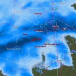
An impressive band of moisture has set up over Metro Richmond these evening. An upper level low coming out the great lakes has made spun some moisture over the mountains and we have has some impressive snowfall this evening. Already a dusting of snow is on most surfaces and the snow appears to be sticking around for the next few hours. Maybe 1/2″ to 1″ might be possible?
URGENT - WINTER WEATHER MESSAGE
NATIONAL WEATHER SERVICE WAKEFIELD VA
311 PM EST WED DEC 15 2010
...SNOW...POSSIBLY MIXED WITH SLEET AND LIGHT FREEZING RAIN LATE
TONIGHT AND THURSDAY...
THE NATIONAL WEATHER SERVICE IN WAKEFIELD HAS ISSUED A WINTER
STORM WARNING FOR HEAVY SNOW...WHICH IS IN EFFECT FROM 4 AM TO 7 PM
EST THURSDAY. THE WINTER STORM WATCH IS NO LONGER IN EFFECT.
* ACCUMULATION...2 TO 5 INCHES OF SNOW.
* ICE AMOUNTS...A TRACE TO ONE TENTH OF AN INCH OF ICE IS
POSSIBLE...MAINLY TOWARD THE NORTH CAROLINA BORDER THURSDAY
AFTERNOON AND EVENING.
* TIMING: LATE TONIGHT THROUGH THURSDAY EVENING.
* IMPACTS: HAZARDOUS TRAVEL CONDITIONS.
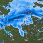
12/15 9:00PM: Not much has changed in the past few hours in terms of the forecast. Some areas to the west had the snow totals increased to 3-7″
The main precip shield is still just west of the Apps, and, amazingly, it stretches NW up to Bismark!
Well, this weekend’s system looks more and more like an all rain event for us here in the Richmond Metro area. Temperatures will remain in the low to mid 40’s and may warm up a bit more before some precipitation moves in some time after 1pm Saturday. This light rain will come up from the south, and is not from the main rain event.
updated 10:50PM 12/12
This rain will bring showers to the area and become a steady light rain from 8pm until around 4 or 5am Sunday morning. The rain will become more steady and continue through the day Sunday until about 7 or 8pm.
A rapid drop in temperature will occur, dropping from about 47* at about 6pm Sunday, to around 26* by 6am Monday morning. Black ice will be an issue for early travelers.
There is still a slight chance of wraparound moisture from the system bringing a few flakes to the area. At most, a light dusting could occur for us here, while places east of I-95 may see slightly more.
Total rain amounts should vary between 0.5″ to 0.75″ in most places, with a few places see locally around 1.00″.
Read for real time updates during the event and for any changes in the forecast.
Next up: Next week’s big arctic blast and another storm? Could the timing be right for these to come together to bring Richmond Metro some snow and ice? Read later for more on this.
Cool WV Sat image of the storm. Classic coma shaped, with the front right behind that bright white band from LA to MI
Part 2
Well, the main storm hasn’t even arrived yet, but managed about 0.22″ of rain so far. The main wave will move in around late morning, and the rain will last through the early evening hours. Temperatures will remain well above freezing, getting into the low 40’s. As the system moves out, temperatures will drop as the cold front sweeps by. There may be enough moisture late evening to squeeze out a few flakes or a snow shower. These will mainly be hit-or-miss for Metro Richmond.
Storm Total Rain: 0.65″
Snow: Trace-0.25″
High Sunday: 46* dropping into the upper 20’s by early Monday AM
updated 3:00AM 12/12
Current & Historical Weather Events in Richmond, Virginia