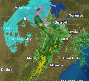
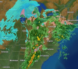
Well, this weekend’s system looks more and more like an all rain event for us here in the Richmond Metro area. Temperatures will remain in the low to mid 40’s and may warm up a bit more before some precipitation moves in some time after 1pm Saturday. This light rain will come up from the south, and is not from the main rain event.

This rain will bring showers to the area and become a steady light rain from 8pm until around 4 or 5am Sunday morning. The rain will become more steady and continue through the day Sunday until about 7 or 8pm.
A rapid drop in temperature will occur, dropping from about 47* at about 6pm Sunday, to around 26* by 6am Monday morning. Black ice will be an issue for early travelers.
There is still a slight chance of wraparound moisture from the system bringing a few flakes to the area. At most, a light dusting could occur for us here, while places east of I-95 may see slightly more.
Total rain amounts should vary between 0.5″ to 0.75″ in most places, with a few places see locally around 1.00″.
Read for real time updates during the event and for any changes in the forecast.
Next up: Next week’s big arctic blast and another storm? Could the timing be right for these to come together to bring Richmond Metro some snow and ice? Read later for more on this.
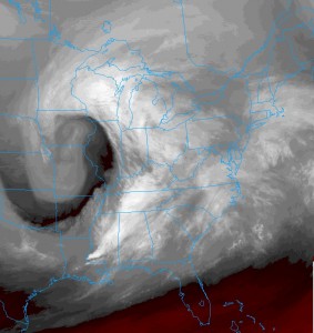
Cool WV Sat image of the storm. Classic coma shaped, with the front right behind that bright white band from LA to MI

Part 2
Well, the main storm hasn’t even arrived yet, but managed about 0.22″ of rain so far. The main wave will move in around late morning, and the rain will last through the early evening hours. Temperatures will remain well above freezing, getting into the low 40’s. As the system moves out, temperatures will drop as the cold front sweeps by. There may be enough moisture late evening to squeeze out a few flakes or a snow shower. These will mainly be hit-or-miss for Metro Richmond.
Storm Total Rain: 0.65″
Snow: Trace-0.25″
High Sunday: 46* dropping into the upper 20’s by early Monday AM

Russ’ Official Forecast: Through Monday AM
Rain: about 0.75″ (w/ spotty higher amounts of up to 1″)
Rain off and on today through Sunday, then steadier from Sunday noon until Sunday night around 7pm-9pm
Temps: 43* dropping to 36* by 10pm and remaining steady overnight. Temps will climb to near 47* Sunday before rapidly falling 32* by midnight. Monday will start off around 22*
Snow: Not likely here. If we do see any flake it will be Sunday evening and may amount to only a dusting to 0.25″
It started raining here at about 4:45pm with some drizzle. The intensity has picked up as a heavier shield moves across us. This light rain should only last a little more than an hour, then a break in the precip will occur at 6:30pm and the rain will pick back up by 10pm or so.
Light rain will occur overnight as the main system cranks in from the west. Rain will become more steady from mid-morning thru about 7pm Sunday. Temps will range from a high of 46* and fall to 35* by 10pm Sunday.
If any moisture is still around after 10pm Sunday, it could mean a few flakes or even a dusting to 0.25″ for us here in the metro area.
This is subject to change, and probably will, so stay tuned.
One thing worth noting…the temperature here has dropped 4.7* to 36.8* in an hour and a half. Let’s see how far it can drop before it starts climbing again…
Also, rain has picked up a bit too.
Cold rain is a certainty for Sunday. Pretty boring in a meteorological sense. The one to stay interested in this one is possibly some wraparound (leftover) moisture bringing a few snow showers tomorrow evening.
2 key items:
1. Moisture – How much will be left and how long will it hang around?
2. Temps – How quickly will they drop to the sub 33* mark we need for snow?
The way these play out will determine how much (if any) light snow could briefly fall.
I’ll keep a close eye on it.
The NWS just put us in a ‘Slight’ chance for snow very early Monday morning and into late morning. Next step would be a WWA, but if that does come, it most likely won’t be issued until late afternoon Sunday.
Keeping a close eye on this developing situation…