Deprecated: Optional parameter $selected declared before required parameter $args is implicitly treated as a required parameter in /home/richmon/domains/richmondcitywatch.com/public_html/rvawx_test/wp-content/plugins/archives-calendar-widget/arw-settings.php on line 178
Deprecated: Optional parameter $view declared before required parameter $args is implicitly treated as a required parameter in /home/richmon/domains/richmondcitywatch.com/public_html/rvawx_test/wp-content/plugins/archives-calendar-widget/arw-widget.php on line 480
Deprecated: Optional parameter $archiveMonth declared before required parameter $args is implicitly treated as a required parameter in /home/richmon/domains/richmondcitywatch.com/public_html/rvawx_test/wp-content/plugins/archives-calendar-widget/arw-widget.php on line 480
Warning: Trying to access array offset on value of type bool in /home/richmon/domains/richmondcitywatch.com/public_html/rvawx_test/wp-content/plugins/archives-calendar-widget/archives-calendar.php on line 64 Forecast Discussion | RVAWX.com | Page 7
The next weather headline coming our way this weekend involves a frontal boundary that will usher in a brief bout of arctic air for Sunday into Monday for Metro Richmond. As the frontal passage comes through, there is a small chance of the rain changing to snow in Central Virginia. It looks unlikely that any accumulating snow will fall from this event. The NWS has us recieving some rain showers and nothing else from the frontal passage. Nonetheless, it is a possible snow event to watch evolve over the next two days. In any case, a windy and winter like day is in store for Sunday (2/12/12).
It’s been one heck of a winter chasing snow. Now I’m really grasping for straws here, but there might be a possibility of some flurries this evening as the moisture from the system pulls away from the middle atlantic states. I’d rate the chance of seeing some snow this evening in the 5-10% chance.
Is there a viable chance for snow this weekend? Some models seem to be hinting at a colder solution that would allow for this weekend’s storm to end as a period of light sleet and snow. The 12Z NAM grazes the area with 1-2 inches of snow on early Sunday. The 12Z GFS keeps Metro Richmond on the warm side with 850 MB temperatures. The forecast looks anything but certain at this point as the cut-off low from the mid-west drifts towards the mid-atlantic late tomorrow into Sunday.
Current Radar:
Update (2/6/2012):
No snow or flurries appeared this weekend. The moisture raced out of Metro Richmond by 2-3 AM. Sunday remained mostly cloudy. The snow drought continues.
Severe weather may be possible tonight with an approaching cold front from the west. The NWS has classified areas south of Richmond with a 2% chance of seeing tornadoes during the overnight hours. Wind damage is also a possibility if a squall line develops tonight.
* Place – Time: Church Hill, 8 PM -12 AM(1/20/2012)
* Temperature: 37 (Falling to 31)
* Dewpoint: 24-32 (Rising)
* Relative Humidity: N/A
* Pressure: N/A
* Trends: Event started as light snow, which quickly turned to sleet and freezing rain.
* Precipitation Description: Snow, to sleet, to freezing rain and finally rain.
* Total Precip: Light coating of ice on cars, trees and elevated surfaces.
* Comments: Moisture arrived from the south and west and started as a little bit of light snow and sleet mix. The mix quickly converted over to sleet and freezing rain. Freeing rain lasted until 12 AM before turning over to light rain. Close to half an inch (0.48 as of 1/21/2012) of rain fell. No significant or measurable ice fell in Richmond.
Another fast moving clipper combined with a low-pressure system developing in the lower plains/Tennessee Valley will give the Richmond area a chance of sleet/rain mix this evening into early Saturday morning. The local meteorologists have hinted at this possible scenario for about two days now and have kept it in the forecast.
No accumulating snow is expected at this point. It looks like you will have to go as far north as Maryland (maybe DC/NOVA) to see any appreciable accumulation of snow or ice.
Normally this type of event would not be worth commenting on. However, Richmond has not seen any accumulating snow as of today (1/20/2012) or in any of the previous months of this winter season. Therefore, there is a little excitement in the air to have the possibility of even a small wintry event tonight into tomorrow morning.
NBC12 has also hinted at a small chance of freezing rain tomorrow night (1/21 to 1/22) as another round of precipitation rolls in.
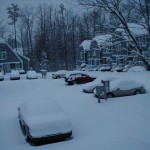
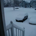
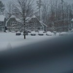
I ran across these photos today from a snowstorm that occurred on January 3, 2002. I believe the Richmond airport received 7.7″ of snow from this storm, which was a daily record for snowfall. These images were taken in Midlothian.
The first substantial chance of winter weather might be heading our way tomorrow night. The various models seem to point to an accumulating snow event along the Appalachian mountains. In Richmond, the NWS still has the metro area in 100% rain. Areas like Short Pump and Powhatan have a slight chance of the precipitation changing to snow.
The chance of accumulating snow for Richmond remains very low. However, we could see a rain to snow changeover on the tail end of the precipitation shield. This scenario will likely preclude any meaningful accumulation. It will be worth watching to see how the event pans out for Metro Richmond.
Today through Wednesday night should be cloudy with patchy drizzle. More significant rain will come Tuesday night and into Wednesday. A thunderstorm is possible on Wednesday as well with the passing of a cold front.
The cold front will bring more seasonal temps from Thursday through next week, with highs in the upper 50’s to mid 60’s and lows in the upper 30’s to mid 40’s.
The long range models are hinting at a chilly start to December. More to come on that later…
Late October is usually a transition period climatically for Central Virginia. The leaves are near peak foliage and the first frost usually occurs by the end of the month. Just in time for Halloween, the first frost and even the first appearance of wintry precipitation have appeared! On Friday, a major east coast storm system (nor’easter) charged up the coast giving Church Hill approximately 1.10″ of rain. Prior to the bulk of the moisture arriving, some light sleet pellets were observed in downtown Richmond on my way home from work. The pellets only lasted for a few minutes, but it was an interesting event given that it is still October and the air temperature at the surface was 44 degrees!
Winter 2011-2012 Statistics for Church Hill:
First Wintry Precipitation for 2011-2012 Winter Season in Church Hill: October 28, 2011.
First Frost for 2011-2012 Winter Season in Church Hill: October 30, 2011 (31.9 Degrees).
Morning Lows from October 31, 2011:
Current & Historical Weather Events in Richmond, Virginia