Deprecated: Optional parameter $selected declared before required parameter $args is implicitly treated as a required parameter in /home/richmon/domains/richmondcitywatch.com/public_html/rvawx_test/wp-content/plugins/archives-calendar-widget/arw-settings.php on line 178
Deprecated: Optional parameter $view declared before required parameter $args is implicitly treated as a required parameter in /home/richmon/domains/richmondcitywatch.com/public_html/rvawx_test/wp-content/plugins/archives-calendar-widget/arw-widget.php on line 480
Deprecated: Optional parameter $archiveMonth declared before required parameter $args is implicitly treated as a required parameter in /home/richmon/domains/richmondcitywatch.com/public_html/rvawx_test/wp-content/plugins/archives-calendar-widget/arw-widget.php on line 480
Warning: Trying to access array offset on value of type bool in /home/richmon/domains/richmondcitywatch.com/public_html/rvawx_test/wp-content/plugins/archives-calendar-widget/archives-calendar.php on line 64 Ryan_R | RVAWX.com | Page 11
It’s been one heck of a winter chasing snow. Now I’m really grasping for straws here, but there might be a possibility of some flurries this evening as the moisture from the system pulls away from the middle atlantic states. I’d rate the chance of seeing some snow this evening in the 5-10% chance.
Is there a viable chance for snow this weekend? Some models seem to be hinting at a colder solution that would allow for this weekend’s storm to end as a period of light sleet and snow. The 12Z NAM grazes the area with 1-2 inches of snow on early Sunday. The 12Z GFS keeps Metro Richmond on the warm side with 850 MB temperatures. The forecast looks anything but certain at this point as the cut-off low from the mid-west drifts towards the mid-atlantic late tomorrow into Sunday.
Current Radar:
Update (2/6/2012):
No snow or flurries appeared this weekend. The moisture raced out of Metro Richmond by 2-3 AM. Sunday remained mostly cloudy. The snow drought continues.
Name: December 18-19th Storm of 2009 (Peacock Day Storm)
Date: December 18-19, 2009
Precipitation Observed: 7.5” (Church Hill)
RIC Airport Total Snowfall Observation: 7.4”
Precipitation Type: Primarily Snow, followed by Sleet & Freezing Rain/Drizzle
Radar of the event from 12/19/2009, 1Z
The December 18-19th, 2009 snowstorm will mark the third winter storm to be profiled in a series of articles to be posted on our blog. We hope you find these weather event musings entertaining and factual. These articles will portray some of the most memorable snow events that Russ and I have lived through while residing in Richmond, Virginia.
Before the Storm: With the early March storm of 2009, expectations were running high for the start of the winter season of 2009-2010. By Thursday, December 17th, the NWS had issued a winter storm watch for Metro Richmond warning of a snow event that could drop 6 to 12 inches of snow. The anticipation of experiencing a major winter storm before the actual start of the astronomical winter season was rare. To put how rare December snowstorms are in Richmond, the NWS compiled a nice graphic ranking this storm to other December snowfalls:
Synoptic Overview of Storm System: A low pressure system developed over the Gulf Coast spawned a widespread snow event from north Georgia to the coastal sections of Maine. The first reference link below provides a much more detailed and analytical write-up of the system’s dynamics.
Video of Event from Church Hill (My Home):
The Main Event: This event started just after sunset on Friday, December 18th, lasting until the early morning hours of December 19th in Metro Richmond. Russ & I were anticipating this event several days before the first flake fell from the sky. I still have a fond memory of looking for the first flakes to fall while sitting at work. Just as it was time to leave work, snow began falling. The snow rate intensified at quick clip from 5 to 8 PM. Snow continued to fall at a high rate with little in the way of wind being observed through most of the evening hours. Prior to 11 PM on the 18th, the most intense part of the storm hit. The wind picked up slightly and the snowfall rate accelerated to over an inch an hour. Near midnight, Russ and I found measurements of snow in a nearby field on M Street between 8-9”. Shortly thereafter, the precipitation began to slowly wind down and changed from snow to sleet, freezing rain and even drizzle for the remainder of the night. By 6 AM on the 19th, the temperature rose to 33.6 degrees.
Snow intermittently fell the next day as the storm cranked up the coast towards New England. Between 4-6 PM on the 19th, we had a small batch of snow showers move in, giving us a light dusting of snow.
Again, Russ took some excellent video footage of the event that showed the intensity of the snowfall.
My official measurement coincided with the official measurement at the airport. Had the snow not changed over to sleet, freezing rain and drizzle, there is no doubt that we could have seen 8-10” from this storm in Church Hill. Areas to the north and west of town saw substantially more snow than Downtown Richmond.
Precipitation Observed: No Official Measurement* (Church Hill), Western Chesterfield – 10″ (unofficially)
RIC Airport Total Snowfall Observation: 6.3”
Precipitation Type: Snow
The March 1st, 2009 snowstorm will mark the second winter storm to be profiled in a series of articles to be posted on our blog. We hope you find these weather event musings entertaining and factual. These articles will portray some of the most memorable snow events that Russ and I have lived through while residing in Richmond, Virginia.
Before the Storm: As a snow lover living in Richmond, you are used to either 1) being bypassed by large snow events to the north and west of town or 2) a victim of overforecastation by the local media and sometimes the National Weather Service (NWS). Overforecastation is a term I define as “the over prediction of snow, even in small amounts.” Russ and I can recount several potential snow events in the past where the forecast ended up busting with either mixed-bag or starry-night surprise. Richmond’s placement in the coastal plain adjacent to the Appalachian Mountains creates unique forecasting challenges when it comes down to snow and ice events. Forecasting snow in Richmond will likely always be a tricky proposition, no matter which way you look at it.
Adding to what Ryan said, forecasting any winter storm in Richmond is always very difficult. It is often not known what the storm should produce until about 36-24 hours prior to the arrival, or less. Richmond is often plagued by snow/mix/rain line location problems (the rain/snow line is often right on top of Richmond, setting up right along I-95). A 10-20 mile shift of this could mean all snow or snow/sleet mix, or snow to rain changeover. It is very frustrating. I’ve lived in the Richmond metro area all my life (since 1982) and this creates extremely frustrating outcomes more often than not.
I’ve lived in Richmond since the summer of 2005. Between 2005 and 2009, Richmond was in a bona fide snow drought. I have a vague memory of a few minor snow events occurring during this time period, nothing really exceeding much more than an inch or two of snow. A check of the climate data from the Richmond Airport verifies a few years of below-average seasonal snowfall totals:
2005-06
8.50”
2006-07
1.30”
2007-08
0.80”
2008-09
6.60”
Synoptic Overview of Storm System: A low pressure system swinging from the lower Tennessee Valley up the eastern seaboard spawned a widespread snow event from the Southeast all the way up into northern New England. The first reference link below provides a much more detailed and analytical write-up of the system’s dynamics.
Video of Event from Church Hill (My Home):
The Main Event: This event started in the late evening hours of February 28th, lasting until the early morning hours of March 1st in Metro Richmond. The snow came down at quick clip for several hours. I remember being a little surprised by the intensity and seasonal lateness of this storm. March snowstorms typically don’t occur in Metro Richmond. Late in the winter season, shots of cold air and moisture rarely combine to create a pure snow event. We are much more likely to see a mixed precipitation event or a snow to rain event. In this instance, cold air held on strong and we were able to pick up all snow from this event.
*Western Chesterfield: The only differences in the effects of this storm for the northwestern part of Chesterfield was that slightly heavier banding set up leading to an unofficial measurement of 10″ of snow. Also, a secondary, wrap-around band of snow set up late overnight into the early morning of the 2nd. This, mainly light snow, formed around 12AM and remained stationary until it dissipated around 8-9AM on the 2nd. As Ryan stated, this storm was unusual for several reasons. First, it was a late season snow storm. Second, for Richmond, we rarely see ALL snow from any major winter storm. We had no mixing from what I recall. Third, the amount of snow was, for Richmond, a fairly large amount. The NESIS ranked this as 42nd on the list.
Notice the blue patch over Richmond
See the radar loop of the event over at the link below
The video that Russ took during the event does a nice job showing the intensity of the snowfall.
The snowfall total at the airport was the largest snowfall measurement since the January 2002 snowstorm. The storm officially ended the “unofficial” snow drought Richmond had been stuck in since 2002**.
Video of Event, Sledding in Church Hill:
* No official measurements were taken at my home in Church Hill. However, my memory and storm photos place the snowfall total in the range of 6-8 inches. (I, Russ, recall about 9.5″ at this location)
** The last time a total of more than 6” was reported at the RIC Airport prior to the March 1, 2009 storm occurred on January 3, 2002 with 7.7” (a daily record as well).
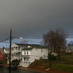
A line of showers moved through metro Richmond this morning with some gusty winds and brief heavy rain. No severe weather watches or warnings were issued for counties in the immediate vicinity of metro Richmond. As of 10 AM, Church Hill received 0.13″ of rain.
Severe weather may be possible tonight with an approaching cold front from the west. The NWS has classified areas south of Richmond with a 2% chance of seeing tornadoes during the overnight hours. Wind damage is also a possibility if a squall line develops tonight.
* Place – Time: Church Hill, 8 PM -12 AM(1/20/2012)
* Temperature: 37 (Falling to 31)
* Dewpoint: 24-32 (Rising)
* Relative Humidity: N/A
* Pressure: N/A
* Trends: Event started as light snow, which quickly turned to sleet and freezing rain.
* Precipitation Description: Snow, to sleet, to freezing rain and finally rain.
* Total Precip: Light coating of ice on cars, trees and elevated surfaces.
* Comments: Moisture arrived from the south and west and started as a little bit of light snow and sleet mix. The mix quickly converted over to sleet and freezing rain. Freeing rain lasted until 12 AM before turning over to light rain. Close to half an inch (0.48 as of 1/21/2012) of rain fell. No significant or measurable ice fell in Richmond.
Another fast moving clipper combined with a low-pressure system developing in the lower plains/Tennessee Valley will give the Richmond area a chance of sleet/rain mix this evening into early Saturday morning. The local meteorologists have hinted at this possible scenario for about two days now and have kept it in the forecast.
No accumulating snow is expected at this point. It looks like you will have to go as far north as Maryland (maybe DC/NOVA) to see any appreciable accumulation of snow or ice.
Normally this type of event would not be worth commenting on. However, Richmond has not seen any accumulating snow as of today (1/20/2012) or in any of the previous months of this winter season. Therefore, there is a little excitement in the air to have the possibility of even a small wintry event tonight into tomorrow morning.
NBC12 has also hinted at a small chance of freezing rain tomorrow night (1/21 to 1/22) as another round of precipitation rolls in.
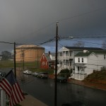
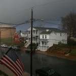
Below are a few photos from a squall line that rolled through on December 27, 2011. It was a potent batch of rain and wind that was quickly followed by a double rainbow.