Deprecated: Optional parameter $selected declared before required parameter $args is implicitly treated as a required parameter in /home/richmon/domains/richmondcitywatch.com/public_html/rvawx_test/wp-content/plugins/archives-calendar-widget/arw-settings.php on line 178
Deprecated: Optional parameter $view declared before required parameter $args is implicitly treated as a required parameter in /home/richmon/domains/richmondcitywatch.com/public_html/rvawx_test/wp-content/plugins/archives-calendar-widget/arw-widget.php on line 480
Deprecated: Optional parameter $archiveMonth declared before required parameter $args is implicitly treated as a required parameter in /home/richmon/domains/richmondcitywatch.com/public_html/rvawx_test/wp-content/plugins/archives-calendar-widget/arw-widget.php on line 480
Warning: Trying to access array offset on value of type bool in /home/richmon/domains/richmondcitywatch.com/public_html/rvawx_test/wp-content/plugins/archives-calendar-widget/archives-calendar.php on line 64 Winter Weather | RVAWX.com | Page 4
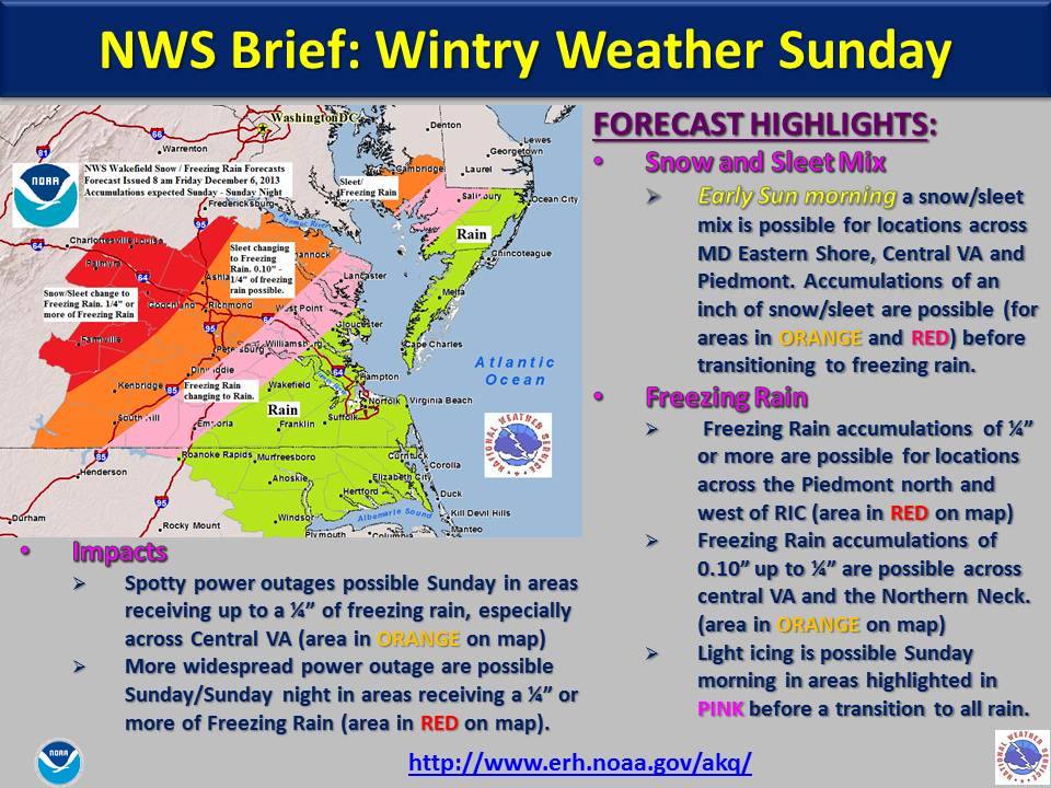
A complex storm system is shaping up for the day on Sunday across Central Virginia. An arctic front is sweeping across the region on Saturday which will set the stage for cold air damning to set up on the day Sunday. The arctic front will stall across the Carolinas on Sunday while two separate pulses of energy will overspread precipitation on Sunday morning. Initial NWS forecast calls for sleet and freezing rain in the morning, followed by freezing rain changing to rain in the afternoon. Temperatures will likely be marginal at best for ice accumulation in Metro Richmond, but will be worth watching to see how much actually accumulates during the day Sunday.
* Place – Time: Chesterfield Government Complex, 3:00 PM (11/12/2013)
* Temperature: 40-41, During Event
* Dewpoint: 29-30, During Event
* Relative Humidity: N/A%
* Pressure: N/A
* Trends: N/A
*Winter Weather Watch/Warning/Advisory: N/A
* Road Conditions: All roads remained passable, no accumulation.
* Precipitation Description: Light rain and snow showers persisted on and off during the afternoon hours.
* Total Precipitation: Trace of snow. Liquid equivalent of 0.0” fell during the event.
* Comments: A rain/snow mix started shortly after 1:15 PM. The snow persisted for about 20 minutes. Precipitation ended around 2 PM. No accumulation of snow was observed due to high air and ground temperatures. This was the first snow event of the 2013-2014 winter season.
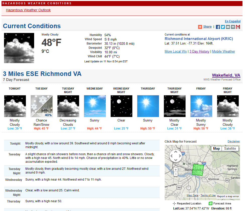
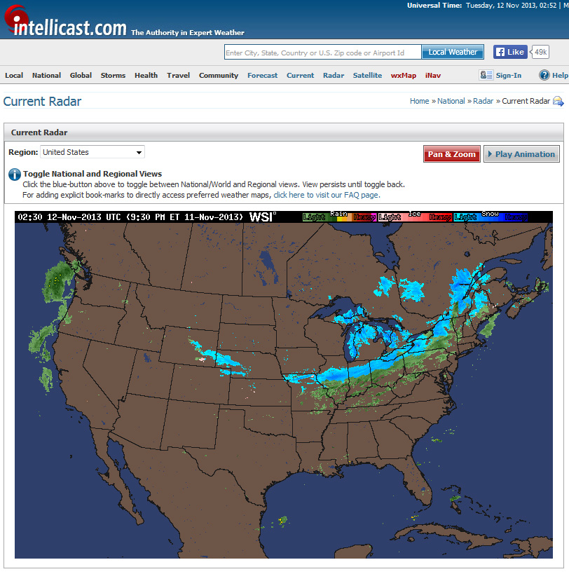
An arctic front will cross the region tomorrow bringing much cooler temperatures into Central Virginia. One feature of the system could be the season’s first appearance of snow. No accumulation is expected per the NWS forecast.
NWS Forecast11/11/13 Radar
THIS HAZARDOUS WEATHER OUTLOOK IS FOR THE LOWER EASTERN SHORE OF
MARYLAND...COASTAL NORTHEAST NORTH CAROLINA...INTERIOR NORTHEAST
NORTH CAROLINA...CENTRAL VIRGINIA...EAST CENTRAL
VIRGINIA...INTERIOR SOUTHEAST VIRGINIA...SOUTH CENTRAL
VIRGINIA...SOUTH HAMPTON ROADS VIRGINIA...THE EASTERN SHORE OF
VIRGINIA...THE MIDDLE PENINSULA OF VIRGINIA...THE NORTHERN NECK OF
VIRGINIA...THE PENINSULA OF SOUTHEAST VIRGINIA AND THE PIEDMONT OF
CENTRAL VIRGINIA.

.DAY ONE...TONIGHT.

HAZARDOUS WEATHER IS NOT EXPECTED AT THIS TIME.

.DAYS TWO THROUGH SEVEN...TUESDAY THROUGH SUNDAY.

A STRONG COLD FRONT WILL DROP ACROSS THE AREA TUESDAY...BRINGING
THE COLDEST AIR OF THE SEASON TO DATE TO THE MID-ATLANTIC REGION.
RAIN SHOWERS MAY MIX WITH A FEW WET SNOWFLAKES BEHIND THE FRONT
ON TUESDAY THROUGH TUESDAY EVENING...THOUGH NO IMPACTS TO TRAVEL
ARE EXPECTED. ALSO...WIND GUSTS TO 30 MPH WILL BE POSSIBLE TUESDAY
AND TUESDAY NIGHT.

.SPOTTER INFORMATION STATEMENT...
* Place – Time: Church Hill, 11:00 AM (3/7/2013) *After the Event Update*
* Temperature: 33-37, During Storm Event
* Dewpoint: 33-36, During Storm Event
* Relative Humidity: 100%
* Pressure: N/A
* Trends: N/A
*Winter Weather Watch/Warning/Advisory: Advisory
* Road Conditions: All roads had snow cover during the event. The morning after the event, secondary roads remained mostly clear in the city and south and eastern portions of the metro area. All major roads passable.
* Precipitation Description: Light, moderate and sometimes brief periods of heavy snow fell throughout the event.
* Total Precipitation: 1.5″ of snow (unconfirmed due to wet snow ratios and quick melting by the time I got home (1 PM), will use airport’s measurement in lieu of any actual measurements in Church Hill). Liquid Equivalent of 2.25″ fell during the event at my house. Liquid Equivalent of 2.1″ fell during the event at the airport.
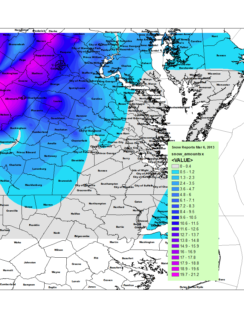
* Comments: A rain/snow mix started shortly after 8 AM. The precipitation fell as a moderate rain/snow mix through most of my commute to work. By the time I reached the Courthouse area of Chesterfield, snow was quickly accumulating on all surfaces, even the roadways. Snow was wet and heavy, flakes were incredibly large as well. Reports of thunder snow were reported throughout the metro area in the morning. Snow remained heavy until 9:30 AM and became moderate to light in intensity for the rest of the morning. Snow and rain/snow mix occurred throughout the rest of the morning and afternoon hours. Accumulation of snow essentially stopped around 10 AM as temperatures climbed to 37 and snow began melting. Precipitation was spurred by an upper level low that transferred to a surface low on the Virginia/NC border. The NWS was forecasting little in the way of snow for the metro area and scrambled early in the morning with Winter Storm Warnings and Advisories for the region. Areas in western Chesterfield and Henrico saw upwards of 5” of snow from the event. Areas east and south of town saw much less. The airport reported 1.5” of snow.
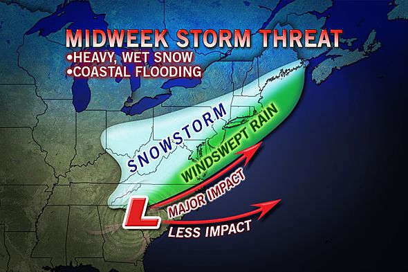
It looks like the impact from this storm is growing less and less…
.SHORT TERM /6 PM THIS EVENING THROUGH THURSDAY/…
FOR THE UPCOMING STORM SYSTEM TO AFFECT THE LOCAL AREA…GENLY
FOLLOWING HPC`S LEAD AND BLENDED SEVERAL OF THE 05/00Z MODELS
INCLUDING THE NAM/ECMWF/GFS. MAIN CHANGE WITH THIS FORECAST
PACKAGE IS DELAYING THE TRANSITION FROM RAIN TO RAIN/SNOW TO
SNOW…AND DECREASING SNOW TOTALS IN SOME AREAS.
WHAT HAS REMAINED FAIRLY CONSISTENT OVER THE PAST FEW DAYS
W/ THIS UPCOMING EVENT: MODELS HAVE BEEN SHOWING ABOUT 5 STD
DEVIATION ANOMALIES WITH RESPECT TO U COMPONENT OF 850 MB WIND
(I.E. STRONG/ANOMALOUS EASTERLY WINDS). ALTHOUGH EXACT LOCATION
HAS VARIED (GENLY BEING LOCATED OVER THE NRN MID ATLC REGION OR
FAR SOUTHERN NJ/PA). THIS TENDS TO BE A STRONG INDICATOR OF A
SIGNIFICANT EVENT ACRS AKQ CWA. THE OTHER FACTOR IS THE VERY
IMPRESSIVE FRONTOGENETIC FORCING OCCURRING ON THE NW SIDE OF THE
LOW TRACK…AND POTENTIAL FOR BANDING OF PRECIP. THE HIGHEST SNOW
AMOUNTS WILL BE LOCATED WITHIN THE NARROW BAND OF STRONGEST
FORCING AND ANY DEVIATION IN THE LOCATION OF THIS BAND WILL
DRASTICALLY CHANGE WHERE THE HIGHEST SNOWFALL ACCUMULATION OCCURS.
FOR NOW…THIS APPEARS TO RESIDE OVER THE FAR NWRN PART OF THE CWA. THE LAST FACTOR…WHICH WILL BE INHIBITING AT LEAST IN TERMS
OF SNOWFALL ACCUMULATION WILL BE A WARM BOUNDARY LAYER…AND FACT
THAT ENTIRE FA WILL SEE SIGNIFICANT ACCUMULATION OF RAIN TUE NGT/WED MRNG BEFORE THE CHANGEOVER. STILL..THINK DYNAMICALLY
DRIVEN COOLING DUE TO INTENSE LIFT AND PRECIP RATES WILL BE ABLE
TO OVERCOME THE WARMTH AT THE SFC. WHEN THIS OCCURS THE LOWER
LEVELS WILL BECOME COLD ENOUGH FOR THE PRECIP TO REMAIN
FROZEN…AND WITH THE STRONG FORCING AND HEAVY PRECIP RATES…SNOW
COULD BEGIN TO ACCUMULATE. WITH THE SFC LO TRENDING NORTH…THE
BEST CHC FOR WARNING–LVL SNOWFALL WILL BE OVER LOUISA AND
FLUVANNA…WHERE THE TRANSITION FROM RAIN TO SNOW WILL OCCUR IN
THE MRNG/MIDDAY HRS WED. FOR RICHMOND METRO…WITH HI LO-LVL
THICKNESSES AND THE H85/H5 LO PASSING DIRECTLY OVER THE AREA
(INSTEAD OF OFF TO THE SOUTH)…TRANSITION FROM RAIN TO SNOW MAY
BE DELAYED UNTIL THE AFTNHRS.
CONCERNING HEADLINES…WINTER STORM WATCH REMAINS ACRS THE
PIEDMONT FROM FVX TO LOUISA AND A FEW COUNTIES EAST. WATCH HAS NOT
BEEN EXPANDED SOUTH/EAST…WITH THE RICHMOND AREA MORE LIKELY TO
RECEIVE ONLY 1-2 INCHES. HAVE ADDED DORCHESTER COUNTY TO THE WATCH WITH THIS PACKAGE WHERE 3-4 INCHES IS POSSIBLE.
PRECIP DOES COME TO AN END FROM WEST TO EAST WED NIGHT INTO
THURSDAY MORNING WITH THE POTENTIAL FOR A SNEAKY WRAP-AROUND BAND
OF SNOW ON THE EASTERN SHORE BEFORE ALL IS SAID AND DONE.
AS FAR AS TEMPS…HIGHS WEDNESDAY IN THE MID 30S NW TO UPR 40S
SERN COASTAL AREAS. THURSDAY`S HIGHS IN THE MID TO UPR 40S. LOW
TEMPS GENERALLY IN THE 30S.
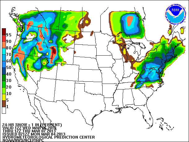
March 4, 2013: Updates
New images and discussion regarding the storm from the NWS:
.SHORT TERM /TUESDAY THROUGH WEDNESDAY NIGHT/…
FOR THE UPCOMING STORM SYSTEM TO AFFECT THE LOCAL AREA…GENLY
FOLLOWING A SOLUTION BLENDING THE 04/00Z RUNS OF THE NAM/ECMWF/GFS.
OVERALL THINGS HAVE NOT CHANGED THAT MUCH…THE GFS STILL IS A
FASTER AND FARTHER NORTH SFC LOW TRACK SOLUTION TENDING TO BE ON
THE NORTH EDGE OF ALL GUIDANCE. IT WOULD SUGGEST THE MAIN IMPACT
FOR ACCUMULATING SNOW WOULD BE OVER FAR NORTHERN PORTIONS OF THE CWA. THE 00Z NAM SOLUTION WOULD FAVOR A MUCH MORE SIGNIFICANT SNOW
ACCUMULATION OVER CENTRAL AND EVEN SOUTHERN VA. NOTE…LATEST 06Z NAM HAS TRENDED NORTH TO THE GFS…ALTHOUGH DO NOT GENLY FAVOR THE
06/18Z MODEL RUNS.
WHAT HAS REMAINED FAIRLY CONSISTENT OVER THE PAST FEW DAYS W/
THIS UPCOMING EVENT: MODELS HAVE BEEN SHOWING ABOUT 5 STD
DEVIATION ANOMALIES WITH RESPECT TO U COMPONENT OF 850 MB WIND
(I.E. STRONG/ANOMALOUS EASTERLY WINDS). ALTHOUGH EXACT LOCATION
HAS VARIED (GENLY BEING LOCATED OVER THE NRN MID ATLC REGION OR
FAR SOUTHERN NJ/PA). THIS TENDS TO BE A STRONG INDICATOR OF A
SIGNIFICANT EVENT ACRS AKQ CWA. THE OTHER FACTOR IS THE VERY
IMPRESSIVE FRONTOGENETIC FORCING OCCURRING ON THE NW SIDE OF THE
LOW TRACK…AND POTENTIAL FOR BANDING OF PRECIP. THE HIGHEST SNOW AMOUNTS
WILL BE LOCATED WITHIN THE NARROW BAND OF STRONGEST FORCING AND
ANY DEVIATION IN THE LOCATION OF THIS BAND WILL DRASTICALLY CHANGE
WHERE THE HIGHEST SNOWFALL ACCUMULATION OCCURS. FOR NOW…AND THIS
HAS BEEN FAIRLY CONSISTENT…THIS APPEARS TO RESIDE OVER NRN 1/2
TO 1/3 OF THE CWA. THE LAST FACTOR…WHICH COULD BE INHIBITING AT
LEAST IN TERMS OF SNOWFALL ACCUMULATION WILL BE WARM BOUNDARY
LAYER…AND FACT THAT ENTIRE REGION EXCEPT FOR POSSIBLY THE FAR NW
WILL SEE SIGNIFICANT ACCUMULATION OF RAIN TUE NIGHT BEFORE THE
CHANGEOVER. STILL..THINK DYNAMICALLY DRIVEN COOLING DUE TO INTENSE
LIFT AND PRECIP RATES WILL BE ABLE TO OVERCOME THE WARMTH AT THE SFC. WHEN THIS OCCURS THE LOWER LEVELS WILL BECOME COLD ENOUGH FOR
THE PRECIP TO REMAIN FROZEN…AND WITH THE STRONG FORCING AND
HEAVY PRECIP RATES…SNOW COULD BEGIN TO ACCUMULATE VERY QUICKLY.
CONCERNING HEADLINES…HAVE RAISED A WINTER STORM WATCHACRS THE
PIEDMONT FROM FVX TO LOUISA AND A FEW COUNTIES EAST. THIS IS DUE
TO POTENTIAL FOR ACCUMULATING SNOW TO BEGIN WITHIN 48HRS…PRIOR
TO 12Z/WED. FARTHER EAST…THE CHANGEOVER/OR AT LEAST TIME WHEN
SNOW BEGINS TO ACCUMULATE IS GENLY EXPECTED AFTER 12Z. THIS IS THE
REASON FOR NO WATCH AT THIS TIME IN THESE AREAS (LATER SHIFTS WILL
NEED TO CONSIDER EXPANDING DEPENDING ON MODEL TRENDS). FCST GENLY HAS
SNOW BECOMING MAIN P-TYPE ACRS MUCH OF METRO RICHMOND SOMETIME
BETWEEN 12-18Z/WED…ALTHOUGH THIS IS UNCERTAIN AND WOULD NOT BE
SURPRISED TO SEE SHARP CUTOFF WITHIN THE METRO AREA ITSELF. EXPECT
A SIGNIFICANT SNOWFALL/SEVERAL INCHES FOR MUCH OF CENTRAL AND
POSSIBLY EAST CENTRAL VA AND INTO DORCHESTER MD SOMETIME LATER
WED-WED EVENING.
THE KEY POINT OF THIS EVENT IS THAT THIS STORM WILL CREATE A
HIGHLY DYNAMIC ENVIRONMENT AND THE LACK OF COLD AIR AT THE SURFACE
COULD BE OVERCOME BY COOLING FROM ALOFT WITH A PERIOD OF VERY HEAVY SNOW RESULTING OVER PORTIONS OF THE FORECAST AREA WEST AND
NORTH OF A FARMVILLE-RICHMOND-SALISBURY LINE. ALTHOUGH THERE HAS
BEEN SOME MODEL RUN TO RUN CONSISTENCY…THIS WX SCENARIO IS
HIGHLY VARIABLE AND PINPOINTING SPECIFICS IN
TIMING/LOCATION/AMOUNTS IS EXTREMELY DIFFICULT.
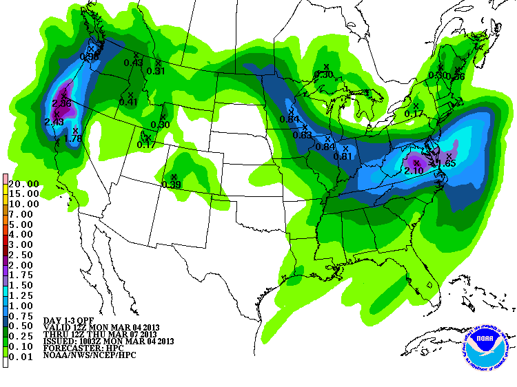
March 2, 2013: The weather models have the lower mid-Atlantic pegged for a substantial weather system next week that is spurred by a system dropping through the Rockies, into Kentucky and Tennessee and then rapidly redeveloping off the North Carolina Coast. Being March, temperatures and intensity of the storm are going to be critical in the forecast for any snowfall in Central Virginia. The Euro model has piled up impressive snow amounts for Virginia in the last two days. As always, following the latest trends is going to be key in making a forecast for next week. As of Saturday morning, a HWO has been issued by the NWS in Wakefield:
.DAYS TWO THROUGH SEVEN...SUNDAY THROUGH FRIDAY.
STRONG LOW PRESSURE WILL INTENSIFY OFF THE MID ATLANTIC OR SOUTHEAST
COAST WEDNESDAY THROUGH THURSDAY. MAINLY RAIN IS ANTICIPATED LATE TUESDAY
NIGHT THROUGH WEDNESDAY MORNING...BEFORE THE PRECIPITATION MIXES
WITH OR CHANGES TO WET SNOW WEDNESDAY AFTERNOON THROUGH WEDNESDAY
NIGHT.
An arctic cold front will swing through central Virginia tonight and usher in a new round of cold air for the weekend. Along the cold front, a low pressure system may develop during the day on Saturday to bring some light rain and snow showers to the area. Accumulations will likely be light. The system bears watching for some accumulating snowfall.
* Place – Time: Church Hill, 11:00 AM (2/3/2013) *After the Event Update*
* Temperature: N/A
* Dewpoint: N/A
* Relative Humidity: 100%
* Pressure: N/A
* Trends: N/A
*Winter Weather Watch/Warning/Advisory: Advisory
* Road Conditions: All roads had snow cover during the event. Both secondary and major roads had snow cover on them during and after the event.
* Precipitation Description: Light and moderate snow fell throughout the event.
* Total Precip: 1.25″ of snow. Liquid Equivalent of 0.11″ fell during the event at my home.
* Comments: Snow began around 1 PM on the 25th. The precipitation fell as light to occasionally moderate snow throughout the afternoon hours. The snow began to taper off by 5:30 PM. Snow was very dry and fluffy. The airport reported 1.4” of snow.
This ended up being a fairly minor event with approximately 0.2″ of snow accumulation.
My Report (Church Hill):
* Place – Time: Church Hill, 11:00 AM (2/3/2013) *After the Event Update*
* Temperature: N/A
* Dewpoint: N/A
* Relative Humidity: N/A
* Pressure: N/A
* Trends: N/A
*Winter Weather Watch/Warning/Advisory: None
* Road Conditions: All roads had snow cover during the event. The morning after the event, secondary roads remained covered. Most major roads cleared.
* Precipitation Description: Light snow fell throughout the event.
* Total Precip: 0.2″ of snow. Liquid Equivalent of a trace fell during the event at the airport.
* Comments: Snow started shortly after midnight on the 24th. The precipitation fell as light to occasionally moderate snow throughout the early morning hours. The airport reported 0.2” of snow.
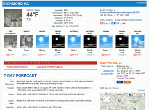
URGENT - WINTER WEATHER MESSAGE...UPDATED
NATIONAL WEATHER SERVICE WAKEFIELD VA
648 AM EST THU JAN 17 2013

MDZ021>023-VAZ060-065>083-085-172000-
/O.CON.KAKQ.WS.W.0001.130117T2300Z-130118T0600Z/
DORCHESTER-WICOMICO-SOMERSET-PRINCE EDWARD-MECKLENBURG-LUNENBURG-
NOTTOWAY-AMELIA-POWHATAN-CHESTERFIELD-HENRICO-KING WILLIAM-
KING AND QUEEN-ESSEX-WESTMORELAND-RICHMOND-NORTHUMBERLAND-
LANCASTER-BRUNSWICK-DINWIDDIE-PRINCE GEORGE-CHARLES CITY-NEW KENT-
MIDDLESEX-
INCLUDING THE CITIES OF...CAMBRIDGE...SALISBURY...CRISFIELD...
PRINCESS ANNE...FARMVILLE...SOUTH HILL...CREWE...
COLONIAL HEIGHTS...RICHMOND...TAPPAHANNOCK...LAWRENCEVILLE...
PETERSBURG...HOPEWELL
648 AM EST THU JAN 17 2013

...WINTER STORM WARNING REMAINS IN EFFECT FROM 6 PM THIS EVENING
TO 1 AM EST FRIDAY...

A WINTER STORM WARNING REMAINS IN EFFECT FROM 6 PM THIS EVENING
TO 1 AM EST FRIDAY.

* AREAS AFFECTED: THE VIRGINIA NORTHERN NECK AND MARYLAND
  EASTERN SHORE.

* HAZARDS: SNOW.

* ACCUMULATIONS: 3 TO 4 INCHES.

* TIMING: RAIN WILL QUICKLY CHANGE TO SNOW EARLY THIS EVENING AND
  BEGIN TO ACCUMULATE SHORTLY AFTER SUNSET. A BRIEF PERIOD OF
  HEAVY SNOWFALL THIS EVENING WILL CAUSE RAPID ACCUMULATIONS TO
  OCCUR. SNOW WILL END LATE TONIGHT.

* IMPACTS: SNOW...HEAVY AT TIMES...WILL ACCUMULATE ON ROADS AFTER
  SUNSET AND CREATE HAZARDOUS DRIVING CONDITIONS.

PRECAUTIONARY/PREPAREDNESS ACTIONS...

A WINTER STORM WARNING MEANS SIGNIFICANT AMOUNTS OF SNOW ARE
EXPECTED. STRONG WINDS ARE ALSO POSSIBLE. THIS WILL MAKE TRAVEL
VERY HAZARDOUS OR IMPOSSIBLE."
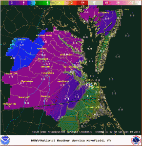
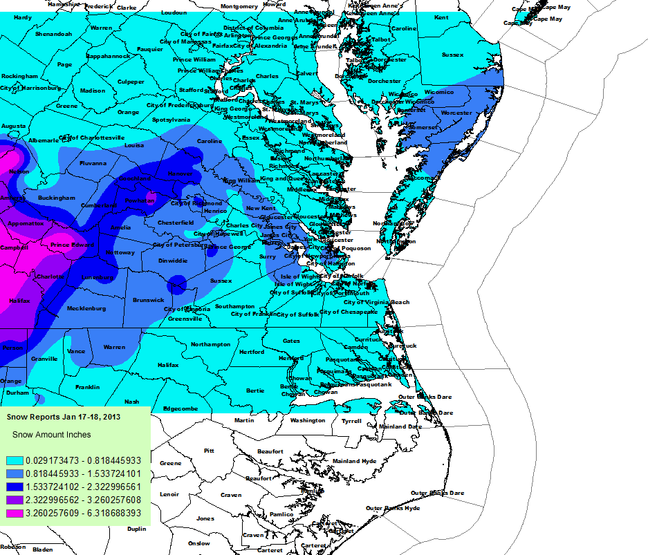
NWS Final Snow TotalsNWS Snow Total Map
My Report (Church Hill):
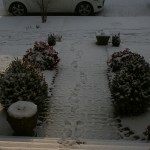
* Place – Time: Church Hill, 11:00 AM (1/18/2013) *After the Event Update*
* Temperature: 33-37, During Storm Event
* Dewpoint: 33-37, During Storm Event
* Relative Humidity: 100%
* Pressure: N/A
* Trends: N/A
*Winter Weather Watch/Warning/Advisory: Watch & Warning
* Road Conditions: All roads had snow cover during the event. The morning after the event, secondary roads remained slushy. Most major roads passable.
* Precipitation Description: Light, moderate and sometimes brief periods of heavy snow fell throughout the event. I observed thunder snow at the onset of the snow in western Chesterfield County (near St. Francis Hospital).
* Total Precip: 2.0″ of snow. Liquid Equivalent of 0.64″ fell during the event at the airport.
* Comments: A rain/snow mix started shortly after sunset on the 17th. The precipitation fell as light to occasionally moderate snow throughout the evening hours. Snow began to accumulate within one hour of transitioning to snow. The precipitation quickly changed to moderate and heavy snow by 6 PM where local roads began to get covered. One hour of moderate snow was reported in and around RIC airport around 9 PM. The snow began to taper off by 11:00 PM as it transitioned between rain and snow. Snow was very wet, with ratios close to 3.3:1. Precipitation was spurred by an upper level low that tracked up from northern Alabama to off the Virginia coast. This storm came at the end of a long week of rain that occurred each day, starting on 1/14/13. The airport reported 1.6” of snow.