The major winter storm (termed “Euclid” from TWC) that churned through yesterday brought a round of heavy rain to central Virginia. No snow or sleet was reported at the airport. In addition, I did not see any sleet or snow during the beginning at the event. My location in Church Hill received 1.24″ of rain yesterday. As of today, we still do not have any snow observations for the season in Richmond.
Category Archives: Forecast Discussion
What do the models say? What are the local mets saying? Discuss it here.
December 26-27, 2012: Forecast for Snow/Sleet to Rain
The day after Christmas, a complex and potentially potent storm system will develop over the southern United States and track to the northeast. The low will redevelop near Richmond and then track northeastward towards across the Delmarva peninsula. The forecast for this system seemed more promising about 8-10 days out with a higher chance of rain and snow for the Richmond metro area. Today, the weather models have shifted and focused the brunt of the winter weather to interior portions of the Ohio Valley, Mid-Atlantic and Northeast corridor (interior regions).
It’s worth mentioning this storm now since their is a small chance of Richmond’s having its first snowfall/sleet/freezing rain event of the season. The NWS has made mention of the snow/sleet potential for this storm system early Wednesday Morning.
As of today, we have not seen any wintry weather in Richmond. Here is to hoping that we can catch a few flakes or pellets from this system before it turns to rain (which could be as much as .75 – 1.5″ of rain).
First Freeze of 2012 Fall Season
It’s October 25th and we still haven’t seen the first freeze in Metro Richmond. Any guess on when it might come?
Update: The airport recorded the first freezing temperature on 11/3. At Church Hill, the first freeze was recorded on 11/6 (Low of 29.9).
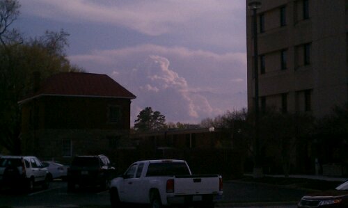
More storm clouds…
Looking south from the Chesterfield Courthouse.
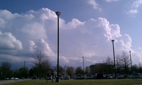
Springtime cumulonimbus…
March 5, 2012: Forecast for Clipper Snow?
It looks like a potent clipper system diving through the upper midwest will be arriving in Central Virginia by 5 AM.The forecast is for around 1-3″ of snow. It’ll be interesting to see how much accumulation we get on Monday morning!


URGENT - WINTER WEATHER MESSAGE
NATIONAL WEATHER SERVICE WAKEFIELD VA
1029 PM EST SUN MAR 4 2012

NCZ012-VAZ060-061-065>071-079>081-087-088-092-051130-
/O.CON.KAKQ.WW.Y.0004.120305T0900Z-120305T1700Z/
NORTHAMPTON NC-PRINCE EDWARD-CUMBERLAND-MECKLENBURG-LUNENBURG-
NOTTOWAY-AMELIA-POWHATAN-CHESTERFIELD-HENRICO-BRUNSWICK-DINWIDDIE-
PRINCE GEORGE-GREENSVILLE-SUSSEX-SOUTHAMPTON-
INCLUDING THE CITIES OF...MARGARETTSVILLE...FARMVILLE...
SOUTH HILL...CREWE...COLONIAL HEIGHTS...RICHMOND...
LAWRENCEVILLE...PETERSBURG...HOPEWELL...EMPORIA...WAKEFIELD...
FRANKLIN
1029 PM EST SUN MAR 4 2012

...WINTER WEATHER ADVISORY REMAINS IN EFFECT FROM 4 AM TO NOON
EST MONDAY...

A WINTER WEATHER ADVISORY REMAINS IN EFFECT FROM 4 AM TO NOON EST
MONDAY.

* AREAS AFFECTED: THE EAST CENTRAL VIRGINIA PIEDMONT THROUGH
  SOUTH CENTRAL VIRGINIA AND NORTHAMPTON COUNTY NORTH CAROLINA.

* HAZARDS: SNOW

* ACCUMULATIONS: PRIMARILY 1 TO 2 INCHES...WITH ISOLATED AMOUNTS
  UP TO 3 INCHES IN THE SOUTH CENTRAL VIRGINIA PIEDMONT.

* TIMING: EARLY MONDAY MORNING...INCLUDING RUSH HOUR AND THROUGH
  MIDDAY.

* IMPACTS: SNOW SHOULD MAINLY ACCUMULATE ON NON-PAVED AND ELEVATED
  SURFACES SUCH AS BRIDGES AND OVERPASSES.

PRECAUTIONARY/PREPAREDNESS ACTIONS...

A WINTER WEATHER ADVISORY FOR SNOW MEANS THAT PERIODS OF SNOW
WILL CAUSE PRIMARILY TRAVEL DIFFICULTIES. BE PREPARED FOR SNOW
COVERED ROADS AND LIMITED VISIBILITY...AND USE CAUTION WHILE
DRIVING.
RVAWX Now on Facebook and Twitter
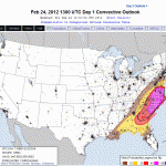
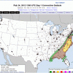
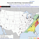
February 24, 2012: Severe Weather Threat?
The severe weather outlook looks quite ominious for this afternoon:

- NWS Wind Damage Chances

February 19, 2012: Richmond Snow Event, Radar Loop
Radar Loop from KAKQ for the entire event here:
February 19, 2012: Forecast for Rain to Snow?
Could Metro Richmond be in store for a President’s Day storm in 2012? The likelihood of a possible winter weather event for Central Virginia is gaining traction today. A lot of caution needs to be placed on the table as the models for this event have been all over the board this week. On Sunday and Monday, the lower Middle Atlantic seemed to be in the cross-hairs of a potential major storm for this weekend. By mid-week, the threat shifted north and east of Central Virginia to include DC through NYC. The models (for the time being) have reined in the idea of a coastal storm exiting Carolina coast and cruising up the eastern seaboard. Now, the storm stays suppressed and hammers the majority of the wintery precipitation through WVA, VA and parts of MD and DE. Still a lot of time for the models and overall model consensus on this storm to shift. In the meantime, Richmond has a slight chance of having our first major winter storm of the season.
Below are some current predictions based on the models this afternoon:


Updates for 2/17/2012:
The chances for accumulating snow Sunday afternoon, evening and early Monday are increasing. The NAM this morning buried Richmond with 8-11″ of snow. I’m still unsure if this will pan out, but it looks like we have something fun to watch! Also, the 12Z GFS today still shows 3-4″ of snow for Richmond. The trend looks to be our friend if you are a snow lover!
