Deprecated: Optional parameter $selected declared before required parameter $args is implicitly treated as a required parameter in /home/richmon/domains/richmondcitywatch.com/public_html/rvawx_test/wp-content/plugins/archives-calendar-widget/arw-settings.php on line 178
Deprecated: Optional parameter $view declared before required parameter $args is implicitly treated as a required parameter in /home/richmon/domains/richmondcitywatch.com/public_html/rvawx_test/wp-content/plugins/archives-calendar-widget/arw-widget.php on line 480
Deprecated: Optional parameter $archiveMonth declared before required parameter $args is implicitly treated as a required parameter in /home/richmon/domains/richmondcitywatch.com/public_html/rvawx_test/wp-content/plugins/archives-calendar-widget/arw-widget.php on line 480
Warning: Trying to access array offset on value of type bool in /home/richmon/domains/richmondcitywatch.com/public_html/rvawx_test/wp-content/plugins/archives-calendar-widget/archives-calendar.php on line 64 changeover | RVAWX.com | Page 2
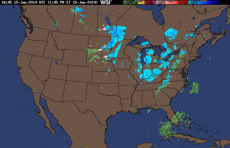
A possible light winter weather event may occur tonight from a weak system moving across the area. Little to no accumulation of snow is excepted. However, with no accumulating snow yet this season, there is a slim chance this could serve to be the first event to give us more than a trace of snowfall.
US Radar on 1/15/2014 around 2 PM
NWS Discussion:
.SHORT TERM /6 PM THIS EVENING THROUGH FRIDAY/… ACTIVE NRN STREAM RMNS DOMINANT THROUGH FRI. COLDER AIR GRADUALLY
SPREAD OVR THE RGNTNGT…AS LO PRES IS SLO TO DVLP OFF THE CST.
WKNG S/W ALOFT CROSSES THE RGNTNGT/THU MRNG KEEPING MOISTURE AND
RATHER WKUVM (BTWN H85-H7). MAY BE ENOUGH TO SQUEEZE OUT LGTPCPN TNGT…ESP INLAND. WINTER PARAMETERS CONT TO SUGGEST LO PROB FOR
TRANSITION TO MIXED PTYPE OR (JUST) SN STARTING OUT OVR THE PDMNT
AND SLOLY SPREADING E (BY ERY THU MRNG). QPF IS XPCD TO BE AOB
0.05″…PTNTLLY ENUF FOR A SMALL/SLUSHY ACCUM FOR PARTS OF THE
AREA W OF I 95. LO TEMPS FM THE U20S FAR W TO THE M30S TO THE E.
HOLDING ONTO CLDS AND CHCPOPSNR THE CST THU MRNG ASSOCIATED W/
DVLPG LO PRES OFFSHR. A CLRG TREND FM W TO E XPCD MIDDAY THROUGH AFTN AS THAT LO BEGINS TO PULL AWAY FM THE CST. YET ANOTHER CDFNT
APPROACHES FM THE W ON FRI…REACHING THE CST VERY LT IN THE DAY. MOISTUREFM THAT SYS LIMITED…SO POPS TO BE QUITE LO (AOB 14% FOR
NOW). OTRW…CLR-PC THU NGT THROUGH FRI.
HIGHS TEMPS THU WILL ONLY RECOVER INTO THE L/M 40S. FEW GUSTS UP
TO 20-30 MPH POSSIBLE ALONG THE COAST THU MRNG. MILDER FRI W/ HI
TEMPS FM THE M40S TO L50S.
Update from 4 PM on 1/15/2014:
WITH THAT SAID…EXPECT PRECIP TO DEVELOP OVER THE PIEDMONT LATE
TODAY INTO EARLY THIS EVENING AND PERSIST THROUGH LATE
TONIGHT…REMAINING ALONG AND WEST OF INTERSTATE 95. WHILE PRECIP
WILL BE LIGHT…HAVE OPTED TO INCREASE POPS TO LIKELY. THICKNESSES
BEGIN TO RAPIDLY FALL THIS EVENING AS COLDER AIR SURGES INTO THE
REGION. HOWEVER…TEMPS ONLY EXPECTED TO FALL INTO THE LOW
30S…SO TRANSITION OVER TO SNOW WILL BE SLOW…LIKELY OCCURRING
AFTER MIDNIGHT. EXPECT SNOWFALL AS FAR EAST AS INTERSTATE 95 BY
THURS MORNING. QPF WILL LIKELY BE LESS THAN ONE TENTH OF AN INCH.
ANTICIPATE ONLY MINOR/SLUSHY SNOW ACCUMULATIONS (<.05 INCHES) ON
GRASSY OR COLD SURFACES FROM FARMVILLE NWD TO LOUISA…WELL BELOW
ADVISORY CRITERIA.
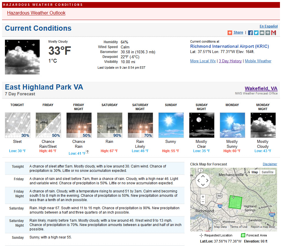
A brief and light wintry event may occur early tomorrow morning in Central Virginia. According to the NWS, it appears to be a minor event:
MDZ021-022-VAZ070>076-079>083-102115-
DORCHESTER-WICOMICO-CHESTERFIELD-HENRICO-KING WILLIAM-KING AND QUEEN-
ESSEX-WESTMORELAND-RICHMOND-BRUNSWICK-DINWIDDIE-PRINCE GEORGE-
CHARLES CITY-NEW KENT-
415 PM EST THU JAN 9 2014

THIS HAZARDOUS WEATHER OUTLOOK IS FOR THE LOWER EASTERN SHORE OF
MARYLAND...CENTRAL VIRGINIA...EAST CENTRAL VIRGINIA...SOUTH CENTRAL
VIRGINIA...THE MIDDLE PENINSULA OF VIRGINIA AND THE NORTHERN NECK
OF VIRGINIA.

.DAY ONE...TONIGHT.

THERE IS A POTENTIAL FOR A BRIEF PERIOD OF LIGHT SLEET LATE
TONIGHT INTO EARLY FRIDAY MORNING. LITTLE TO NO ACCUMULATION IS
EXPECTED.
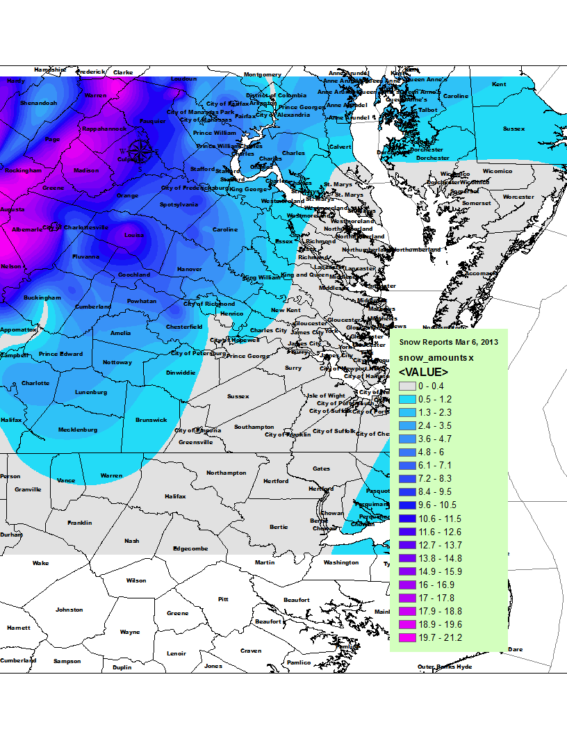
* Place – Time: Church Hill, 11:00 AM (3/7/2013) *After the Event Update*
* Temperature: 33-37, During Storm Event
* Dewpoint: 33-36, During Storm Event
* Relative Humidity: 100%
* Pressure: N/A
* Trends: N/A
*Winter Weather Watch/Warning/Advisory: Advisory
* Road Conditions: All roads had snow cover during the event. The morning after the event, secondary roads remained mostly clear in the city and south and eastern portions of the metro area. All major roads passable.
* Precipitation Description: Light, moderate and sometimes brief periods of heavy snow fell throughout the event.
* Total Precipitation: 1.5″ of snow (unconfirmed due to wet snow ratios and quick melting by the time I got home (1 PM), will use airport’s measurement in lieu of any actual measurements in Church Hill). Liquid Equivalent of 2.25″ fell during the event at my house. Liquid Equivalent of 2.1″ fell during the event at the airport.
* Comments: A rain/snow mix started shortly after 8 AM. The precipitation fell as a moderate rain/snow mix through most of my commute to work. By the time I reached the Courthouse area of Chesterfield, snow was quickly accumulating on all surfaces, even the roadways. Snow was wet and heavy, flakes were incredibly large as well. Reports of thunder snow were reported throughout the metro area in the morning. Snow remained heavy until 9:30 AM and became moderate to light in intensity for the rest of the morning. Snow and rain/snow mix occurred throughout the rest of the morning and afternoon hours. Accumulation of snow essentially stopped around 10 AM as temperatures climbed to 37 and snow began melting. Precipitation was spurred by an upper level low that transferred to a surface low on the Virginia/NC border. The NWS was forecasting little in the way of snow for the metro area and scrambled early in the morning with Winter Storm Warnings and Advisories for the region. Areas in western Chesterfield and Henrico saw upwards of 5” of snow from the event. Areas east and south of town saw much less. The airport reported 1.5” of snow.
Current & Historical Weather Events in Richmond, Virginia